
Home » Regions » North America » Eastern Temperate Forests » Mixed Wood Plains » Northeastern Coastal Zone » Connecticut Valley
Connecticut Valley
Last updated: August 24th, 2020
Page contents
↑About the Connecticut Valley
The Connecticut Valley is a region mostly oriented north-south, extending from the coast, through central Connecticut, through Massachusetts, and just into the corners of Vermont and New Hampshire on the border between the two states. There is also a small discontinuous piece of this region in the Pomperaug valley in western Connecticut.The topography ranges from level to rolling hills. The underlying bedrock is mostly sedimentary, including arkose and other sandstones, siltstone, shale, and conglomerate, but there are some basalt layers, which stand out as ridges in the landscape. One of the most prominent basalt ridges runs north-south through much of the region, and curves to the east to form the Holyoke range. In addition to these rocks, the valley has more recent sedimentary deposits, including glacial outwash, alluvium, and lake bottom deposits. The climate is towards the milder end of a humid continental climate, with roughly constant precipitation year-round.
Natural forest cover here had a greater portion of Oak-Hickory forests than surrounding upland regions, and also had some regions transitional between this and northern hardwoods. Floodplain forests were dominated by silver maple (Acer saccharinum) and eastern cottonwood (Populus deltoides).
Compared to surrounding upland areas, the region has a milder climate, a lower portion of glacial till, more level terrain, and richer soils overall. All of these factors make the region more suited to both agriculture and urbanization. This area has the most extensive farmland of any area in the New England coastal zone, and it has greater urbanization of the inland regions. Throughout much of this area, only small, fragmented forests remain, but the basalt ridges are still largely forested.
This region is bordered to the south by the heavily-populated Long Island Sound Coastal Lowland, which also has a milder climate. North of that, it is surrounded to the east and west by the more rugged Southern New England Coastal Plains and Hills. A bit farther north, it is bordered to the east by the Lower Worcester Plateau/Eastern Connecticut Upland and to the west by the Berkshire Transition. Slightly north of that it is bordered to the west by the Vermont Piedmont. Farther north, where it is now quite narrow, it is bordered on both east and west by the Worcester/Monadnock Plateau, and at its northermost end it is surrounded by the Vermont Piedmont again. With the exception of the coastal lowlands, all of these regions are more upland, and marked by clear geographic boundaries including changes in bedrock.
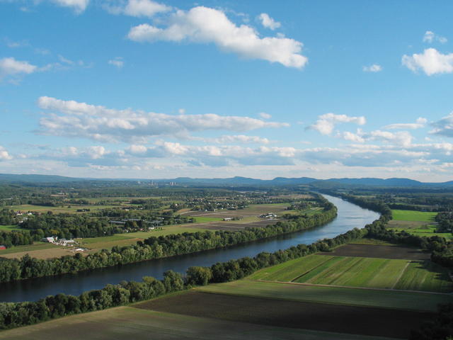 This photo shows the Connecticut Valley, directly along the Connecticut River, viewed from Mt. Sugarloaf, one of the prominent peaks on the basalt ridges; more ridges are visible in the background. This is an edit (adjusting lighting levels) of a photo by BenFrantzDale. Photo © BenFrantzDale (Wikimedia Commons), CC BY-SA 3.0, Source.
Plant Lists & In-Region Search
We do not yet have data to generate plant lists for a region as fine-tuned as this one. However you can move up to the broader Northeastern Coastal Zone and generate lists for that region: native plants or all plants. Or search that region's plants here:
↑References
1. Griffith, G.E., Omernik, J.M., Bryce, S.A., Royte, J., Hoar, W.D., Homer, J.W., Keirstead, D., Metzler, K.J., and Hellyer, G. "Ecoregions of New England (Poster)", U.S. Geological Survey (2009) Web.