
Home » Regions » North America » Northern Forests » Atlantic Highlands » Northeastern Highlands » Moosehead-Churchill Lakes
Moosehead-Churchill Lakes
Last updated: August 11th, 2020
Page contents
↑About the Moosehead-Churchill Lakes
The Moosehead-Churchill Lakes region is a relatively flat area of high elevation, mostly surrounded by more rugged areas of hills and mountains. It is located entirely within Maine, fairly far north and inland.This region consists of rolling plains, broad valleys, and low hills. There are numerous large lakes, as well as large wetlands and peatlands. Elevations mostly range from 900-1,400 feet. The area is mostly covered in loamy glacial till, with some sandy-loamy till. The bedrock is a mix of weakly metamorphized sedimentary rocks, volcanic rocks, and melange, but the bedrock is well-covered by till across most of the region.
Mooshead and Chesuncook lakes are the two largest lakes here; Moosehead is the largest lake in New England east of Lake Champlain. This small area contains several regional watershed divides. Moosehead lake drains to the Kennebec river and Chesuncook lake to the West Branch Penobscot river, whereas the more northerly lakes drain to the Allagash river which in turn flows into the St. John River. This region has a cold humid continental climate; the climate is only slightly warmer than surrounding upland areas. The presence of the lakes, which freeze completely in winter, slightly delays seasons but does not do much to moderate the coldest temperatures here. The larger lakes typically freeze in December and only become ice-free in late April or May. Smaller lakes freeze (and thaw) earlier.
Original forest cover varied by site. Cooler sites supported spruce-fir forest, with red spruce (Picea rubens), balsam fir (Abies balsamea), paper birch (Betula papyrifera), and yellow birch (Betula alleghaniensis). Warmer sites featured northern hardwood forest, with sugar maple (Acer saccharum), American beech (Fagus grandifolia), and yellow birch as dominants. There were some small areas of white pine-mixed conifer forest with eastern white pine (Pinus strobus) and various other species. Poorly drained areas supported northern white-cedar (Thuja occidentalis) swamps, and bogs with black spruce (Picea mariana) and tamarack (Larix laricina).
Forestry is intense in this region, and the forests here have been cleared and harvested repeatedly; much of the region consists of currently-regenerating forest, although there are also large areas of intact forest, including deciduous, evergreen, and mixed forests. There is also some open scrubland. Although most of the region is sparsely populated, development is concentrated near Greenville, the largest town here, located at the south end of Moosehead lake. A 2005 development proposal that would have roughly doubled the population of this town was recently abandoned. Besides forestry, this region is also utilized for hunting, fishing, and recreation.
This region is surrounded in an irregular border to the south by the rugged, high-elevation Quebec/New England Boundary Mountains, and to the north by the St. John Uplands, which also hillier and high-elevation but less so than the Quebec/New England Boundary Mountains. Although both of these areas are higher elevation on average, the rivers that flow out of this region cut through these areas at areas of lower elevation.
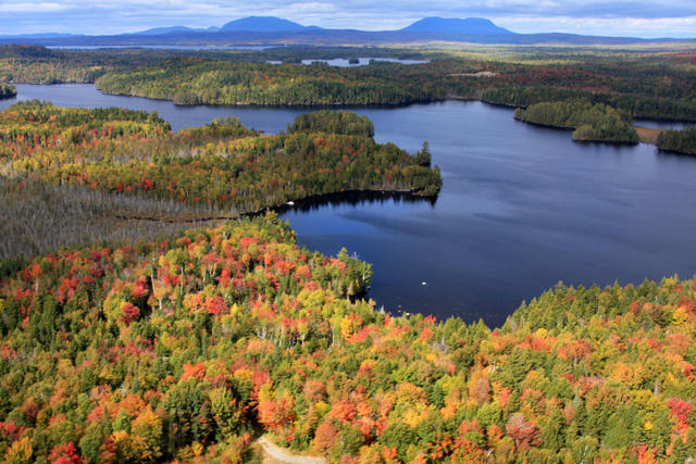 This aerial photo shows Moosehead Lake and its surroundings, which tend to be flat and have a mix of conifers and deciduous trees. The mix of trees is more distinctly visible in autumn. In the distance, you can also see the Quebec/New England Boundary Mountains.. Photo © Dana Moos, CC BY 2.0, Source.
Plant Lists & In-Region Search
We do not yet have data to generate plant lists for a region as fine-tuned as this one. However you can move up to the broader Northeastern Highlands and generate lists for that region: native plants or all plants. Or search that region's plants here:
↑References
1. Griffith, G.E., Omernik, J.M., Bryce, S.A., Royte, J., Hoar, W.D., Homer, J.W., Keirstead, D., Metzler, K.J., and Hellyer, G. "Ecoregions of New England (Poster)", U.S. Geological Survey (2009) Web.