
Home » Regions » North America » Eastern Temperate Forests » Mixed Wood Plains » Erie Drift Plain » Erie Gorges
Erie Gorges
Last updated: August 18th, 2020
Page contents
↑About the Erie Gorges
The Erie Gorges represent a area of steep gorges along the Chagrin, Cuyahoga, and Grand rivers in Northeast Ohio. This area is unique in its high local relief, exceeding 500 feet, contrasting with the mostly-flat surroundings. This region consists of two discontinuous pieces; the western one extends from Akron to Cleveland and contains the Cuyahoga valley, and the eastern portion encompasses most of the Grand and Chagrin rivers, which meet just outside this region.This region ranges in elevation from 575-1,300 feet (starting just above the level of Lake Erie), with local relief of 200 to over 500 feet. There are steep slopes and outcroppings of bedrock. This area is underlain by shale at lower levels, then sandstone, and conglomerate on the highest ridges. These rocks are in turn covered by glacial drift. The steep slopes result in large part from the lower levels of shale being softer than the upper levels of sandstone and conglomerate. The dissection is relatively recent in geologic time, being carved out by the rivers since the last glacial period. The net result is a geologically-diverse area in which many different substrates can be found within a small area.
Although the area is heavily dissected overall, there are a few plateaus that have as-of-yet avoided erosion, as well as flat floodplains, narrow in most places. Erosion rates are high, and the valleys are filled with colluvium, unconsolidated sediments originating from the valley's sides.
This region has a humid continental climate, sometimes classified as being towards the coldest end of a humid subtropical climate. Snowfall increases in the north, due to lake effect, but this region lies mostly outside the area where the lake moderates temperatures. Through most of the region, total precipitation is slightly lower in winter.
The slopes in this area were historically covered mostly with mixed mesophytic forest, a highly diverse forest type that was mostly only found farther southeast. There was probably some northern hardwood forest on the plateaus and beech-maple forest in the more poorly-drained floodplains.
Extensive woodland still remains, much of it as protected public lands, the largest of which is Cuyahoga Valley National Park. There is also recreation, scattered farms, suburban residential development, and urban-industrial development in the area closest to Cleveland. Most of the suburban residential development has taken place on the plateaus, and most of the agriculture is in the valleys.
To the north, this region borders the flat, low-lying Erie/Ontario Lake Plain. Over most of its length, it is surrounded by the Low Lime Drift Plain, a flatter area of slightly higher elevation. The western portion of this region is bordered to the south by the Summit Interlobate Area. None of these borders are well-defined; moving towards the lake, as well as inland and uphill, relief gradually decreases, but there are still some slopes and dissection along gorges outside of this region. It is also subjective which rivers and gorges to include in this region: the smaller Rocky River, west of this region, also is lined by gorges sharing some characteristics in common with this region, but it is not included in it; that region tends to have slightly less dramatic relief, and is less dissected overall.
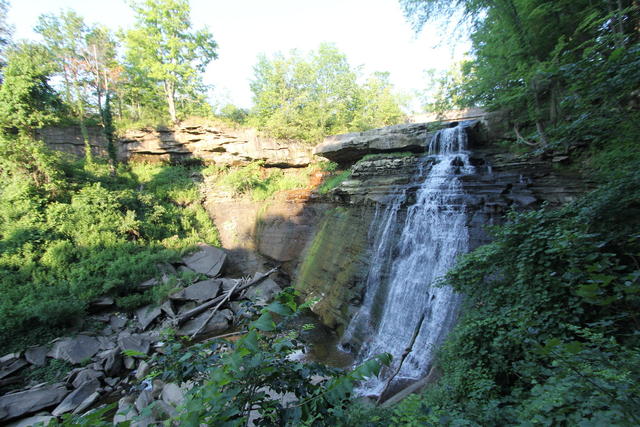 This waterfall in the Cuyahoga Valley National Park shows the more erosion-resistant upper layers and softer lower layers that create the uniquely steep topography that causes this region to contrast so much with the flatter surrounding regions. Photo © Betsy Weber, CC BY 2.0.
Plant Lists & In-Region Search
We do not yet have data to generate plant lists for a region as fine-tuned as this one. However you can move up to the broader Erie Drift Plain and generate lists for that region: native plants or all plants. Or search that region's plants here:
↑References
1. Woods, A.J, Omernik, J.M., Brockman, C.S., Gerber, T.D., Hosteter, W.D., Azevedo, S.H. "Ecoregions of Indiana and Ohio (Poster)", US Geological Survey (1998) Web.