
Home » Regions » North America » Eastern Temperate Forests » Mixed Wood Plains » Erie Drift Plain » Low Lime Drift Plain
Low Lime Drift Plain
Last updated: August 10th, 2020
↑About the Low Lime Drift Plain
The Low Lime Drift Plain is a region extending through much of northeast Ohio, northwest Pennsylvania, and the southwestern corner of New York State. "Low Lime" refers to the glacial drift here being low in calcium-rich minerals.This glaciated region is characterized by rolling terrain, broad valleys, and numerous local glacial features, including terminal moraines, kettles, and various wetlands of glacial origin. The substrate consists of glacial till on top of acidic sedimentary rock. The till here is clayey and loamy, and it is mixed with lake sediment and coarse outwash materials. Soils are typically rocky, poorly drained, and low in nutrients, but there is considerable local variability in soil type.
The climate is humid and continental. Most of this region is far enough from Lake Erie to experience little to no climate influence, but areas to the north of this region experience some moderation of climate as well as additional lake-effect precipitation.
The original forest cover was probably northern hardwood forest on better-drained sites, with dominant species being sugar maple (Acer saccharum), yellow birch (Betula alleghaniensis), American beech (Fagus grandifolia), and eastern hemlock (Tsuga canadensis), and beech-maple forest on more average-to-poorly-drained sites. In addition to forests, there were also marshes, swamps, and bogs. There are some examples of intact, undisturbed forests and wetlands in this region. At least two locally-endangered species can be found here in alkaline wet meadows.
Although the soils here are not particularly fertile or suited to Western agriculture, there is abundant dairy farming here. There is significant urbanization and suburbanization, and some industrial development, with this region including much of the eastern portion of the Cleveland metro area, the smaller city of Youngstown, OH, and part of the Erie, PA metro area. The rest of the region is more sparsely populated but still contains numerous small towns. Significant forest cover remains, mostly on rugged terrain such as gorges along larger streams, but remaining forests are highly fragmented by a dense network of roads as well as by agriculture, and tend to have irregular borders and a high proportion of edge habitats.
To the northwest, this region is bordered by the lake-moderated Erie/Ontario Lake Plain. To the west, this region is bordered by the more fertile but more poorly-drained Clayey High Lime Till Plains. At the southwest, the region borders the fertile, well-drained Loamy High Lime Till Plains. The border to the southeast is with the Unglaciated Upper Muskingum Basin in the west, and the Unglaciated High Allegheny Plateau farther east. The far northeast end of this region borders the Glaciated Low Allegheny Plateau to the east, and the southernmost end borders the Ohio/Kentucky Carboniferous Plateau to the south.
There are also several small regions contained within this one: near Cleveland, the Erie Gorges, and south of that, the Summit Interlobate Area. A much larger area interspersed throughout this one in northeast Ohio and northwestern Pennsylvania is the Mosquito Creek/Pymatuning Lowlands.
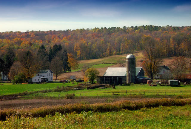 This photo shows a farmstead in Washington Township, Erie County, PA. The forested hill here is a drumlin, a glacial feature that can be found in this region. Photo © Nicholas A. Tonelli, CC BY 2.0.
Plant Lists & In-Region Search
We do not yet have data to generate plant lists for a region as fine-tuned as this one. However you can move up to the broader Erie Drift Plain and generate lists for that region: native plants or all plants. Or search that region's plants here:
↑References
1. Bryce, S.A., Griffith, G.E., Omernik, J.M., Edinger, G., Indrick, S., Vargas, O., and Carlson, D. "Ecoregions of New York (Poster)", U.S. Geological Survey (2010) Web.
2. Woods, A.J, Omernik, J.M., Brown, D.D. "Level III and IV Ecoregions of Delaware, Maryland, Pennsylvania, Virginia, and West Virginia", U.S. Environmental Protection Agency: National Health and Environmental Effects Research Laboratory, Corvallis, OR (1999) Web.
3. Woods, A.J, Omernik, J.M., Brockman, C.S., Gerber, T.D., Hosteter, W.D., Azevedo, S.H. "Ecoregions of Indiana and Ohio (Poster)", US Geological Survey (1998) Web.