
Home » Regions » North America » Eastern Temperate Forests » Southeastern USA Plains » Northern Piedmont » Piedmont Uplands
Piedmont Uplands
Last updated: July 21st, 2020
Page contents
↑About the Piedmont Uplands
The Piedmont Uplands stretches northeast-southwest in several discontinuous pieces from northern Virginia, through Maryland, and into south-central and southeast PA. The topography consists of rounded hills, low ridges, irregular plains, and narrow valleys, all underlain by metamorphic rock. Relief is high relative to areas south and east.The Susquehanna river, a wide, shallow river predating the rise of the Appalachians, cuts through this region, with steep cliffs at many locations along the river. At many locations, high-gradient streams flow into this river. Farther southwest, Potomac also flows through this region.
Varied geologic formations create diverse topography and habitat. Erosion-resistant quarzite and phyllite form the highest areas. Much of the area is underlain by schist and gneiss. Soil fertility is variable, much much of the region has deep soils well-suited to agriculture, except on areas underlain by quartzite where soils are shallow and rocky. Scattered outcroppings of serpentine, a mineral group low in plant nutrients but high in toxic metals like chromium and nickel, occur and create a unique habitat called serpentine barrens. These habitats contain rare and endemic species specialized to these conditions, together with grassland and savannah species normally only found in drier regions.
Originally, this area was mostly forested, with a few open savannahs in serpentine barrens. The forest was probably mostly Appalalchian Oak Forest, with northern red oak (Quercus rubra) and white oak (Quercus alba) as dominants, with some Mixed Mesophytic Forest. However, the diversity of substrates and topography led to many different forest types on different sites.
Forest cover today has been greatly reduced, primarily by agriculture, but also by urban development and industry. Although most of the forests have been cleared, a small amount of old growth forest remains in the Holtwood Environmental Preserve, including chestnut oak (Quercus montana), eastern hemlock (Tsuga canadensis), American beech (Fagus grandifolia), sugar maple (Acer saccharum), and American basswood (Tilia americana).
This area contains most of the Philadelphia metro area, as well as part of the metro areas of Baltimore and Washington D.C. Agriculture includes production of grain, potatoes, hay, poultry, and beef cattle. Remaining forest cover is disproportionately in more rugged areas, including both hills and areas where streams cut steep ravines into the landscape.
This region faces a complex series of environmental problems. Soil erosion due to traditional agricultural practices which leave little to no room for riparian buffers, is a major problem, causing soil loss in this region and nutrient pollution downstream in the Chesapeake bay. Much of this region also suffers from overpopulation of white-tailed deer, which thrive in suburban areas where they are protected from hunting. Deer overbrowsing hinders forest regeneration. There is also a high density of invasive plant species here, reflecting both non-native landscaping in suburban development, and the proximity to Philadelphia, which has historically been a major horticultural center, importing many plants from other continents.
The southeastern border of this region is marked by a fall line where the substrate switches to a softer sedimentary rock underneath. This marks the beginning of the coastal plain. To the north, this region is bordered by and somewhat interspersed with the Piedmont Limestone/Dolomite Lowlands, which is flatter, lower, and has much richer soils. Both to the north and interspersed with this region to the south, this region also borders the Triassic Lowlands, which is slightly lower and flatter and has somewhat richer soils. The southern portion of this region is bordered to the northwest by the Northern Igneous Ridges of the Blue Ridge.
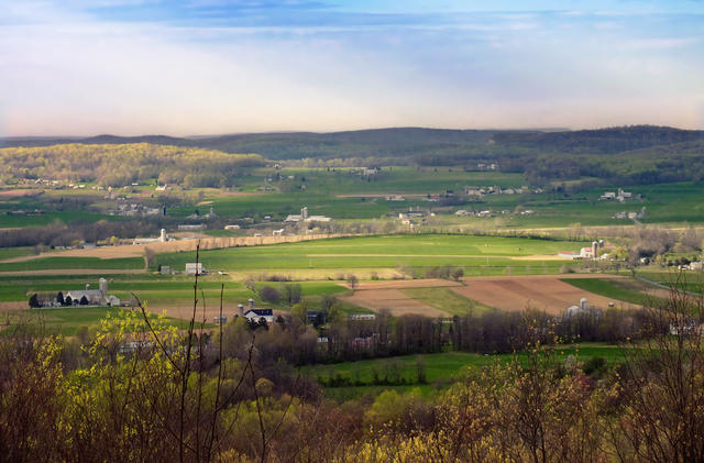 This view is taken from Money Rocks County Park in the Welsh Mountains, part of this region. It overlooks farmland also located in this region, showing the mosaic of land use typical here, with forested upland areas and lower areas mostly utilized for farming. Photo © Nicholas A. Tonelli, CC BY 2.0.
Plant Lists & In-Region Search
We do not yet have data to generate plant lists for a region as fine-tuned as this one. However you can move up to the broader Northern Piedmont and generate lists for that region: native plants or all plants. Or search that region's plants here:
↑References
1. Woods, A.J, Omernik, J.M., Brown, D.D. "Level III and IV Ecoregions of Delaware, Maryland, Pennsylvania, Virginia, and West Virginia", U.S. Environmental Protection Agency: National Health and Environmental Effects Research Laboratory, Corvallis, OR (1999) Web.