
Home » Regions » North America » Eastern Temperate Forests » Southeastern USA Plains » Northern Piedmont » Hackensack Meadowlands
Hackensack Meadowlands
Last updated: March 1st, 2021
Page contents
↑About the Hackensack Meadowlands
The Hackensack Meadowlands are a small, narrow region stretching from western Staten Island and Carteret, NJ, north and slightly east through the part of New Jersey nearest to New York City. This region exists entirely within the largest metro area in the U.S., and has thus been severely altered from its original state. This is one of the most degraded ecoregions in all of North America.This low-elevation region was once a glacial lake. At the time of European settlement it had a mix of salt marsh, brackish, and freshwater marshes. Much of the region is underlain by sand and peat atop clay deposits. The bedrock of sandstone, siltstone, and mudstone is buried and does not influence surface soils in most places. The area tends to be poorly-drained, both because of its soils and its flat topography. The climate is towards the colder end of a humid subtropical climate; precipitation is relatively constant year-round. Temperatures are moderated only slightly by the proximity to the ocean; severe cold is possible in some years.
The originally vegetation cover was a mix of Atlantic white cedar (Chamaecyparis thyoides) swamps, floodplain forests with pin oak (Quercus palustris), red maple (Acer rubrum), and swamp white oak (Quercus bicolor), and marshes mainly of broadleaf cattail (Typha latifolia). Salt-marshes featured saltgrass (Distichlis spicata), saltmeadow rush (Juncus gerardii), lavender thrift (Limonium carolinianum), and dwarf saltwort (Salicornia bigelovii), and seaside goldenrod (Solidago sempervirens).
Most of this area has been heavily urbanized, mostly in industrial development; the proximity to the largest metro area in the U.S. and the location of ports here make this area attractive to industry. Trash disposal is also one of the main land uses here. Drainage patterns have been altered by damming, filling, and channelization, usually with the intention of draining wetlands and creating more dry ground to build on. The extensive fill has caused the original substrate to sink much lower in many places. Surface soils nowadays are highly variable and are often formed on materials brought in from elsewhere.
The original forests here have been cleared. What remains of the marshes here are often dominated by common reed (Phragmites australis), with some smooth cordgrass (Spartina alterniflora) at tidal creek margins. Phragmites may benefit from the alteration of the ground here, as it can survive in slightly drier conditions than cattail. There are some forests and meadows, mostly highly fragmented, and also plant communities growing on waste ground.
There is some protected land here, mostly public, and a small amount of private land. New York City administers many parks and nature preserves in this region, including the William T Davis Wildlife Refuge, Meredith Woods, Saw Mill Creek Marsh, and Mariner's Marsh Park, all located on Staten Island, and also Pralls Island. New York State also owns the Old Place Creek Tidal Wetlands Area and the Goethals Pond Complex on Staten Island. There is less protected land on the New Jersey side, some along the Rahway River at the Hawk Rise Sanctuary and across the river at Joseph Medwick Park, some at Richard W. DeKorte Park, and at the Hackensack Meadowlands Conservation and Wildlife Area. The Meadowlands Conservation Trust also owns and manages 9 small properties here.
This region is surrounded on all sides by the Glaciated Triassic Lowlands, a region that tends to be higher in elevation and better-drained.
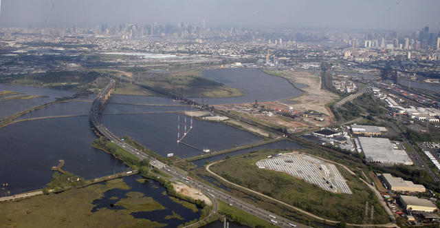 This scenery is typical of the Hackensack Meadowlands: wetland remnants among heavy industrial development. Much of the industry is built on landfill, and the wetlands have been extensively channelized, but much of the ground is still too wet to build on, and numerous tidal marshes still remain. Photo © Doc Searls, CC BY 2.0, Source.
Plant Lists & In-Region Search
We do not yet have data to generate plant lists for a region as fine-tuned as this one. However you can move up to the broader Northern Piedmont and generate lists for that region: native plants or all plants. Or search that region's plants here:
↑References
1. Woods, A.J., Omernik, J.M., Moran, B.C. "Level III and IV Ecoregions of New Jersey", (2007) Web.
2. Bryce, S.A., Griffith, G.E., Omernik, J.M., Edinger, G., Indrick, S., Vargas, O., and Carlson, D. "Ecoregions of New York (Poster)", U.S. Geological Survey (2010) Web.