
Home » Regions » North America » Eastern Temperate Forests » Southeastern USA Plains » Northern Piedmont » Glaciated Triassic Lowlands
Glaciated Triassic Lowlands
Last updated: July 22nd, 2020
Page contents
↑About the Glaciated Triassic Lowlands
The Glaciated Triassic Lowlands represents a more northerly counterpart to the same substrate on which the Triassic Lowlands are situated, but this region has been glaciated whereas the more southerly one was not.The terrain here is mostly flat but locally irregular, with depressions and low hills and ridges. The bedrock is Triassic sedimentary rock, but it is mostly covered by an extensive cover of till and drift left over from the recent Wisconsin glaciation. The till is derived from acidic red sandstone and shale, itself derived from Triassic sediments, and, in the northwest, till made of gneiss from the Northeastern Highlands. Both these types of till create acidic soils that are markedly less fertile than those formed from the sedimentary rocks of the unglaciated Triassic lowland regions. Soil textures vary considerably, as the till is a mixture of gravel, sand, silt, and clay; there are thus a mix of well-drained and poorly-drained sites throughout the region. A small area has some serpentine minerals that inhibit plant growth.
The region exists in a transitional zone between a humid continental climate, and a humid subtropical climate. There is some influence of storms coming from the ocean, but the ocean does not provide much moderating effect. Precipitation is roughly equally distributed year-round, and weather can vary considerably from year-to-year.
The original vegetation cover here is not well known, but this region was in a region broadly transitional from Appalachian Oak forests farther south and Northern Hardwood forests common in New England. On the drier sites it was probably a mix of oaks, including northern red oak (Quercus rubra), white oak (Quercus alba), and black oak (Quercus velutina), and also American chestnut (Castanea dentata) and hickories (Carya sp.) Moister sites, including valleys, sheltered ravines, and north-facing slopes supported northern hardwood forests with sugar maple (Acer saccharum), American beech (Fagus grandifolia), yellow birch (Betula alleghaniensis), and eastern hemlock (Tsuga canadensis). The portion of this region on Staten Island also had some serpentine barrens with savanna and grasslands. Poorly-drained sites supported red maple (Acer rubrum), American sweetgum (Liquidambar styraciflua), swamp cottonwood (Populus heterophylla), swamp white oak (Quercus bicolor), pin oak (Quercus palustris), and tupelo (Nyssa sylvatica).
This area is located entirely within the New York City metro area, mostly north and west of the city, and is heavily urbanized. It includes New Jersey's four largest cities: Newark, Jersey City, Paterson, and Elizabeth, and many other smaller ones. Very little wild forest cover remains, mostly a few small fragments at the northernmost and westernmost parts of this region where there is lower-density suburban development. There is also a small and rapidly decreasing amount of agriculture, now mostly surrounded by suburbs, producing crops and nursery stock. The low fertility of the soils combined with sprawling development here led agriculture to be abandoned quicker here than areas farther southwest or north.
This region surrounds the Hackensack Meadowlands in the east, and some areas of Passaic Basin Freshwater Wetlands in the west. It also borders Trap Rock and Conglomerate Uplands in several locations, and the unglaciated Triassic Lowlands to the south.
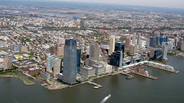 This photo of Jersey City, NJ, looking west and a little north, shows the densest part of the Glaciated Triassic Lowlands in the foreground, with less dense suburban development in the background. This region is flat and tends to be heavily urbanized. Photo © David Jones, CC BY 2.0, Source.
Plant Lists & In-Region Search
We do not yet have data to generate plant lists for a region as fine-tuned as this one. However you can move up to the broader Northern Piedmont and generate lists for that region: native plants or all plants. Or search that region's plants here:
↑References
1. Woods, A.J., Omernik, J.M., Moran, B.C. "Level III and IV Ecoregions of New Jersey", (2007) Web.
2. Bryce, S.A., Griffith, G.E., Omernik, J.M., Edinger, G., Indrick, S., Vargas, O., and Carlson, D. "Ecoregions of New York (Poster)", U.S. Geological Survey (2010) Web.