
Home » Regions » North America » Eastern Temperate Forests » Ozark, Oauchita-Appalachian Forests » Blue Ridge » Northern Sedimentary and Metasedimentary Ridges
Northern Sedimentary and Metasedimentary Ridges
Last updated: February 27th, 2020
Page contents
↑About the Northern Sedimentary and Metasedimentary Ridges
The Northern Sedimentary and Metasedimentary Ridges are one of the two northernmost subregions of the Blue Ridge. Along most of their length, they are the northwesternmost (more inland) of these two regions, and are narrower in most places. They extend from South Mountain, PA, briefly through Maryland and into Virginia, south to about Roanoke.This region consists of high ridges and narrow valleys, with steep slopes. Peak elevations are highest at the southern end, rising over 3,500 feet (1,067m) in Virginia. Tops of ridges tend to be regular and relatively flat, and the ridges tend to branch frequently, leading there to be numerous steep-walled valleys, roughly evenly spaced. These valleys tend to have a uniform appearance when viewed on a large spatial scale.
The bedrock consists of erosion-resistant sedimentary and metasedimentary rock from the Cambrian era. Soils tend to be rocky, acidic, and nutrient-poor.
Naturally, this area was covered in Appalachian Oak Forest, and it is still mostly forested today, owing in large part to its poor suitability for agriculture or urban development.
This region is bordered to the southeast by the Northern Igneous Ridges, sandwiching this region in a few areas. The border of these regions marks the border where igneous rocks contacted the older sedimentary rocks during the formation of the bedrock underlying these regions. Although the igneous ridges are slightly more rugged and higher in places, these two regions are more similar to each other than either is to any of their other bordering regions.
To the northwest, this region borders the fertile, low-lying Northern Limestone/Dolomite Valleys of the Ridge and Valley region along most of its length. At the very southern end it is bordered instead by the Southern Limestone/Dolomite Valleys and Low Rolling Hills, and in one place by the Southern Shale Valleys.
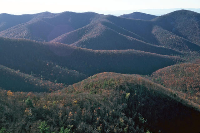 This photo, taken from the Rockytop Overlook on Skyline Drive, shows the gently-sloping and frequently-branching ridgetops that easily distinguishes this region from its igneous counterpart to the east. Between the ridges are numerous narrow, steep-walled valleys. Photo © Shenandoah National Park, Flickr, Public Domain, Source.
Plant Lists & In-Region Search
We do not yet have data to generate plant lists for a region as fine-tuned as this one. However you can move up to the broader Blue Ridge and generate lists for that region: native plants or all plants. Or search that region's plants here:
↑References
1. Woods, A.J, Omernik, J.M., Brown, D.D. "Level III and IV Ecoregions of Delaware, Maryland, Pennsylvania, Virginia, and West Virginia", U.S. Environmental Protection Agency: National Health and Environmental Effects Research Laboratory, Corvallis, OR (1999) Web.