
Home » Regions » North America » Eastern Temperate Forests » Ozark, Oauchita-Appalachian Forests » Southwestern Appalachians » Shale Hills
Shale Hills
Last updated: December 7th, 2020
Page contents
↑About the Shale Hills
The Shale Hills, sometimes also referred to as the Warrior Coal Field, is the southernmost region in the Southwestern Appalachians, a roughly triangular region located entirely within Alabama, and mostly drained by the Black Warrior River. It is mostly forested, but has a high density of open-pit coal mining which has degraded the environment, and the region has also suffered from the damming of rivers.This region is a moderately-dissected plateau, hillier than the table plateaus to the northeast, but less rugged than the areas directly to the north. Much of the region has relatively flatter uplands with some open hills, with numerous steep ravines descending into flat bottomlands along streams and rivers. The area is underlain by shale, siltstone, sandstone, and coal. These rocks are relatively impermeable to water, leading to a high density of surface streams.
This region was originally covered in mostly oak-hickory and oak-hickory-pine forest.
Presently this region is still mostly forested, but there is extensive coal mining, mostly open-pit mining that exposes soil. There are small amounts of agriculture, mostly on the broader bottomlands but also on some of the flatter portions of uplands as well. The region mostly produces hay and poultry, both for broilers and eggs.
The coal mines have exposed lower layers of soil with less-developed soil profiles, and have also resulted in problems with acid mine drainage. In addition to by mining, this region has also been altered by the damming of the Black Warrior River, creating Holt Lake at the lower border of this region, just before the fall line that marks the end of the Appalachians. This lake is also attached to other named lakes such as Bankhead lake upstream. This damming has flooded extensive bottomlands, and created miles of steep-walled zones that extend not only up the river, but well up many of its larger tributaries.
This region is bordered to the north by the Dissected Plateau, a region that is much more heavily-dissected, and where there are almost no flat uplands, only a landscape of winding and branching ridges. At the far southeast there is a small border with the Southern Table Plateaus, a region less dissected than this one, where the uplands are much flatter. The west and southwest border of this region is a fall line marking the end of the Appalachians, and the region is bordered by the Fall Line Hills, a lower-elevation region that is somewhat hilly, but less rugged than here. To the southeast, this region is bordered by the Southern Limestone/Dolomite Valleys and Low Rolling Hills of the Ridge and Valley system of the Appalachians.
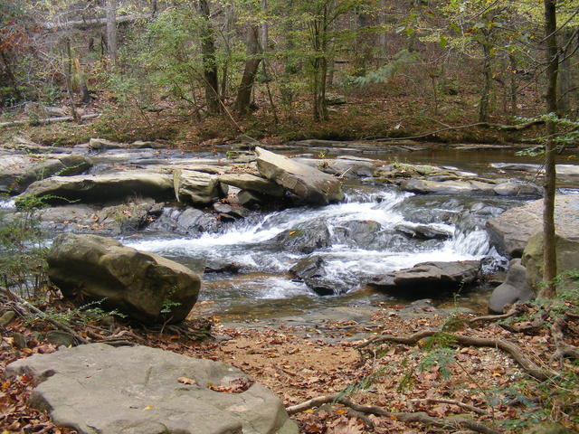 The Shale Hills are mostly underlain by rocks impermeable to water, leading to a high density of small surface streams like this one, Turkey Creek. Photo © André Natta, CC BY 2.0, Source.
Plant Lists & In-Region Search
We do not yet have data to generate plant lists for a region as fine-tuned as this one. However you can move up to the broader Southwestern Appalachians and generate lists for that region: native plants or all plants. Or search that region's plants here:
↑References
1. Griffith, G.E., Omernik, J.M., Comstock, J.A., Lawrence, S., Martin, G., Goddard, A., Hulcher, V.J., and Foster, T. "Ecoregions of Alabama and Georgia (color poster with map, descriptive text, summary tables, and photographs)", U.S. Geological Survey, Reston, VA (2001) Web.