
Home » Regions » North America » Eastern Temperate Forests » Southeastern USA Plains » Interior Plateau » Mitchell Plain
Mitchell Plain
Last updated: August 11th, 2020
Page contents
↑About the Mitchell Plain
The Mitchell Plain is an irregularly-shaped, relatively flat area stretching mostly north-south, located mostly in southern Indiana but also extending into Kentucky. This area is characterized by its karst topography, and is mostly rural and agricultural, although it has more residential development than the more rugged regions it is nestled between.The landscape here consists mostly of gently-rolling plains. There are abundant sinkholes, ponds, and springs, with wetlands formed in some of the sinkholes. Much of the drainage here is underground, and as such some of the valleys are dry, with no above-ground streams. Although most of the region was never glaciated, the northern end of this region was glaciated during pre-Wisconsinian glacial periods, causing it to be flatter and more poorly-drained. The bedrock here is almost exclusively limestone, although on a few isolated knobs in the west there are some other types of sedimentary rock. On top of this there is also loess and alluvium in the south, and in the north, colluvium. The soils here are fertile and well-suited to agriculture.
Original forest cover here was mostly Western mesophytic forest in the north, with numerous oaks. In the south, there was a mosaic of oak-hickory forest and bluestem prairie. Steeper slopes were dominated by oaks, whereas poorly-drained sites supported forests with pin oak (Quercus palustris) and sweetgum (Liquidambar styraciflua). There were also open wetlands, and some limestone glades and barrens on areas with exposed limestone bedrock, where little bluestem was also dominant.
Current land use is diverse, with significant cropland, residential development, and significant woodland. In the north, there are limestone quarries, and in the south, some of the land is used by the military. Agriculture here is diverse, producing corn, soybeans, livestock, small grains, and tobacco, and there is significant general farming. Woodland is more common on steeper sites, but there are small woodlots throughout. There is some public protected land along the Ohio river. Abandoned agricultural land supports initial growth of broomsedge, eastern eastern redcedar (Juniperus virginiana), black locust (Robinia pseudoacacia), and sumac, which develop into forests of redcedar and black locust.
The largest city here is Elizabethtown, KY. In spite of the close proximity to Louisville, KY, there is almost no suburbanization associated with that metro area, as that area has mostly expanded in other directions.
This area suffers from decreased water quality caused by a combination of municipal waste, agricultural runoff, and the removal of riparian forests along rivers and streams. In many places, croplands extend nearly the whole way to the banks of the Ohio river.
Along its entire length, this region is bordered to the east by the lower-elevation Knobs-Norman Upland; this border is irregular in shape but abrupt and well-defined, and is marked by the flat landscape giving way to steep gorges and a deeply-dissected landscape. The border to the west and south with the Crawford-Mammoth Cave Uplands, also extending along the full length of this region, is somewhat of an opposite: it is marked by the beginning of more rugged terrain, with hills significantly higher than this region. That border is less well-defined, as some of the lower hills are interspersed into this region. At the far north, this region also opens up into the Loamy High Lime Till Plains.
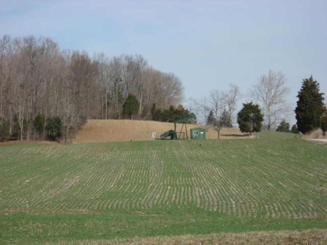 This winter landscape shows a scene typical of this region: gently rolling topography and a mix of cropland and forest. The abundance of eastern redcedar, a calcium-loving species, reflects the limestone soils. Photo © Nyttend (Wikipedia), Public Domain.
Plant Lists & In-Region Search
We do not yet have data to generate plant lists for a region as fine-tuned as this one. However you can move up to the broader Interior Plateau and generate lists for that region: native plants or all plants. Or search that region's plants here:
↑References
1. Woods, A.J, Omernik, J.M., Brockman, C.S., Gerber, T.D., Hosteter, W.D., Azevedo, S.H. "Ecoregions of Indiana and Ohio (Poster)", US Geological Survey (1998) Web.