
Home » Regions » North America » North American Deserts » Warm Deserts » Baja Californian Desert
Baja Californian Desert
Last updated: October 18th, 2023
Page contents
↑About the Baja Californian Desert
The Baja Californian desert, Spanish desierto bajacaliforniano is a region covering most of the Baja California peninsula, excepting the northernmost and southernmost tips. This region encompasses the driest portion of the Pacific Coast in the northern hemisphere, corresponding to the North Pacific High which pushes storms away from this region of coast.The region has a subtropical desert climate, ranging to semiarid at the highest elevations. Temperatures are seasonal with hot summers and cooler winters, but winters are usually frost-free except at the highest elevations. However, some of the interior low-elevation regions have rarely recorded temperatures well below freezing in an unseasonably cold winter. Due to cool ocean currents, temperatures on the Pacific Coast are cooler year-round than temperatures on the Gulf Coast, although the biggest temperature differences occur in summer, where both highs and lows may be as much as 10°F (about 5°C) lower on the Pacific side than the Gulf side; winter temperatures vary only by 1-2°F (about 1°C). Rainfall is low throughout most of the region, ranging from about 100mm (under 4 inches) annually to about 300mm (under 12 inches) at the highest elevations. Rainfall is strongly seasonal, with a summer rainy season peaking August-September, a winter rainy season from December through February, and a pronounced dry season with almost no rain from March through June. The north of the region has more Mediterranean climate influence, with over half the annual precipitation falling in winter. Moving south, winters become drier and summers wetter, and at the southern end, about 2/3rds of the rain falls in late summer. On average the center of the region is driest although rain is unpredictable and often patchy throughout the region in a particular year.
In spite of the low rainfall, there is often dense fog and average high relative humidity, staying between 60-70% in much of the region, and rarely dipping below 50%. In addition to surface fog, cloud cover in the hottest months is higher than in most regions with similarly low rainfall totals. The region is also subject to rare but sometimes severe tropical storms, which can dump more rain in a day than the region sees in an average year.
The terrain here ranges from totally flat in places to rugged in others, but overall, this region is more rugged than deserts to the northeast. The mountains here are geologically young, and rock outcroppings here are primarily of volcanic rock, although there are also sedimentary rocks that have been pushed to the surface in places. The highest elevations here, reaching to 1,940 m (6,360 ft), are found at Trés Vírgenes, a complex of three stratovolcanoes which have not erupted in thousands of years, but have erupted between 6,500 and 24,000 years ago. Another more rugged part of the region is Sierra de la Giganta, which reaches only to 3,858 ft (1,176 m). Parts of the region have dissected plateaus with relatively steep-walled canyons reaching 300m (nearly 1000 ft) or deeper. The young geologic history and arid climate combine to make the dissection and drainage network poorly developed in places.
There is little perennial surface water here, but there are numerous intermittent streams that form when there is heavy rainfall. The only perennial surface water is found as natural springs in canyons and lower slopes in the more mountainous areas, where the higher rainfall at higher elevations percolates into groundwater, forming a more stable water supply that then slowly seeps out of the rocks. The largest stream here, one of the few with perennial flow, is along the town of San Ignacio, and is spring-fed in this manner. Most of this region drains west into the Pacific, even in some areas surprisingly close to the Gulf, although there are some small regions where significant ephemeral streams drain into the Gulf.
The flora and overall vegetation cover of this region is extraordinarily unique owing both to its unusual combination of low rainfall and high relative humidity and fog cover, and its relative isolation, which has been consistent over its geologic history. The region has a high density of endemic species, some of which are relatively common here. Low elevations feature desert-like vegetation, with dominant plants including izcaíno agave (Agave vizcainoensis), cirio (Fouqueria columnaris), creeping devil cactus (Stenocereus eruca), sour pitaya (Stenocereus gummosus) and red barrel cactus (Ferocactus peninsulae). In the far north where there is more Mediterranean climate influence, there are some shrublands with a mix of thick-stemmed shrubs and cacti, and there are also more rosette shrubs. The central plains mostly feature microphyllous shrubs (with very narrow leaves) and more typical sandy desert vegetation. The density of rosette and shrub cover is higher than typical for regions with such low rainfall, due both to plants able to extract moisture from coastal fog, and from lower water loss due to higher relative humidity and to a degree, higher cloud cover in the hottest months. The highest elevations, particularly in canyons, support oak forests and tropical deciduous forests, and even outside these forested areas, rich and lush riparian vegetation and palm groves along the major drainage corridors and in spring-fed areas.
This area's isolation and sparse population has led it to be largely insulated from the human-induced environmental problems affecting other nearby regions, and this region remains one of the best-preserved ecoregions anywhere in Mexico as well as anywhere on the West Coast of North America and among any of North America's deserts. There is some mining, particularly of precious metals and some other metals. There is a small amount of agriculture made possible by aquifer-fed irrigation, producing wheat, sorghum, corn, chickpeas, cotton, citrus, and a variety of vegetables including asparagus, tomatoes, and chili peppers. There is also significant dairy production, as well as livestock, including pigs, cattle, chickens, and goats. Fishing has been historically important here, over time shifting slightly away from commercial fishing and more towards recreational or sport fishing; there is also some pearl harvesting. Tourism is also important, particularly in the coastal regions. Agriculture and fishing have been decreasing, whereas mining and tourism have been increasing. In recent years there has been an increase in ecotourism particularly. There are significant areas of protected land here, including El Vizcaíno Biosphere Reserve, the largest wildlife refuge in Mexico. The mostly-aquatic Bahía de Loreto National Park is found on the Gulf Coast, and encompasses several uninhabited islands as well as a variety of coastal habitats.
The largest city here, La Paz, has just over 250,000 residents, and lies near the southernmost end of the region. The next largest city, Ciudad Constitución, the main agricultural center, has just over 43,000 residents; there are a number of smaller cities, but most of the region is sparsely populated. Most of the water supply for these cities comes from aquifers and, even with the lower population here, is being used unsustainably. Water use per resident here is unnecessarily high in part because most water customers, including both residential and commercial, lack water meters and have no incentive to reduce usage. The region, especially La Paz, already faces periodic water shortages.
This region is bordered to the south by the Sierra and Plains of El Cabo, a small region making up the southernmost tip of Baja California Sur, and being mostly rugged, reaching to higher elevations, and having slightly higher rainfall in summer and supporting lusher growth of tropical dry forest. At the north end of this region, it is bordered to the northeast by the Sonoran Basin and Range, another warm desert region that is much flatter and faces more intensive land use and more severe environmental problems. To the northwest there is a border with the California Coastal Sage, Chaparral, and Oak Woodlands, which has a Mediterranean climate with wetter winters and drier summers. The border with the Sonoran Basin and Range is abrupt and well-defined, marked with a transition to extremely-flat plains, whereas the border to the northwest is more subjective and represents a gradual transition between subtly-differing climates.
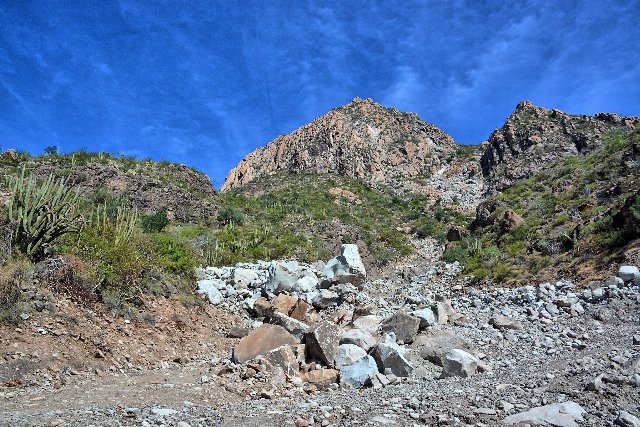 This photo shows the Sierra de la Giganta, one of the more rugged portions of the Baja California Desert. Although rainfall here is low, higher relative humidity and fog from the ocean combine to allow lusher vegetation growth than one might expect. Photo © Kirt Edblom, CC BY-SA 2.0, Source.