
Home » Regions » North America » North American Deserts » Warm Deserts
Warm Deserts
Last updated: October 24th, 2023
To check where a specific point lies, you can look it up in our Ecoregion Locator.
↑Map Legend & Subregion List
This list will help you navigate the regions in case you have problems with viewing or clicking the interactive map above.
| Name | † | Color on Map | CEC Code‡ |
| Mojave Basin and Range | ✓ | 10.2.1 | |
| Chihuahuan Deserts | ✓ | 10.2.4 | |
| Sonoran Basin and Range | ✓ | 10.2.2 | |
| Baja Californian Desert | ✓ | 10.2.3 |
† Status: ✓ = Complete ○ = Needs Image … = Incomplete ∅ = Stub Only
‡ This code refers to the CEC's Level 3 ecoregion codes for North America, see here.
↑Progress
Partially Complete | With Images | Complete w/ Images |
Get involved! You can help our ecoregion articles progress faster. Contact us if you have any additions or corrections to any of these articles. You can also donate to support our ongoing work.
↑About the Warm Deserts
The Warm Deserts are a region encompassing the warmer deserts in North America, consisting of two discontinuous pieces. The western portion extends from Nevada and southwest Utah through California and Arizona into most of Baja California and Sonora. The eastern portion is mostly located in Mexico, east of the Sierra Madre Occidental mountain range, extending north into west Texas and southern New Mexico.The climate here is arid and subtropical. There is significant seasonality to temperature but little frost: low elevations are mostly either frost-free or experience only occasional light frost, but temperatures can get colder at higher elevations. Unlike the Cold Deserts to the north which are mostly produced by rain shadow, this region, which opens to the ocean along its westernmost border, is heavily influenced by a persistent high-pressure system, the North Pacific High. This system diverts moisture-laden weather systems to the north and south as they come inland, which leads the deserts to extend the whole way to the Pacific coast in the central portion of this region. This region thus has a diversity of inland areas with drier air and more continental climate influence, to coastal areas with more moderate temperatures and higher relative humidity but very low rainfall. The Eastern portion of this region is influenced by a mix of of rain shadow, much like the cold deserts, and the effects of this high. This high pressure zone, which becomes stronger and moves north in the summer, and becomes weaker and moves south in the winter, leads there to be a seasonality of precipitation: the far northwest of this region receives more rainfall in winter, but the rest of the region receiving more rainfall in summer, with the effect becoming more pronounced moving farther south and east.
Vegetation cover varies considerably throughout this region. Some portions are dominated by large cacti, whereas in others, grasses are more dominant. Much of the vegetation is adapted to utilize short bursts of high water availability, going dormant for months at a time, and then becoming active in response to the presence of water. Plant diversity is often higher than in the cold deserts, owing to the greater portion of plants able to survive in the warmer temperatures, but the higher temperatures can also produce additional stress from heat and drought. Much of this region features low mountain ranges interspersed with the broad bottomlands; these areas of higher elevation also have higher rainfall and support denser vegetation cover, usually scrubland but reaching to forests in a few small regions along the highest peaks. These areas, owing to their isolation from other forested regions, have a high portion of endemic species.
Land use varies considerably throughout this region, with parts of it left largely untouched and ecologically preserved, and others of it intensely utilized and severely degraded. Major land uses here include ranching and grazing, irrigated agriculture, and mining. The irrigation for agriculture is both taken from major rivers, especially the Colorado river, as well as groundwater aquifers; both uses have large environment impacts. Historically, this region was sparsely populated, but more recently, the population has exploded in the major cities. The largest metro areas in this region include Phoenix, AZ, Las Vegas, NV, the cross-border metro of El Paso-Juaréz, and Torreón, Coahuila, Mexico. There are also numerous smaller cities and metro areas. Water diversion both for urban use and agriculture has severely reduced the flow of water in the major rivers of this region, especially the Colorado river, devastating the ecosystem in the Gulf of California. The Chihuahuan desert in the southeast is also facing increased human-induced desertification.
Different parts of this region border radically different ecoregions. To the west, this region transitions gradually into Mediterranean California, as the rainfall increases slightly and the desert becomes Chapparral. To the north, as temperatures cool, the western portion transitions smoothly to Cold Desert, but east of the rockies, the desert transitions to the relatively-moister South Central Semi-Arid Prairies. Southeast of the Sonoran desert, the region transitions to tropical dry forests of the Western Pacific Coastal Plain, Hills, and Canyons, and in Baja California, to the Sierra and Plains of El Cabo. Mountain ranges and changes in altitude produce more abrupt borders with the Western Sierra Madre Piedmont, and in the north, the Upper Gila Mountains.
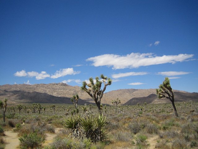 This photo shows two Joshua trees (Yucca brevifolia) in a landscape of mostly low grasses. The Warm Deserts in North America are sparsely-vegetated but have some unique plants like these that cannot survive in colder regions. The landscape in these deserts alternates between flat basins like in the foreground, and more rugged hills and low mountains like in the distance. Photo © Eric Titcombe, CC BY 2.0, Source.
Plant Lists & In-Region Search
List Native Plants - List All Plants
Warning! This region extends outside the lower 48 US. We have only completed range maps for all plants in the lower 48 US; these lists and searches may thus have omissions for species which only occur in the portion of this region outside the lower 48 US.