
Home » Regions » North America » Mediterranean California » California Coastal Sage, Chaparral, and Oak Woodlands
California Coastal Sage, Chaparral, and Oak Woodlands
Last updated: November 9th, 2023
To check where a specific point lies, you can look it up in our Ecoregion Locator.
↑Map Legend & Subregion List
This list will help you navigate the regions in case you have problems with viewing or clicking the interactive map above.
† Status: ✓ = Complete ○ = Needs Image … = Incomplete ∅ = Stub Only
‡ This code refers to the US EPA's Level 4 ecoregion codes for the continental U.S., see here.
↑Progress
Partially Complete | With Images | Complete w/ Images |
Get involved! You can help our ecoregion articles progress faster. Help us find photos of these regions. Contact us if you have any additions or corrections to any of these articles. You can also donate to support our ongoing work.
↑About the California Coastal Sage, Chaparral, and Oak Woodlands
The California Coastal Sage, Chaparral, and Oak Woodlands are a region located in coastal California, south into northern Baja California, and extending farther inland in northern California, surrounding the central valley.This region is treated inconsistently by different authorities. The CEC's regional classification treats it as one region, code (11.1.1), named California Coastal Sage, Chaparral, and Oak Woodlands This region is made of two discontinuous chunks, which the US EPA breaks into two regions, the Central California Foothills and Coastal Mountains (code 6), located entirely in the U.S., and farther south, the Southern California/Northern Baja Coast (code 85), located both in the U.S. and Mexico. Here we treat these all as a single region.
This region has a Mediterranean climate with mild, wet winters and dry summers. The dry season becomes longer, and total precipitation decreases as one moves south. The coastal mountain ranges also reach higher elevations in the south of this region, causing this climate zone to be limited to the coast, whereas farther north, the higher total precpitation combined with lower coastal mountain ranges leads this region to extend farther inland, entirely surrounding the central valley. Along the coast, fog provides some moisture, and high relative humidity and extensive cloud cover reduces evapotranspiration, allowing for lusher plant growth than would normally occur in a region with as little rainfall as this one. Summers are warm and moderate along the coast, but summers inland around the central valley, especially east of the valley, are much hotter.
Throughout this region, weather, including both precipitation and temperature, varies a lot by microclimate from site to site; more so in this region than in others, this variation is large relative to daily or weekly variation. Higher elevations bring higher rainfall and also more variation in temperature between day and night. Slopes facing the ocean and flat areas bordering the ocean are also noticeably more moderate and have higher humidity than areas inland. Small-scale rain shadow creates some inland valleys slightly drier than coastal areas. Overall, the weather here tends to be very predictable with little variation day-to-day or week-to-week, although this variation becomes greater farther from the ocean and at higher elevations.
Terrain here is mostly either highly rugged, with steep hills or low mountains, or nearly level, including both higher-elevation terraces and flat bottomlands. There is usually an abrupt separation from steep areas and flat areas, with little intermediate terrain, although there are a few areas of gently-rolling hills. Most streams are seasonal, but some perennial streams originate farther east, in wetter, higher-elevation regions.
Original vegetation here was mostly chaparral and open oak woodlands, with a few grasslands at the lowest elevations, especially in the drier south, and pines at highest elevations. Small areas of torrey pine (Pinus torreyana) occur near San Diego, remnants of an older ecosystem that has declined in extent even before human influence. Canyons and moist riparian areas have richer woodlands. The chaparral historically experienced infrequent (at most every 20-30 years, often much less often), but severe crown-destroying fires, usually occurring during late summer or fall, towards the end of the dry season.
This area is the most populous part of Mediterranean California, containing nearly the entirety of the four largest metro areas, in decreasing order of size: Los Angeles, The (San Francisco) Bay Area, Riverside-San Bernardino, and San Diego/Tijuana. There are also numerous smaller cities throughout, and extensive suburbanization. There is some agriculture, although much less than in the central valley. Agriculture here is diversified, growing a variety of fruits and vegetables as well as nursery products. There is also a small amount of livestock grazing. With very few exceptions, both urban areas and agriculture is limited to the broad, flat valleys. The scarcity of flat land in much of this region has placed intense pressure for development on this land; more rugged terrain such as mountains and canyons, difficult to build on or utilize for agriculture, has a greater portion of its original cover intact. There is almost no wild land left in the flat areas.
The fire frequency in this region has increased due to human influence, largely in attempts to protect the urban development here, which can be threatened by the more severe natural fires. Humans have also shifted the fire regime here to low-intensity, cool-season prescribed burns, which are often carried out much more frequently than natural fires. These end up threatening the ecosystems here, which are adapted to infrequent but more severe fires. Frequent fire does not give the chaparral time to regenerate, and leads to the dominance of invasive grasses and herbaceous plants.
In the north, this area completely surrounds the flatter, drier, more agricultural Central Californian Valley. North along the coast, as precipitation gradually increases, this region transitions into the wetter, more forested Coast Range; to the south along the coast, precipitation decreases and this region transitions into the Baja Californian Desert. Also in the north, this region is bordered to the east by the Sierra Nevadas and to the north by the Klamath Mountains/California High North Coast Range. In the south, the region is bordered inland and at higher elevations by the Southern California Mountains, and east past that, by the Sonoran Basin and Range in the southernmost parts, and the Mojave Basin and Range slightly north of that. The southermost portion of this region is bordered to the south by the Baja Californian Desert, a desert with very low rainfall but high relative humidity and fog/cloud cover much like coastal parts of this region.
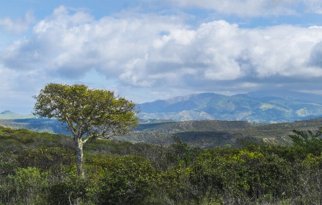 This landscape at Fort Ord National Monument shows one of the better-preserved areas of chaparral, showing mostly dense growth of shrubs and only one isolated tree. The terrain here is consistently hilly, like much of the California Coastal Sage, Chaparral, and Oak Woodlands. Photo © Bureau of Land Management California, Public Domain, Source.
Plant Lists & In-Region Search
List Native Plants - List All Plants
Warning! This region extends outside the lower 48 US. We have only completed range maps for all plants in the lower 48 US; these lists and searches may thus have omissions for species which only occur in the portion of this region outside the lower 48 US.
↑References
1. Wiken, E., Griffith, G. "North American Terrestrial Ecoregions - Level III", Commission for Environmental Cooperation, (2011) Web.