
Home » Regions » North America » North American Deserts » Warm Deserts » Sonoran Basin and Range
Sonoran Basin and Range
Last updated: October 23rd, 2023
To check where a specific point lies, you can look it up in our Ecoregion Locator.
↑Map Legend & Subregion List
This list will help you navigate the regions in case you have problems with viewing or clicking the interactive map above.
† Status: ✓ = Complete ○ = Needs Image … = Incomplete ∅ = Stub Only
‡ This code refers to the US EPA's Level 4 ecoregion codes for the continental U.S., see here.
↑Progress
Partially Complete | With Images | Complete w/ Images |
Get involved! You can help our ecoregion articles progress faster. Help us find photos of these regions. Contact us if you have any additions or corrections to any of these articles. You can also donate to support our ongoing work.
↑About the Sonoran Basin and Range
The Sonoran Basin and Range, referred to both commonly and in many documents as the Sonoran Desert, Spanish desierto sonorense, is part of the Warm Deserts extending from the southeasternmost corner of California through much of southwestern Arizona, and, in Mexico, into southeastern Baja California, through much of Sonora and with a small discontinuous piece stretching into Sinaloa. This region suffers from severe environmental degradation due to use of nearly all of the water here for intensive agriculture, and in recent years, a huge surge in urbanization.This region consists of large, flat basins and scattered low mountains, to over 1,400 meters (about 4,600 feet.) There are some long fault-block mountain ranges, and there is also an active volcanic field, El Pinacate, which has mostly dormant volcanoes. Mountains in the west of this region are heavily faulted and consist of mounds of precariously stacked boulders, as earthquakes have broken the rock faster than it weathers. Streams are mostly ephemeral and there is little surface water throughout the region, but the streams have formed alluvial fans and other alluvial deposits where they flow out into valleys. The Colorado river flows through this region and much of the region drains into its watershed, but there are also some endorheic basins into which water drains with no outflow, including the Salton Sink.
The region mostly has a subtropical desert climate; average and minimum temperatures are significantly higher than the regions to the north, but the temperatures are somewhat moderated and record highs are not as high as in the hottest regions farther north. Significant areas are frost-free year-round, whereas other parts of the region have a frost-free period of at least 200 days. Precipitation is low, with the lowest elevations receiving as little as 75mm (under 3 in) of rainfall annually; the highest peaks receive about 560mm (22 in) but such areas are scattered and cover a tiny portion of this area. Winter rainfall is highest in the west, driven by storms moving in from the ocean, whereas summer rainfall is highest in the east, resulting from more southerly storms pushed north and inland as part of the North American monsoon.
The vegetation cover ranges from totally barren with exposed sand dunes in places, to microphyllous shrubs (shrubs with very narrow leaves having only a single vein), to various cacti. Cacti are more abundant here than in areas farther north. Dominant species include (Parkinsonia sp.), saguaro (Carnegiea gigantea), creosote bush (Larrea tridentata), white bursage (Ambrosia dumosa), ocotillo (Fouquieria splendens), brittlebush (Encelia sp.), catclaw acacia (Senegalia greggii), cholla (Cylindropuntia sp.), and cattle saltbush (Atriplex polycarpa), prickly pear (Opuntia sp.), desert ironwood (Olneya tesota), and mesquite (Prosopis sp.) The southern portion of this region has more tropical species in common with deciduous thorn forests. Unlike areas farther north, even the highest elevations here do not support tree cover, only scattered shrubs. However, historically this region had more tree cover, mainly along springs and seeps, which have been greatly reduced by depletion of groundwater through well digging.
The riparian area along the Colorado river used to support extensive forests of cottonwood and willow, and the mouth of the Colorado river had extensive areas of freshwater, brackish, and tidal marshes, once covering an area of about 7,810 square kilometers or 1.93 million acres. This area was extraordinarily rich in biodiversity and has been almost completely destroyed; currently less than 5% of the original extent of wetlands exist, but what little area is still left is mostly dominated by invasive species, including tamarisk (Tamarix sp.), and some native species previously found mainly in other areas, including arrowweed (Pluchea sericea) and iodine bush (Allenrolfea occidentalis). Although the Delta area is in theory protected as the Biosphere Reserve of the Upper Gulf of California & Colorado River Delta, little conservation can be achieved without the flow of fresh water.
Another unusual feature here is the Salton Sea, a body of water that was formed as the result of an accident in 1905, when spring flooding caused water from the Colorado River to break through an irrigation canal and flow into the Salton Sink. In recent time, this same space had sometimes been occupied by a natural lake, Lake Cahuilla, a lake which formed repeatedly due to flooding of the Colorado river, and then would dry up over a period of many years. The lake's most recent disappearance was shortly after 1580. The accidental formation of the Salton Sea in some respects resembles the natural flooding that created Lake Cahuilla. The presence of a body of water here moderates the climate of the surroundings somewhat, and the lake also supports an extensive bird population, even though the water itself is extraordinarily polluted due to fertilizer runoff and eutrophication. The lake had previously supported a much higher amount of diversity but a combination of agricultural pollutants and increasing salinity led to most of the lake's fauna to die off by the 1970's.
Land use is unusually intense here for a desert region. There are extensive areas of irrigated cropland. Although such cropland covers large areas on both sides of the US-Mexico border, because the US uses up most (about 90%) of the water in the Colorado river, the agriculture is much more intensive on the US side. Mexico then uses up nearly all of the remaining water, leaving almost none to reach the river's mouth. Agriculture here is diversified, with cropland producing cotton, feed crops such as alfalfa and hay, and fresh produce including lettuce, melons, onions, sweet corn, citrus fruits, and winter vegetables. Sorghum is the only grain produced here in significant quantities.
Fishing is important in Mexico's portion of this region, and the fishing industry has been decimated by the collapse of the ecosystem at the Colorado River Delta and upper portion of the Gulf of California, which used to be brackish water but has now become nearly as salty as the Pacific Ocean. There is a small amount of livestock grazing, which is mostly intermittent, only carried out temporarily during wetter periods, although there are a few cattle feedlots. There are also some areas used for military training, and there is some protected public land, in the US as national monuments, national parks, and national wildlife refuges, and in Mexico a large biosphere reserve near the mouth of the Colorado River. There are also some Native American reservations.
This area is also extensively urbanized. Phoenix, AZ is the largest city with a metro area of nearly 5 million people; Tucson, AZ and Mexicali, Baja California, are medium-large cities with metro areas over 1 million, and Hermosillo, Soonra, is nearly as large. There are also numerous small cities throughout, but outside of the urban areas the region is mostly unpopulated. In the US in particular, these cities are low-density and built to be heavily dependent on car use. The high population and car use, intensive agriculture creating toxin-laden dust, combined with low vegetation and high temperatures, and weather patterns and topography that lead air masses to stably settle in this area for long periods of time, all combine to make this area have some of the worst air pollution of any region in the interior southwest. This region also contains portions of a recently-constructed border wall which has caused significant environmental impacts, including disruptions to water drainage, blocking of migratory wildlife, and clearing of vegetation.
This region is bordered to the northwest by the Mojave Basin and Range, another desert region that is slightly higher-elevation and cooler, and has fewer cacti as a result. To the west, this region is bordered in most places by the California Coastal Sage, Chaparral, and Oak Woodlands, a region that has slightly higher rainfall, lusher vegetation cover, and is towards the dry end of a Mediterranean climate. At higher elevations, however, there are a few places where this region directly borders the Southern California Mountains to the West, a region with slightly more rainfall although still significant Mediterranean influence to the climate. On the west side of the Gulf of California, this region is bordered to the south by the Baja Californian Desert, another very dry desert but with more unique flora. In Arizona, this region is bordered to the northeast by the Upper Gila Mountains, a higher-elevation, cooler region with higher rainfall and more forest cover. To the east, this region is bordered by the Madrean Archipelago, a region of semi-arid highlands dominated by grasslands, wetter than this region but drier than the mountains to the north. On the east side of the Gulf of California, this region is bordered to the southeast by the Western Pacific Coastal Plain, Hills, and Canyons, a region of Tropical Dry Forests with wet summers and dry winters; specifically, this region is bordered along the coast by the Sinaloa Coastal Plain with Low Tropical Thorn Forest and Wetlands, and farther inland, by the Sinaloa and Sonora Hills and Canyons with Xeric Shrub and Low Tropical Deciduous Forest.
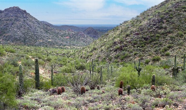 This landscape shows a protected portion of the relatively-lusher eastern portion of the Sonoran Desert, featuring the iconic saguaro cactus. The terrain varies between flat basins and low mountains. Warm temperatures allow cacti to thrive, but lack of water makes it so that even higher elevations are devoid of trees. Photo © kinglear55 (Flickr), CC BY 2.0, Source.
Plant Lists & In-Region Search
List Native Plants - List All Plants
Warning! This region extends outside the lower 48 US. We have only completed range maps for all plants in the lower 48 US; these lists and searches may thus have omissions for species which only occur in the portion of this region outside the lower 48 US.
↑References
1. Wiken, E., Griffith, G. "North American Terrestrial Ecoregions - Level III", Commission for Environmental Cooperation, (2011) Web.