Home » Regions » North America » Tundra » Alaska Tundra » Bristol Bay-Nushagak Lowlands
Bristol Bay-Nushagak Lowlands
Last updated: October 25th, 2024
Page contents
↑About the Bristol Bay-Nushagak Lowlands
The Bristol Bay-Nushagak Lowlands are a region in southwestern Alaska surrounding Bristol Bay and extending along the flatter, north slope of the Alaska Peninsula. Although our classification scheme places this ecoregion in the tundra, it is towards the warmest end of the tundra and has relatively more woody plants. This region was almost entirely glaciated relatively recently.The climate is usually classified as subarctic and continental, but the region has substantial maritime influence leading to cooler summers, warmer winters, higher cloud cover, and less variability than typical for subarctic climates. The moderating oceanic influence is strongest in the southwesternmost portion of the region, grading towards the climate of the Aleutian Islands, whereas the more inland portions of this region have greater continental influence. In the northeast of this region, the mountains to the southeast block air from the warmer Gulf of Alaska, leading this region to be considerably colder than areas, such as Kodiak Island and the Cook Inlet, on the other side of those mountains. In winter, Arctic sea ice tends to reach southward along the Alaskan coast to well past Bristol bay, although the extent varies from year to year. In the coldest years, the entire pay is frozen to quite far west along the Alaskan Peninsula, whereas in other years the ice does not extend very far past the bay. The extent of sea ice has been decreasing due to global warming, but is still irregular from year to year.
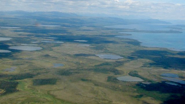
The terrain ranges from almost completely flat to gently rolling, with most of the topographic features glacial in origin, including moraines and outwash fields. Some of the underlying material here is of marine origin, from earlier periods where this region was underwater, but these are mixed with glacial till and outwash, and alluvial soils deposited by rivers and streams, and in much of the area, these materials are covered by finer-textured, wind-blown loess. There are only small, scattered areas of permafrost; much of the area is free of permafrost. There can thus be considerable diversity in the texture of surface soils, but overall, soils tend to be better-drained than colder areas where permafrost is more common and majorly impedes drainage. The drainage here was still disrupted by glaciers, however, and there are numerous small ponds and open wetlands throughout, although less than in the Subarctic Coastal Plain farther northwest. Alaska's two largest lakes are located at the eastern border of this region, Iliamna Lake and Becharof Lake.
The dominant vegetation cover is of low, dwarf shrub growth, including crowberry, labrador tea, various willow, birch, and alder, and abundant lichens and mosses. Poorly-drained sites support scrub bogs and other open wetlands. Although most of the area is covered by low, open scrub, there are a few local sites supporting open forests.
This area is sparsely populated, but there are some permanent settlements along the coast, the largest of which is Dillingham with over 2,000 people. Although a few small settlements, including Dillingham, have small road systems, they are not connected to each other or the rest of the state, and most of the region is devoid of roads. Long-distance travel here occurs only by boat or air. The total population here is only several thousand. The economy centers on fishing, with subsistence and recreational hunting and fishing throughout, and some commercial fishing along the coast. Although there has been some proposed mining of gold, copper, and molybdenum in the Pebble Mine project, the community and fishing industry here organized to block the project, citing concerns about negatively affecting the watershed, and it was blocked by actions of the US Army Corp of Engineers and the US EPA.
This region is bordered to the southeast by the higher-elevation, more rugged Alaska Peninsula Mountains. Along the coast to the northwest, it is bordered by the Ahklun and Kilbuck Mountains, which are also higher and more rugged. Inland to the northeast, this region is bordered by the Interior Forested Lowlands and Uplands, a diverse region that tends to be a bit better drained and less shaped by glaciers. All three of these bordering regions support more growth of woody plants and trees in some areas. None of these borders are well-defined; all represent gradual transitions with a somewhat subjective cutoff. The southwesternmost end of this region is near, but does not border the Aleutian Islands to the west; the Aleutian islands are more similar to the Alaska Peninsula Mountains than to this region, due to their rugged topography.
 This aerial photo of the Alaska Coastline somewhere between Ugashik and Naknek shows a landscape typical of the Bristol Bay-Nushagak Lowlands. The landscape is flat and there are numerous ponds; most of the vegetation cover is low and open tundra, although there are some areas of trees. The hills in the distance are the Alaska Peninsula Mountains. Crop and color-edit of a photo © Emma Forsberg, CC BY-SA 2.0, Source.

