
Home » Regions » North America » Northwestern Forested Mountains » Western Cordillera » Canadian Rockies
Canadian Rockies
Last updated: December 31st, 2022
To check where a specific point lies, you can look it up in our Ecoregion Locator.
↑Map Legend & Subregion List
This list will help you navigate the regions in case you have problems with viewing or clicking the interactive map above.
| Name | † | Color on Map | EPA Code‡ |
| Northern Front | ○ | 41a | |
| Crestal Alpine-Subalpine Zone | ○ | 41b | |
| Western Canadian Rockies | ○ | 41c | |
| Southern Carbonate Front | ○ | 41d | |
| Flathead Thrust Faulted Carbonate-Rich Mountains | ○ | 41e |
† Status: ✓ = Complete ○ = Needs Image … = Incomplete ∅ = Stub Only
‡ This code refers to the US EPA's Level 4 ecoregion codes for the continental U.S., see here.
↑Progress
Partially Complete | With Images | Complete w/ Images |
Get involved! You can help our ecoregion articles progress faster. Help us find photos of these regions. Contact us if you have any additions or corrections to any of these articles. You can also donate to support our ongoing work.
↑About the Canadian Rockies
The Canadian Rockies are a linear, northwest-southeast oriented region of the Rocky Mountains, extending from northwest Montana north through southwestern Alberta and southeastern British Columbia, encompassing most of the irregular, diagonal portion of the border between AB and BC. Along their length, this region makes up the easternmost and inlandmost portion of the Rockies, sheltered from the climate effects of the Pacific ocean. There is some degree of rain shadow here too, although this effect is less than in areas farther south.The climate here is humid and continental, tending towards subarctic at higher elevations. There is no moderating effect of the ocean, and the region is subject to unpredictable swings of temperature at any time of year. Precipitation is weakly seasonal in the south, with a short wet season in May-June, rainfall peaking well before temperature peaks; moving north through this region, the seasonality weakens and the entire warm season brings roughly even precipitation, with precipitation following only the trend of temperatures. Isolated permafrost can be found at the highest elevations.
The terrain consists of long mountain ranges with steep slopes, often with dramatically steep rock faces. Most peaks and ridges are bare, with exposed rock outcroppings, and often surrounded by extensive talus slopes and colluvium, as well as exposed glacial moraines. Cold temperatures and, on most sites, steep terrain slow and limit soil development, with most soils being poorly-developed; the richest soils tend to be found in the warmer, flatter valleys.
Open meadows and alpine tundra cover much of this region, but the lower elevations that are more forested support mostly-coniferous forests with lodgepole pine (Pinus contorta), Engelmann spruce (Picea engelmannii), and subalpine fir (Abies lasiocarpa). Some of the warmest, driest parts of this region, along the major valleys, support Douglas fir (Pseudotsuga menziesii) and quaking aspen (Populus tremuloides), opening into grasslands in places. Rock outcroppings at higher elevations also support some limber pine (Pinus flexilis). The alpine vegetation consists mostly of heather, sedges, and mountain-avens (Dryas sp.)
The majority of this region exists as protected public land, mostly as Canadian national parks, where there is significant tourism and recreation. Outside the parks, land utilization includes hunting, particularly of large game, and some forestry and natural resource exploration. Most of the region is sparsely populated, but there are a number of small towns throughout, the largest of which is Banff, Alberta. Other sizeable towns in Alberta include Jasper, Grande Cache, and Lake Louise, and in British Columbia, Invermere and Golden. The largest population center is in British Columbia near the western border of this region, along the corridor where Canadian Highway 93 runs, called the Columbia Valley, part of the Rocky Mountain Trench. Overall, this region is relatively accessible given its steep topography and northerly location, owing to the presence of numerous broad valleys throughout, which facilitates roadbuilding.
Over its length, this region is bordered to the west by the Northern Rockies, a similar mountainous region that has more influence from the Pacific ocean and thus higher rainfall. At the northern end this region is bordered to the northwest by the Skeena-Omineca-Central Canadian Rocky Mountains, and at its southern end it is bordered to the south by the Middle Rockies, a region in which the mountain ranges extend in more irregular directions and there are numerous isolated mountains and ranges. In the north of this region, it is bordered to the east by the Boreal Plain, a relatively flat region covered in boreal forest. Farther south, there is a small border to the northeast with the Temperate Prairies, and south of that, a larger border to the east with the West-Central Semi-Arid Prairies; these flat regions are drier and predominately covered in grasslands.
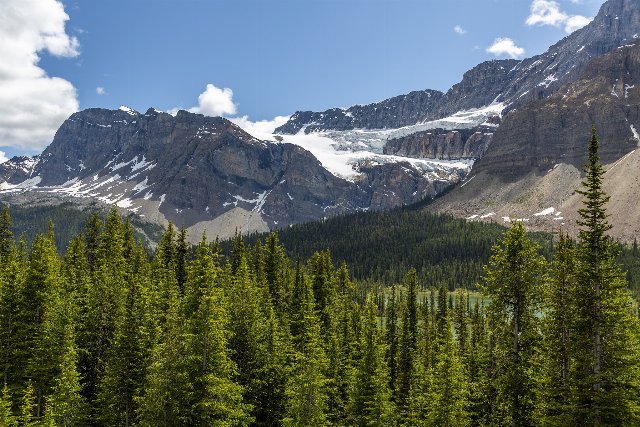 This photo from Banff National Park in Alberta shows a landscape typical of the Canadian rockies, with coniferous forests at lower elevations, and long, high ridges of mountains with dramatic, steep slopes showing exposed rock faces. Photo © Richard Ricciardi, CC BY 2.0, Source.
Plant Lists & In-Region Search
List Native Plants - List All Plants
Warning! This region extends outside the lower 48 US. We have only completed range maps for all plants in the lower 48 US; these lists and searches may thus have omissions for species which only occur in the portion of this region outside the lower 48 US.