
Home » Regions » North America » Marine West Coast Forest » Pacific and Nass Ranges
Pacific and Nass Ranges
Last updated: August 29th, 2024
Page contents
↑About the Pacific and Nass Ranges
The Pacific and Nass Ranges constitute a region of tall mountains in British Columbia located near, but not directly adjacent to the coast. This region has some of the tallest and widest sections of mountains on the West Coast and has the largest temperate icecaps anyhere in the world.The climate here varies widely with elevation, ranging from an oceanic climate in the west of the region at low elevations, though subarctic climates at mid-elevation, to a tundra climate at high elevations. In the inland portions of this region, the valleys have a climate towards the cold end of a humid continental climate.
This region consists of high, irregular, steep-sloped mountains. The highest peaks are surrounded by extensive ice fields, with glaciers reaching to lower elevations in places, but not quite reaching to sea level. The large valleys here were formed by glaciers; the valleys open into large inlets, forming steep-walled fjords in places. There is a moderate density of rivers, all generally flowing southwest into the Pacific; the largest of these is the Fraser. Most rivers tend to be short but carry a large volume of water relative to their length, reflecting a combination of the high precipitation and steepness of the topography.
Only the lower elevations here are vegetated. The lowest elevations along the coast, up to about 900m (2952ft) features dense coniferous forest of western hemlock (Tsuga heterophylla), western redcedar (Thuja plicata), and Pacific silver fir (Abies amabilis). Drier sites at low elevations, more common inland, feature western hemlock and douglas fir (Pseudotsuga menziesii). The next zone, to about 1,800m (5,906ft) features mostly mountain hemlock (Tsuga mertensiana) and Pacific silver fir with some alaska cedar (Callitropsis nootkatensis). There is a small zone of alpine meadows and tundra-like plant communities, with barren rock outcroppings, glaciers, and ice fields at the highest elevations.
This region is intensely utilized for forestry, and has some of the most productive forests anywhere in Canada, producing both pulp and sawlogs. There are also numerous hydroelectric plants here, which produce more electricity than most dams due to the high volume of water flowing through this region, and supply population centers elsewhere. There is a small amount of water-oriented recreation and tourism. Most of this region is essentially unpopulated, but there are numerous towns along the highway 99 corridor extending from Vancouver and through this region.
In the south, this region is bordered to the south and southwest by the lower, flatter, and much more populous Puget Lowlands / Georgia Depression, a region that has more moderate temperatures and more plant diversity. Over the rest of its length, it is bordered to the west by the lower, ocean-moderated Coastal Western Hemlock-Sitka Spruce Forests. At its northern end, it is bordered to the northwest by the Pacific Coastal Mountains, which can be seen as a colder, more northerly extension of this region; this border represents a gradual transition.
To the east, this region tends to border regions that are lower, relatively flatter (but still irregular to rugged in places), and drier, and have more continental influence of climate. At the southern end, the border to the east is with the Thompson-Okanagan Plateau, the driest and most populous of these regions. North of that, it is bordered to the east by the Chilcotin Ranges and Fraser Plateau, and still north of that, by the Skeena-Omineca-Central Canadian Rocky Mountains. The east-west border between this region and those is relatively well-defined geologically, but the borders between the three regions represent gradual transitions of climate with more arbitrary borders.
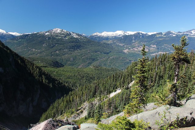 This photo shows a landscape at Garibaldi Provincial Park, towards the southern end of this region, taken at the end of summer. Even this far south, the highest elevations are covered in snow. Typical of this region, the terrain is steep and covered by dense coniferous forests at low elevations, and opening to rock outcroppings and alpine meadows in a narrow zone under the snow caps. Photo © heipei (Flickr), CC BY-SA 2.0, Source.