
Home » Regions » North America » Northwestern Forested Mountains » Western Cordillera » Chilcotin Ranges and Fraser Plateau
Chilcotin Ranges and Fraser Plateau
Last updated: September 28th, 2023
Page contents
↑About the Chilcotin Ranges and Fraser Plateau
The Chilcotin Ranges and Fraser Plateau constitute a region in interior British Columbia between the taller and more rugged mountain ranges along the coast and the Rockies to the east.Most of this region is towards the cold, dry end of a humid continental climate; the climate becomes subarctic in the north and at the highest elevations, and semiarid in the southeast at the lowest elevations. The climate here is influenced by rain shadow from the coastal mountains. Throughout most of this region, precipitation is seasonal, following a different pattern from areas closer to the coast, with a dry season from late winter into spring, and wetter summers persisting somewhat into fall. However, the higher-elevation, more northerly parts of this region transition to having a climate more like that of the coastal mountains, with wet winters and drier summers, although here the dry season peaks slightly earlier and precipitation also picks up earlier, typically in September. Elevations decrease towards the southeast, particularly falling off towards the Fraser and Chilcotin rivers, where the climate is warmest and driest.
This region formed as a recently-glaciated plateau, with the glacial maximum occurring about 15,000 years ago. The ice receded abruptly, completely melting by about 13,000 years ago, turning into massive volumes of water. The drainage patterns here thus reflect a pattern of outwash channels that are much larger than the rivers that currently fill them, and the areas between these channels are flat and have minimal dissection, with a disrupted drainage network dotted with numerous wetlands and lakes. In these flatter areas, the terrain is marked with glacial features including moraines, compound eskers, glacial lake deposits, and depressions. Some of these depressions are filled with lakes, and the drier ones are filled with mucky organic soils. Descending to the rivers there are steep cliffs in places, and gentle slopes in others.
Soils here are mostly either the relatively richer, more-developed gray luvisols or the relatively poorly-developed dystric brunisols; these soils are acidic throughout. A few of the warmer, lower-elevation sites in the major valleys also have chemozerms, or black soils, which are highly fertile soils rich in organic matter and with a high moisture-holding capacity, and more amenable to agriculture.
Most of this region is forested, with dominant trees being white spruce (Picea glauca), lodgepole pine (Pinus contorta), quaking aspen (Populus tremuloides), and douglas fir (Pseudotsuga menziesii). Slightly warmer, drier sites feature more open growth of lodgepole pine and Douglas fir. The highest elevations also feature Engelmann spruce (Picea engelmannii) and subalpine fir. The lowest elevations along the Fraser and Chilcotin rivers feature grasslands dominated by bunchgrass; in these parts of this region the vegetation is sparse on steeper, drier slopes.
In the northwest of this region, the hydrology has been altered by the Kenney Dam, which formed the Nechako Reservoir. This damming combined numerous small rivers and lakes in the northwest of this region into one large reservoir, and also diverted it to drain west into the Pacific ocean, where it had previously drained east into the Fraser river. This reservoir is sometimes called Ootsa Lake Reservoir, referencing the largest of the original lakes that became part of the reservoir. This project has created numerous ongoing environmental problems, including negatively impacting salmon, which breed in this area.
Forestry and cattle ranching make up the primary land uses here, and there is also some hunting, fishing, and other outdoor recreation. There is a small amount of cropland, making up about 5% of the land area, concentrated along the few parts of this region with warmer temperatures and richer soils. Most of this area is essentially unpopulated, but there are numerous small settlements, mostly in the south of the region. The largest city and only one with a population over 10,000 is Williams Lake, followed by Smithers and Vanderhoof, and the smaller towns of Anahim Lake and 100 Mile House; numerous smaller towns are scattered across the major corridors, mainly along highway 97.
This region is bordered to the south by the Thompson-Okanagan Plateau, a lower-elevation, warmer, and drier region. Although that region is classified in a different major ecoregion, the Cold Deserts, the border between these regions is subjective and represents a gradual transition. To the west, this region borders the Pacific and Nass Ranges, a much higher-elevation region that is colder, wetter, and has much more rugged terrain, and extensive glaciers. In the south of this region, there is a smaller border to the east with the Northern Rockies, another higher, more rugged, wetter, and colder region which also has glaciers at the highest elevations. The rest of this region is bordered to the northeast by the Skeena-Omineca-Central Canadian Rocky Mountains, a region that gradually becomes slightly more rugged, higher elevation, and colder and wetter, although less dramatically so than the even-higher-elevation areas to the east and west. This northeastern border also represents a gradual transition.
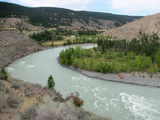 This unusual landscape along the Chilcotin river in British Columbia illustrates the warmest, driest, lower elevations of the Chilcotin Ranges and Fraser Plateau. Here, the slopes are barren and the flatter terrain supports open grassland and shrubs, transitioning to open and then closed coniferous forest as one rises in elevation, visible in the background. The coniferous forest is more common throughout the region but these open areas are found along the major rivers. Photo © David Stanley, CC BY 2.0, Source.