
Home » Regions » North America » Marine West Coast Forest » Puget Lowlands / Georgia Depression
Puget Lowlands / Georgia Depression
Last updated: June 20th, 2022
To check where a specific point lies, you can look it up in our Ecoregion Locator.
↑Map Legend & Subregion List
This list will help you navigate the regions in case you have problems with viewing or clicking the interactive map above.
| Name | † | Color on Map | EPA Code‡ |
| Fraser Lowland | ○ | 2a | |
| Eastern Puget Riverine Lowlands | ○ | 2b | |
| San Juan Islands | ○ | 2c | |
| Olympic Rainshadow | ○ | 2d | |
| Eastern Puget Uplands | ○ | 2e | |
| Central Puget Lowland | ○ | 2f | |
| Southern Puget Prairies | ○ | 2g | |
| Cowlitz/Chehalis Foothills | ○ | 2h | |
| Cowlitz/Newaukum Prairie Floodplains | ○ | 2i |
† Status: ✓ = Complete ○ = Needs Image … = Incomplete ∅ = Stub Only
‡ This code refers to the US EPA's Level 4 ecoregion codes for the continental U.S., see here.
↑Progress
Partially Complete | With Images | Complete w/ Images |
Get involved! You can help our ecoregion articles progress faster. Help us find photos of these regions. Contact us if you have any additions or corrections to any of these articles. You can also donate to support our ongoing work.
↑About the Puget Lowlands / Georgia Depression
The Puget Lowlands / Georgia Depression, referred to in some documents as the Strait of Georgia/Puget Lowland, is an ecoregion located in northwest Washington state and southwest British Columbia, in the low elevations surrounding Puget sound and Georgia strait, which together can be referred to as the Salish Sea. This region includes numerous islands, peninsulas, and bays. It includes the US EPA Ecoregion labeled 2 or 7.1.7, as well as the Canadian ecoprovince 13.1.Geologically, this area is a glacial trough, and most of the landforms are either glacial moraines in the more rugged areas, and glaciomarine deposits in flatter areas. The climate is on the drier side of a maritime west coast climate, tending towards a Mediterranean climate in the driest locations: temperatures are moderate year-round, with weak seasonality relative to the high latitude, but precipitation is more strongly seasonal, with drier summers and wetter winters. The low elevation and rain shadow from the Olympic mountains produces slightly lower rainfall here than in the coastal areas, but moisture is still enough to support lush forest growth. Drought stress is more of a factor in determining vegetation cover here than in most of the rest of the Marine West Coast Forest. Frosts are common in winter, but snowfall and sub-freezing temperatures tend to be ephemeral except at higher elevations.
Soil types are diverse here, including spodosols, which form under coniferous forests, inceptisols, less-developed from mineral soils, and andisols, a less common soil type that originates on volcanic material.
Originally, this region was mostly covered with coniferous forests. Dominant species included douglas-fir (Pseudotsuga menziesii), western hemlock (Tsuga heterophylla), grand fir (Abies grandis), western redcedar (Thuja plicata), as well as some hardwoods including red alder (Alnus rubra) and bigleaf maple (Acer macrophyllum), with understories of salal (Gaultheria shallon), oregon grape (Berberis aquifolium), and moss. A few locally drier sites have oak woodlands, with Oregon white oak (Quercus garryana), pacific dogwood (Cornus nuttallii), and pacific madrone (Arbutus menziesii).
This area is heavily populated, containing most of the population centers of Washington state, including the Seattle metro area, and the much smaller metro area around Olympia, and in British Columbia, the metro area of Vancouver, which is the third-largest metro area in Canada and the largest in Western Canada. Many of the areas that are not urbanized are utilized as cropland. This is the most developed region (indeed, the only heavily-developed region) in the broader Marine West Coast forests region, reflecting that it is the only largely flat part of this region, excepting at the extreme northern end.
Many plant species reach their northern range limits in this region, frequently in the low elevations along the eastern part of Vancouver Island and along the inlets along the Georgia strait where temperatures are most moderate. The moderate climate also makes it easier for introduced species to thrive, which, combined with the widespread presence of humans here, has led this region to also have large numbers of introduced species that have established in the wild.
In the north of this region, it is bordered to the west by the Coastal Western Hemlock-Sitka Spruce Forests, a more mountainous ocean-facing region which tends to be cool, moderate, and have higher rainfall and more consistent moisture year-round. To the northeast this region is bordered by the Pacific and Nass Ranges, a similar mountainous region that is farther inland and thus has more temperature variability and slightly lower rainfall, with glaciers at high elevations. To the southwest this region is bordered by the Coast Range, a coastal mountain range where the climate has greater Mediterranean influence, with drier summers. In the south this region is bordered to the east by the North Cascades; although this region is also vaguely similar in being montainous and moderate in climate, being located both inland and slightly farther south, it is the driest of the directly bordering regions and tends to have the most temperature variability; it also has glaciers at high elevations. All of these borders represent gradual transitions rather than well-defined cutoffs.
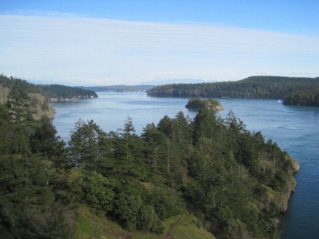 This photo shows typical scenery along one of the less-populated parts of Puget Sound; although parts of this region are flatter, there are many regions like this where the terrain is steep, with cliffs next to the water. Coniferous forest covers the landscape except where it has been cleared. Photo © Chris Ballance, CC BY 2.0, Source.
Plant Lists & In-Region Search
List Native Plants - List All Plants
Warning! This region extends outside the lower 48 US. We have only completed range maps for all plants in the lower 48 US; these lists and searches may thus have omissions for species which only occur in the portion of this region outside the lower 48 US.
↑References
1. Wiken, E., Griffith, G. "North American Terrestrial Ecoregions - Level III", Commission for Environmental Cooperation, (2011) Web.