
Home » Regions » North America » North American Deserts » Cold Deserts » Thompson-Okanagan Plateau
Thompson-Okanagan Plateau
Last updated: August 4th, 2023
Page contents
↑About the Thompson-Okanagan Plateau
The Thompson-Okanagan Plateau, which in some documents is misspelled as the Thompson-Okanogan Plateau, is a slightly lower, flatter region surrounded by mountains, located in southern British Columbia. Although most of this region is only semi-arid, it contains the Okanagan Desert, the warmest, driest part of Canada, the only desert in Canada, and the northernmost reaches of North America's deserts. The western, southern, and northern borders of this ecoregion are drawn less on the basis of geology and more climate, but the eastern borders are geologically-defined.The climate here is a product of the low elevations and rain shadow from mountain ranges, primarily to the west, but to some degree from all sides. The climate ranges from semi-arid to a desert climate; there is significant seasonality of temperature, with warm summers and cold winters. Precipitation is highest in summer; winters tend to be cloudier but with negligible rain and only light snowfall.
The terrain here mostly consists of rolling plateaus alternating with broad river valleys, although there are rugged hills and steep ravines in some of the places where rivers and streams cut through the plateau surface. The plateau is more dissected around the edges of the region and tends to be flatter towards the interior. Much of the surface of this region is covered in glacial moraines, some of which are made of calcareous materials. There are also significant areas of lake sediments, especially at mid-elevations, that formed under glacial lakes that have since drained. Valleys and lower elevations frequently have chernozemic soils or black soils, highly fertile soils high in organic matter, phosporus, and nitrogen, and with a strong potential for holding water.
The combination of soils with a strong seasonality of precipitation, mostly falling during the growing season, tends to make its vegetation cover a bit richer than is typical for regions with such low rainfall. The vegetation tends to range from grassland and scrubland on the driest sites to open coniferous forests on the wettest sites.
Bottomlands here support savanna with open stands of Douglas-fir (Pseudotsuga menziesii) and pinegrass (Calamagrostis rubescens), or scattered ponderosa pine (Pinus ponderosa) and lodgepole pine (Pinus contorta) growing with bluebunch wheatgrass (Pseudoroegneria spicata) and sagebrush (Artesimia sp.). The driest parts of the region feature grasslands of bluebunch wheatgrass, bluegrass (Poa sp.), prairie junegrass (Koeleria macrantha), sagebrush, rabbitbrush, and antelope bitterbrush (Purshia tridentata). The higher elevations in this region, with slightly higher precipitation, support open stands of engelmann spruce (Picea engelmannii), subalpine fir (Abies lasiocarpa), and lodgepole pine.
Land use here is diverse, but not particularly intensive. Bottomlands are used for grazing, forage crops, orchards, residential development, and water-centered recreation, whereas hillier terrain and higher elevation lands are also used for grazing, as well as forestry, hunting, and other recreation. The largest city here is Kelowna, followed by Kamloops, Vernon, and then Penticton; there is some suburban development outside each of these cities. Outside of these there are a number of smaller towns.
This region is bordered to the east, west, and south by mountainous regions with higher elevations and precipitation. It is bordered to the west by the Pacific and Nass Ranges, a cold, humid region with glaciers at the highest elevations; this border is subjective and represents a gradual transition rather than a change in underlying geology. The border to the south is with the North Cascades. To the east, there is a well-defined border with the Northern Rockies, marked by an abrupt change in which the topography immediately becomes more rugged. To the north, this region is bordered by the Chilcotin Ranges and Fraser Plateau, which is only slightly higher in elevation; this border is gradual and represents a subjective cutoff, although it tends to loosely follow the transition from more open vegetation cover characteristic of a semiarid climate, to the richer cover typical of a humid continental climate.
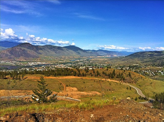 This photo shows the Kamloops Valley, the second-most populous area in the Thompson-Okanagan Plateau. The landscape here shows the typical range of vegetation here, with savanna and grasslands at the lower elevations and open forests at higher elevations. The broad valley in between hillier terrain, and moderate intensity of land use are also both typical of this region. Photo © Kyle Pearce, CC BY 2.0, Source.