
Home » Regions » North America » Mediterranean California » Central California Valley
Central California Valley
Last updated: November 10th, 2023
To check where a specific point lies, you can look it up in our Ecoregion Locator.
↑Map Legend & Subregion List
This list will help you navigate the regions in case you have problems with viewing or clicking the interactive map above.
† Status: ✓ = Complete ○ = Needs Image … = Incomplete ∅ = Stub Only
‡ This code refers to the US EPA's Level 4 ecoregion codes for the continental U.S., see here.
↑Progress
Partially Complete | With Images | Complete w/ Images |
Get involved! You can help our ecoregion articles progress faster. Help us find photos of these regions. Contact us if you have any additions or corrections to any of these articles. You can also donate to support our ongoing work.
↑About the Central California Valley
The Central California Valley is a relatively-flat region extending north-south in California, lying between the coastal mountain ranges to the west and the Sierra Nevada to the east. This region is almost entirely occupied by intensive agriculture, with a number of small-to-medium cities throughout, and has little wild land remaining. It faces severe environmental problems as a result, including soil salinity, groundwater contamination, and air pollution.The climate here is intermediate between a hot-summer Mediterranean climate and a semiarid (steppe) climate, with the southern portions of this region tending more towards semiarid, and the southernmost end approcahing a cold desert climate. Summers are long and dry, and winters are mild and bring moderate rainfall. The climate is drier than the higher-elevation areas to the east and west, but wetter than deserts in low-elevation areas farther east and south. The low coastal mountains produce some rain shadow, but less than in areas of similar elevation surrounded by higher mountains. Precipitation increases northward and at higher elevations. Rainfall increases significantly moving northward, and is over three times as high at the north end than the south, but temperatures are remarkably consistent over the entire length of this region.
Proximity to the ocean moderates temperatures somewhat, but less than in coastal areas; hotter summer temperatures are more common here than near the coast, but temperature variability is much lower than in nearby mountains or inland deserts. Frost is possible here and most of the region experiences at least one light frost in most winters, but not consistently. Heat waves are common in the four hottest months, and often bring temperatures over 100°F. Rare cold waves can bring colder temperatures to 20°F or below. Counterintuitively, these cold waves can hit harder in the south due to the drier climate there leading to less temperature moderation.
The terrain is mostly flat, with some gently rolling hills. There are both perennial and seasonal streams, both of which tend to be low-gradient. Much of the water in this area originates outside this region and enters by means of rivers and streams. The two large rivers, the San Joaquin and Sacramento rivers, are fed by moisture from the higher-elevation Sierra Nevada to the east. Streams originating in the west are more likely to be seasonal.
Original vegetation cover here was mostly grassland with some savannas, and woodlands in riparian areas. Grasslands supported various bunchgrasses and both perennial and annual grasses and some broadleaf herbaceous plants. There were some wetlands. Little of the original cover remains, although there are relatively more of the bottomland woodlands and wetlands intact. This region has a higher-than-normal rate of invasive species and the few wild areas here are disproportionately overrun with invasive plants. The high portion of invasive plants here is a result both of introductions through agriculture, and the near-total lack of preservation of wild ecosystems here.
Prior to European contact, much of this region was inhabited by the Yokuts (a word meaning "people"), who sustained themselves through hunting, fishing, and gathering wild foods; acorns were a staple food. The Yokuts were enslaved by the Spanish and forced to work in agriculture, and their numbers were greatly diminished by diseases introduced by the Spanish and later the British, and only a few thousand survive today.
This area is heavily utilized for agriculture, which relies on extensive irrigation. Only about one-fourth of the cropland is not irrigated. Major crops include rice, almonds, apricots, olives, grapes, cotton, various citrus, and assorted vegetables. There is a small amount of dairy farming. Although the agriculture here is economically diversified in the sense that this region produces many different types of crops, most of it exists in the form of large-scale industrial monocultures, and there is almost no traditional diversified farming with multiple crops planted together in a small area and/or wild areas left intact on each farm. Besides agriculture there is a small amount of oil and gas extraction. Although this region is less urbanized than the coastal areas in California, it still has some small to medium cities. The larger cities are Fresno and Sacramento, followed by Bakersfield, Stockton, Modesto, and the smaller cities of Redding and Chico.
This area faces serious and widespread environmental problems. Nearly all the upland habitat and a large portion of the bottomland habitat has been lost due mostly to agriculture, and to a lesser degree, urban development. There is a major problem with increased soil salinity caused by evaporation of irrigation water, and the water has also become contaminated by heavy agricultural chemical use. This region also tends to have very poor air quality, especially in the south where there is less rainfall; parts of this region are as bad as the Los Angeles metro area and have among the worst air quality anywhere in North America. Air quality tends to be worse in fall and winter, when a temperature inversion traps air in the valley.
This region is entirely surrounded by the California Coastal Sage, Chaparral, and Oak Woodlands. Although the rivers here drain into the ocean through the Bay Area, they flow through a narrow waterway surrounded by more rugged, higher-elevation areas that keeps this region more-or-less completely separated from the ocean.
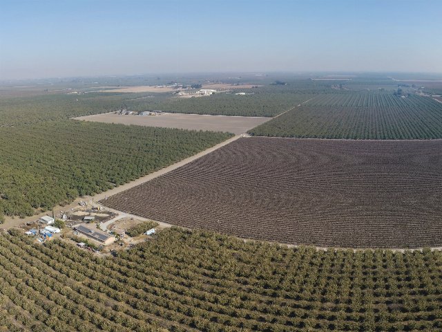 This aerial view of Chowchilla, CA shows pistachios in the foreground. California's Central Valley is almost entirely filled with intensive monocultures like shown here, with little wild land remaining. The pictured farm, Forever Grateful Ranch, is a leader in soil conservation practices, using compost instead of chemical fertilizers, and also using cover crops. Unfortunately, the most commonly-used cover crop with pistachios is soft brome (Bromus hordeaceus), itself an invasive species. These dilemmas are typical of the multifaceted environmental impacts of intensive agriculture and illustrate the need for a paradigm shift. Photo © US Department of Agriculture, Public Domain, Source.
Plant Lists & In-Region Search
↑References
1. Wiken, E., Griffith, G. "North American Terrestrial Ecoregions - Level III", Commission for Environmental Cooperation, (2011) Web.