
Home » Regions » North America » Northwestern Forested Mountains » Western Cordillera » Sierra Nevada
Sierra Nevada
Last updated: September 19th, 2023
Page contents
To check where a specific point lies, you can look it up in our Ecoregion Locator.
↑Map Legend & Subregion List
This list will help you navigate the regions in case you have problems with viewing or clicking the interactive map above.
† Status: ✓ = Complete ○ = Needs Image … = Incomplete ∅ = Stub Only
‡ This code refers to the US EPA's Level 4 ecoregion codes for the continental U.S., see here.
↑Progress
Partially Complete | With Images | Complete w/ Images |
Get involved! You can help our ecoregion articles progress faster. Help us find photos of these regions. Contact us if you have any additions or corrections to any of these articles. You can also donate to support our ongoing work.
↑About the Sierra Nevada
The Sierra Nevada, which is properly singular but often casually referred to in the plural as the Sierra Nevadas, is a mountain range located primarily in California, extending barely into Nevada, near the angle point of the CA-NV border, which is near Lake Tahoe.The climate here is usually described as Mediterranean, but due to the inland location and higher elevation, it is more variable and severe, and has higher total precipitation, relative to lower-elevation areas closer to the coast. Precipitation is lower at lower elevations, but also decreases on the eastern slopes due to rain shadow. Annual rainfall varies from about 6 in (150mm) at low elevations in the east, to nearly 100 in (2500mm) near the highest peaks. Precipitation is strongly seasonal throughout the whole region, with wet winters and dry summers. On most of the western slopes, total rainfall is high, but summer still brings weeks to months with no rain. Seasonality of precipitation becomes more pronounced to the south and west; although eastern slopes have lower total rainfall, they have more continental influence, with relatively drier winters and slightly wetter summers as compared to the rest of the region. This region is far enough south that it lacks persistent snow cover. The highest peaks remain snow-capped in some years, but in warmer years all the snow melts in summer.
The region is home to many high-gradient perennial streams and rivers. Snowmelt during the warm season stabilizes the flow of these waterways by providing a water source during the dry season. There are numerous natural alpine lakes of varying sizes.
Geologically, this region consists of a deeply dissected block fault. The rocks here formed deep underground over a hundred million years ago, but the uplift only began within the past 5 million years. The rocks were then eroded by glaciers, and have continued to be eroded by water following the glaciers' retreat. The eastern slopes tend to be very sharp and steep, whereas the western slopes into California's central valley are more gradual. The height of the mountains tends to increase from north to south, which leads to some consistency in climate and vegetation of the higher elevations over the length of this region, but also to greater variation in vegetation cover in the south of the region.
This region is mostly covered in coniferous forests, but has an extraordinary diversity of species and cover types. The lowest elevations in the west have some chapparal, with ponderosa pine (Pinus ponderosa) being the first tree to appear when moving up the slopes. On the eastern slope, lodgepole pine (Pinus contorta) is the first such tree to appear. As elevations and rainfall increase, forests become richer and increasingly diverse, and include ponderosa pine, sugar pine (Pinus lambertiana), douglas-fir (Pseudotsuga menziesii), and white fir (Abies concolor). There are some areas of giant sequoia (Sequoiadendron giganteum), which are the most massive trees on the planet. Slightly higher elevations support forests of mostly white fir and California red fir (Abies magnifica). The subalpine zone has a mix of lodgepole pine, Jeffrey pine (Pinus jeffreyi), western white pine (Pinus monticola), limber pine (Pinus flexilis), which gives way to aspen and spruce closer to the tree line. The highest elevations open to alpine meadows and rocky summits.
This ecoregion has an unusually large number of endemic species, most sources reporting over 400, although the exact number varies based on differences in taxonomy. Most of these species are rare and endangered. Although many of these species occur in protected land, those that occur towards the westernmost border of this region are more vulnerable due to encroachment by agriculture and urbanization.
Land use here includes recreation and tourism, forestry, ranching and grazing, and some mining. This region is more populous than mountainous regions farther north, reflecting the milder climate here. The largest settlement here is South Lake Tahoe, followed by Truckee and Grass Valley, with other larger towns including Mammoth Lakes and the unincorporated community of Alta Sierra. All of these are in California; the largest settlement in Nevada is the unincorporated community of Incline Village. The highest elevations mostly consist of public, protected lands, including national forests, national monuments, and national parks. There has also been extensive damming of various rivers here, in some cases creating new reservoirs and in other cases, expanding or regulating the height of naturally-occurring lakes. These reservoirs are used to supply water to areas outside this region, mostly regions to the west in California, where they are used both for agricultural irrigation and municipal water supply.
This region is bordered to the west by the California Coastal Sage, Chaparral, and Oak Woodlands, an area of lower elevation and rainfall, with a milder, but drier Mediterranean climate. To the north, this region is bordered by the Eastern Cascades Slopes and Foothills. To the east, this region is bordered by lower, flatter desert regions, the Central Basin and Range in the north of this region, and the Mojave Basin and Range south of that, also wrapping around the southernmost end of this region. The far southern end of this region also shares a border to the south with the Southern California Mountains, a mountain range extending closer to the coast of Southern California, with a more ocean-moderated Mediterranean climate.
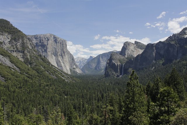 Yosemite National Park is one of the most iconic landscapes within the Sierra Nevada ecoregion. This scenery is typical of the higher elevations in this region; the valley here is just below 4,000ft (1,220m) and is covered in coniferous forest, with the higher elevations reaching into the subalpine zone. Most of the region is not quite as rugged as pictured here. Photo © Edward Stojakovic, CC BY 2.0, Source.