
Home » Regions » North America » Northwestern Forested Mountains » Western Cordillera » North Cascades
North Cascades
Last updated: June 21st, 2022
To check where a specific point lies, you can look it up in our Ecoregion Locator.
↑Map Legend & Subregion List
This list will help you navigate the regions in case you have problems with viewing or clicking the interactive map above.
| Name | † | Color on Map | EPA Code‡ |
| North Cascades Lowland Forests | ○ | 77a | |
| North Cascades Highland Forests | ○ | 77b | |
| North Cascades Subalpine/Alpine | ○ | 77c | |
| Pasayten/Sawtooth Highlands | ○ | 77d | |
| Okanogan Pine/Fir Hills | ○ | 77e | |
| Chelan Tephra Hills | ○ | 77f | |
| Wenatchee/Chelan Highlands | ○ | 77g | |
| Chiwaukum Hills and Lowlands | ○ | 77h | |
| High Olympics | ○ | 77i |
† Status: ✓ = Complete ○ = Needs Image … = Incomplete ∅ = Stub Only
‡ This code refers to the US EPA's Level 4 ecoregion codes for the continental U.S., see here.
↑Progress
Partially Complete | With Images | Complete w/ Images |
Get involved! You can help our ecoregion articles progress faster. Help us find photos of these regions. Contact us if you have any additions or corrections to any of these articles. You can also donate to support our ongoing work.
↑About the North Cascades
The North Cascades are a region encompassing the northern end of the Cascade Range, located mostly in north-central to northwest Washington State, extending slightly into southern British Columbia, and also including a small disjunct piece of the high Olympic Mountains west of the Puget Lowlands.This region consists of high, rugged mountains shaped by glaciation, with active glaciers at the highest elevations. This region contains the greatest concentration of active glaciers in the lower 48 states. The underlying rock consists of a greater portion of sedimentary and metamorphic rock, contrasting with the largely volcanic rocks farther south. However, there are still some volcanic areas, including the active volcanoes Mount Baker and Glacier Peak, and a number of extinct volcanoes. There are numerous high-gradient perennial streams, as well as many glacial lakes. Because of the combination of recent glaciation and high rainfall, there are a mix of valley shapes, with both U-shaped valleys formed by glaciers and V-shaped valleys formed by water.
The climate here varies considerably, tending to transition from a maritime west coast climate in the west of the region, to a dry continental climate in the east. Precipitation is seasonal; summers are warm and dry, and winters are cold and wet. Temperatures as well as the duration of the frost-free period vary wildly by elevation, with a frost-free period ranging from 200 days to as short as 40. Similarly, precipitation is wildly variable, from about 12 in (300mm) annually at lower elevations in the east, to an insane 236 in (6,000mm) at high elevations in the west.
The vegetation cover here varies by elevation. Lower-elevations in the west support western hemlock (Tsuga heterophylla), western redcedar (Thuja plicata), and douglas-fir (Pseudotsuga menziesii). Higher elevations support subalpine forests of engelmann spruce (Picea engelmannii), subalpine fir (Abies lasiocarpa), and lodgepole pine (Pinus contorta). At low elevations in the east, forests are drier and more open, dominated by ponderosa pine (Pinus ponderosa) and Douglas-fir; the driest sites feature open grass parklands with pines becoming increasingly scattered.
This area is mostly sparsely populated, with settlements concentrated in a few broad, flat valleys along rivers that cut through the region. The largest such settlements are Leavenworth, WA, followed by Keremeos, BC, Concrete, WA, and Hedley, BC. Land uses here include recreation and tourism, forestry, woodland grazing, and water supply for adjacent, drier regions. Although it represents only a small portion of land area in this region, the flat land in some of the more accessible valleys is intensively farmed as cropland. Damming has created some artificial reservoirs, and has also increased the size and depth of Lake Chelan, the largest natural lake in this region. There is significant public land, including national parks, national forest, and state or provincial parks.
Most of this region is bordered to the west by the Puget Lowlands / Georgia Depression, a lower-elevation, drier, and more heavily deveolped region which contains most of the population of the Pacific Northwest, and also partly surrounds the discontigous western part of this region. This western portion is also bordered to the west by the Coast Range, a coastal mountainous region with a heavily ocean-moderated climate. At the south end of this region, there is a small border with the Cascades, the more southerly portion of the same mountain range, which is both warmer in climate and more volcanically active. To the east, this region is bordered by the Columbia Plateau in the south of the region, and in the north, it is bordered to the east and northeast by the Thompson-Okanogan Plateau. Both of these are arid, relatively flat regions that together, make up the two most northerly of the Cold Deserts of North America. In the north of this region, there is a small border to the northwest with the Pacific and Nass Ranges, a colder and more consistently-humid mountainous region.
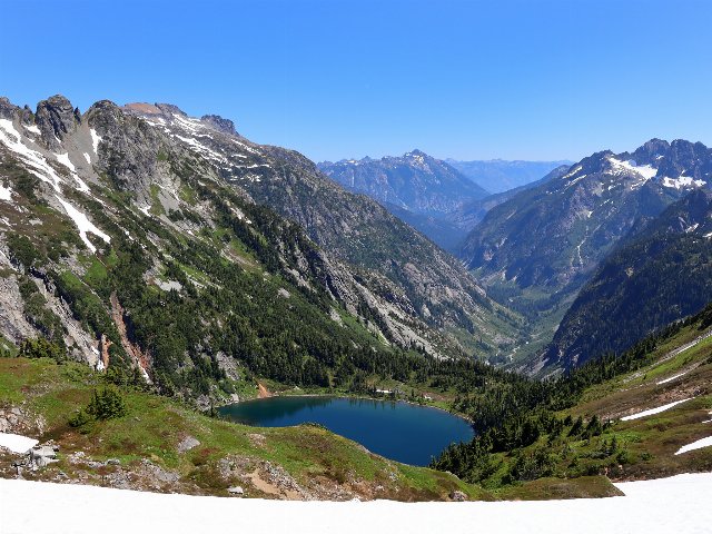 This photo of Doubtful Lake and Cascade Pass taken in summer shows many characteristics of the North Cascades, with steep, rugged topography, persistent snow at the higher elevations, coniferous forest below the tree line and meadows below, a glacial lake, and a U-shaped valley formed by glaciers. Photo © Jeff Hollett, Public Domain, Source.
Plant Lists & In-Region Search
List Native Plants - List All Plants
Warning! This region extends outside the lower 48 US. We have only completed range maps for all plants in the lower 48 US; these lists and searches may thus have omissions for species which only occur in the portion of this region outside the lower 48 US.