Home » Regions » North America » Northern Forests » Mixed Wood Shield » Northern Lakes and Forests » Onaway Moraines
Onaway Moraines
Last updated: August 17th, 2020
Page contents
↑About the Onaway Moraines
The Onaway Moraines are a region in the northeast of the lower peninsula of Michigan, consisting of several discontinuous pieces, also encompassing several islands, including Bear Island, the largest island in Lake Michigan. This region is mostly covered in ground moraines.This region has highly variable in its land forms. The ground moraine varies from rolling hills to quite steep in places, and there are also drumlins and outwash deposits. Glacial drift is thick, up to 500 feet deep, in the south, but it becomes shallower in the north. Along the lake, the carbonate bedrock is near the surface, and there are some areas of karst topography. Soils throughout the region are also variable, from droughty, excessively-well-drained soils to poorly-drained in other places. There are some areas with high concentrations of small lakes and kettle ponds.
The climate in this region is moderated by the presence of Lakes Michigan and Huron, but it is also influenced by cold air draining off the high-elevation Mio Plateau to the south. Much of this region also experiences heavy lake-effect snow.
Originally this region was mostly forested, with diverse forest types on the different sites. Drier soils on glacial outwash supported northern red oak (Quercus rubra), red pine (Pinus resinosa), eastern white pine (Pinus strobus), and pitch pine (Pinus rigida). Ground moraine and drumlins supported Northern Hardwood forests with American beech (Fagus grandifolia) and sugar maple (Acer saccharum). Wetlands and swamps featured northern white-cedar (Thuja occidentalis), tamarack (Larix laricina), black spruce (Picea mariana), and black ash (Fraxinus nigra). Sites subject to cold air drainage supported pockets of boreal forests dominated by northern white-cedar, balsam fir (Abies balsamea), and white spruce (Picea glauca) and black spruce.
Areas with rocky soils that originally supported northern hardwood forest have been mostly cleared, and are now used for agriculture, producing potatoes and row crops, with significant pastureland as well. However, much of the land is presently forested. This area is sparsely populated, with the three largest towns being Atlanta, Hillman, and Posen, all under 1,000 people. There is significant public land, including the Atlanta State Forest Area.
The eastern portion of this region is bordered to the northeast by the Cheboygan Lake Plain, a flatter region with more exposed carbonate bedrock, and to the southwest by the Vanderbilt Moraines, a region with steeper terminal moraines, contrasting with the rolling ground moraines of this region. The far southern end of this region directly borders the higher elevation, colder Mio Plateau to the southwest and the lower, milder Tawas Lake Plain to the southeast. The separate northern parts of this region are surrounded by the Cheboygan Lake Plain except where they border Lake Michigan directly.
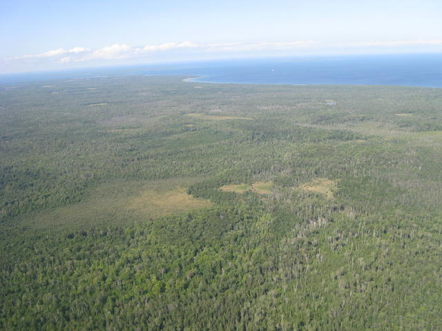
 Beaver Island, pictured here, is the largest island in Lake Michigan, and, like the rest of the Onaway moraines, is formed of ground moraine, with varied land forms and a diversity of vegetation cover types, visible in the somewhat patchy distribution of forests in this picture. Photo © Mike Maehr, CC BY-SA 2.0, Source.
Plant Lists & In-Region Search
We do not yet have data to generate plant lists for a region as fine-tuned as this one. However you can move up to the broader Northern Lakes and Forests and generate lists for that region: native plants or all plants. Or search that region's plants here:
↑References
1. Omernik, J.M., Bryce, S.A. "Michigan: Level III and IV Ecoregion Descriptions / Mapping Issues", US EPA (2007) Web.


