
Home » Regions » North America » Northern Forests » Mixed Wood Shield » Northern Lakes and Forests » Vanderbilt Moraines
Vanderbilt Moraines
Last updated: July 28th, 2020
↑About the Vanderbilt Moraines
The Vanderbilt Moraines are a relatively long and narrow, irregularly-shaped region in the north of the lower peninsula of Michigan separating the flat, high-elevation Mio Plateau to the south from the lake plains to the north, northwest, and northeast.This region was formed by multiple periods of advancing and retreating of ice sheets in the great lakes basin, and consists of terminal moraines that form a plateau escarpment with the Mio Plateau to the south. The topography is heavily-dissected and some of the steepest anywhere in Michigan's lower peninsula, with steep slopes and narrow valleys leading into wider outwash channels and broad, flat plains at the lowest elevations. Soils are sandy and mostly well-drained, very deep in most places, leading there to be few lakes. However, in the bottomlands, the water table is higher and there are more streams and rivers, and occasional small kettle lakes. Streams flow through historic outwash channels, so the streams are small relative to the size of the valleys they inhabit. The region has a humid continental climate, with complex interactions between the lake-moderated air at lower elevations and the cold air coming off the higher inland plateau, which tends to drain through the narrow valleys to accumulate in the lower areas, many of which are mostly-surrounded by areas of higher elevation. Temperature variations can thus be more extreme than areas to the north, with high risk of early and late frosts.
This area was originally almost entirely forested. Most of the steeper moraines were covered with northern hardwood forests, with American beech (Fagus grandifolia), sugar maple (Acer saccharum), yellow birch (Betula alleghaniensis), and eastern hemlock (Tsuga canadensis) as dominants. Some of the narrower outwash channels with poorly-drained soils, supported swamps variously dominated by conifers or mixes of conifers and hardwoods, with northern white-cedar (Thuja occidentalis) a common species. The broader outwash channels, with excessively well-drained soil, supported jack pine (Pinus banksiana) and red pine (Pinus resinosa); large fires were common here and maintained this plant community, sometimes encroaching on the northern hardwood forests.
Due to its steep topography, this region has less intensive land use patterns and much greater forest cover than the surroundings. It is also sparsely populated; the largest town is Vanderbilt, followed by Wolverine; both have only a few hundred people. A large portion of this region is state-owned and managed both for timber and wildlife. State lands include the Gaylord State Forest Area, and land managers include Mackinaw State Forest, Huron National Forest, Petoskey State Park, and the Oden State Fish Hatchery.
This region is bordered to the south by the high-elevation, colder Mio Plateau. In the east, it is bordered to the northeast by the Onaway Moraines, an area of ground-moraines that has more irregular, rolling topography that averages less rugged. In the north, this region opens up directly onto the Cheboygan Lake Plain, a low, flat area with more exposed carbonate bedrock. In the west, it is bordered to the northwest by the Manistee-Leelanau Shore, an area with sandy soils, a strongly lake-moderated climate, and an abundance of orchards.
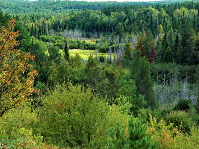 This view taken from Inspiration Point along the Pigeon River, shows the steep topography and forested landscape typcial of the Vanderbilt Moraines. The valley of the Pigeon river is one of the narrower outwash channels with more poorly-drained soils, and thus more wetlands. Photo © Erik Przekop, CC BY-SA 2.0, Source.
Plant Lists & In-Region Search
We do not yet have data to generate plant lists for a region as fine-tuned as this one. However you can move up to the broader Northern Lakes and Forests and generate lists for that region: native plants or all plants. Or search that region's plants here:
↑References
1. Omernik, J.M., Bryce, S.A. "Michigan: Level III and IV Ecoregion Descriptions / Mapping Issues", US EPA (2007) Web.
2. Albert, Dennis A. "Regional landscape ecosystems of Michigan, Minnesota, and Wisconsin: a working map and classification.", General Technical Report NC-178, U.S. Department of Agriculture, Forest Service, North Central Forest Experiment Station, St. Paul, MN (1995) Web.