
Home » Regions » North America » Eastern Temperate Forests » Mixed Wood Plains » North Central Hardwood Forests » Manistee-Leelanau Shore
Manistee-Leelanau Shore
Last updated: July 22nd, 2020
↑About the Manistee-Leelanau Shore
The Manistee-Leelanau Shore is a region in the northwestern portion of Michigan's lower peninsula, along the shores of Lake Michigan. It includes the Manitou islands.This region has highly variable topography, ranging from locally very flat to rugged, hilly terrain, including sand dunes and steep terminal moraines. Soils are sandy, with considerable variation in both depth and texture of soils. This region has a humid continental climate that is cold but lake-moderated. The coastline is more irregular than the the surroundings. There are numerous lakes just inland of the main lakeshore, and an area of bays and peninsulas around grand traverse bay.
Historically, this region was mostly forested. The humid climate led to dominance of northern hardwood forests, with American beech (Fagus grandifolia) and sugar maple (Acer saccharum) as dominant trees, even on well-drained sands. The cooler climate here also led to a greater portion of evergreen conifers than areas to the south, including eastern hemlock (Tsuga canadensis) and eastern white pine (Pinus strobus). In the south of the region, these forests also contained significant amounts of black oak (Quercus velutina). In the east, drumlins also had significant American basswood (Tilia americana), white ash (Fraxinus americana), and American hophornbeam (Ostrya virginiana). Sand dunes along the lake supported white pine along with red pine (Pinus resinosa) and jack pine (Pinus banksiana). Poorly-drained sites supported forested swamps with American elm (Ulmus americana), ash, tamarack (Larix laricina), and northern white-cedar (Thuja occidentalis), with white-cedar particularly dominating the bottomlands between the drumlins in the east; there were also large areas of open marsh surrounding the coastal lakes just inland of the shoreline.
Current land use is mixed. Along the lake, there is siginficant production of cherries, apples, and grapes. Farther inland, there is production of corn, other grain, and hay. There is also significant pastureland, with a greater portion of pastureland found on coarser sands. The driest soils and steeper slopes of all soil types are mostly forested. Excessively well-drained sands currently support beech-sugar maple forest as well as red and white pine. Logged pine forests have not regenerated well, and in many places were replaced by quaking aspen (Populus tremuloides), red maple (Acer rubrum), and paper birch (Betula papyrifera). Steep sites on more fine-textured soils support beech, maple, aspen, hemlock, and red pine.
This area is also more populated than most parts of the northern lower peninsula; Traverse City is the largest city, and there are numerous smaller towns. A 35 mile (56km) long stretch of shoreline here is protected as part of Sleeping Bear Dunes National Lakeshore, and includes the Manitou islands. There is significant recreation here, and some residential development near the dune area as well.
This region is bordered to the south by the Michigan Lake Plain, which has a warmer climate and a greater portion of clayey and poorly-drained soils. In the south, there is a small border to the southeast with the Newaygo Barrens, a fire-prone inland area. Inland, this region partly surrounds the Platte River Outwash, and farther east, over most of this region it is bordered to the southeast by the Vanderbilt Moraines. At the far northeast there is also a small border with the Cheboygan Lake Plain.
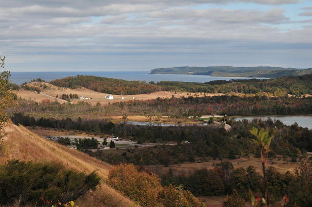 This photo shows the landscape at Sleeping Bear Dunes National Lakeshore; this region features irregular topography, steep in places and flat in others, with sandy soil and an irregular coastline with numerous bays and peninsulas. Photo © abarndweller (Flickr), CC BY 2.0, Source.
Plant Lists & In-Region Search
We do not yet have data to generate plant lists for a region as fine-tuned as this one. However you can move up to the broader North Central Hardwood Forests and generate lists for that region: native plants or all plants. Or search that region's plants here:
↑References
1. Omernik, J.M., Bryce, S.A. "Michigan: Level III and IV Ecoregion Descriptions / Mapping Issues", US EPA (2007) Web.
2. Albert, Dennis A. "Regional landscape ecosystems of Michigan, Minnesota, and Wisconsin: a working map and classification.", General Technical Report NC-178, U.S. Department of Agriculture, Forest Service, North Central Forest Experiment Station, St. Paul, MN (1995) Web.