
Home » Regions » North America » Northern Forests » Atlantic Highlands » Northeastern Highlands » Worcester/Monadnock Plateau
Worcester/Monadnock Plateau
Last updated: November 12th, 2021
Page contents
↑About the Worcester/Monadnock Plateau
The Worcester/Monadnock Plateau is a somewhat irregularly-shaped region extending from north-central Massachusetts into southern New Hampshire. This region marks the beginning of the colder and more mountainous Northeastern Highlands region.The terrain here consists of a rolling plateau with scattered monadnocks, isolated hills or small mountains rising conspicuously above their surroundings. There are numerous ponds and lakes, and some artificial reservoirs as well. The area is underlain by mostly metamorphic rock with some igneous rock, and is covered in much of the region by glacial till. The bedrock, which is exposed at many of the highest elevations, is diverse, and includes such rocks as schist, phyllite, tonalite, quartz diorite, gneiss, granite, biotite granofels, metapelite, and metasandstone. Glacial till tends to be sandy or gravely, with some areas of finer silt. Soils here are fairly diverse in texture and depth, but tend to be acidic, mostly spodosols on richer, more-developed sites, and inceptisols on sites where the soil was more recently derived from weathered rock.
The region has a humid continental climate, significantly colder than coastal areas. The growing season ranges from 115-145 days. Precipitation is high overall, but varies considerably by altitude. Winters have much lower total precipitation due to consistently colder temperatures, but there can still be significant snowfall from late November well into March.
This region was originally almost entirely forested, with typical forest types transitional between northern hardwoods to the north and at higher elevations, and some influence of Appalachian oak forest on warmer, drier sites, at lower elevations, and farther south, but overall this region tended more towards northern hardwoods. Diversity of forest types is high in this region owing in part to different microclimates created around the monadnocks, where temperature and moisture levels change as a function of elevation and topography.
Dry sites featured red-oak-white-pine forest or oak-hemlock-white-pine forest, mostly with a mix of white oak (Quercus alba) and northern red oak (Quercus rubra), and chestnut oak (Quercus montana), eastern hemlock (Tsuga canadensis), and eastern white pine (Pinus strobus), along with smaller amounts of sweet birch (Betula lenta) and red maple (Acer rubrum). The warmest sites featured Appalachian oak forest, with northern red oak, white oak, black oak (Quercus velutina), pignut hickory (Carya glabra), shagbark hickory (Carya ovata), and white pine. Transitional forests featured northern red oak, sugar maple (Acer saccharum), American beech (Fagus grandifolia), sweet birch, and some white pine and hemlock. Towards the cooler end of this region, forests featured hemlock, sugar maple, white ash (Fraxinus americana), yellow birch (Betula alleghaniensis), black cherry (Prunus serotina), paper birch (Betula papyrifera), and aspen, often also with white pine. Swamps and poorly-drained sites featured red maple, green ash (Fraxinus pennsylvanica), yellow birch, and hemlock, and on the most acidic, wettest sites, bogs with black spruce (Picea mariana) and tamarack (Larix laricina). Floodplains of small rivers featured red maple, silver maple (Acer saccharinum), sugar maple, black cherry, and American elm (Ulmus americana).
This area is still mostly forested, and is sparsely populated, utilized somewhat for tourism and recreation. There are small amounts of agriculture, mostly pastureland and hay production, and some forestry, but agriculture here has declined significantly. Some smaller state forests and parks are located here, but they make up an insignificant portion of the total forest. The very small cities of Keene, NH and Gardner, MA are the only settlements of any significant size.
The borders of this region mostly represent gradual transitions corresponding to changes in soil type and forest composition associated with changes in elevation and temperature. To the south lies the geologically-similar but slightly lower and warmer Lower Worcester Plateau/Eastern Connecticut Upland. To the east, the Gulf of Maine Coastal Plain is lower, flatter, and much more densely populated. To the southwest there is a small border with the lower-lying, more agricultural Connecticut Valley. In much of this region, the border to the north is with the Sunapee Uplands, although in the northwest there is a small border with the Vermont Piedmont, and in the northeast, a larger border with the Sebago-Ossipee Hills and Plains.
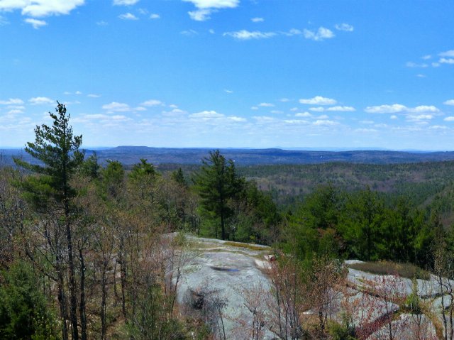 This view, looking west from South Mountain in New Hampshire, shows the diverse scenery typical of the Worcester/Monadnock Plateau, a mostly-forested area in which isolated hills or small mountains stand out from their flatter surroundings. This is a crop of a photo © ihamr (Flickr), CC BY 2.0, Source.
Plant Lists & In-Region Search
We do not yet have data to generate plant lists for a region as fine-tuned as this one. However you can move up to the broader Northeastern Highlands and generate lists for that region: native plants or all plants. Or search that region's plants here:
↑References
1. Griffith, G.E., Omernik, J.M., Bryce, S.A., Royte, J., Hoar, W.D., Homer, J.W., Keirstead, D., Metzler, K.J., and Hellyer, G. "Ecoregions of New England (Poster)", U.S. Geological Survey (2009) Web.