
Home » Regions » North America » Eastern Temperate Forests » Mixed Wood Plains » Northeastern Coastal Zone » Narragansett/Bristol Lowland
Narragansett/Bristol Lowland
Last updated: August 3rd, 2020
Page contents
↑About the Narragansett/Bristol Lowland
The Narragansett/Bristol Lowland is a region in eastern Rhode Island and the portion of Massachusetts east of Rhode Island, extending east not quite the whole way to Cape Cod. It includes the Narragansett Basin and the Narragansett Bay, which is the largest estuary in New England, and the achipelago in the bay, as well as extending farther inland east and northeast from the bay.This is a lowland region, underlain by sedimentary rocks, contrasting with the metamorphic and igneous rocks of neighboring regions to the west and north. The topography ranges from completely flat to gently rolling, irregular plains. The coastline is an irregular mosaic of land and water: there are numerous bays, islands, and peninsulas, and inland from this, numerous wetlands, ponds, and lakes.
The climate here is intermediate between a humid continental and humid subtropical climate. The climate is moderated by its proximity to the ocean as well as the extensive water in the region and the low elevation. Precipitation is high and roughly equally-distributed year-round. The region is far enough north that it is rarely hit by hurricanes, but more frequently by nor'easters, winter storms forming in the north Atlantic ocean. The frost-free growing season of 160-200 days is some of the longest in New England.
This area has some of the greatest diversity of forest types anywhere in New England, and has many plant communities with a more southerly character; many species are common here that become uncommon and/or reach their range limits north of here. The most widespread forest cover is Appalachian oak-pine forest, with northern red oak (Quercus rubra), white oak (Quercus alba), scarlet oak (Quercus coccinea), black oak (Quercus velutina), post oak (Quercus stellata), and chestnut oak (Quercus montana), as well as eastern white pine (Pinus strobus), red maple (Acer rubrum), various hickories, and some other hardwoods. Areas closer to the ocean feature maritime oak-holly woodlands, including scarlet oak, black oak, American holly (Ilex opaca), sassafras (Sassafras albidum), black cherry (Prunus serotina), red maple, some pitch pine (Pinus rigida) and eastern redcedar (Juniperus virginiana), and often a dense layer of shrubs and vines. Floodplains of small rivers feature bottomland forests mostly of pin oak (Quercus palustris) and green ash (Fraxinus pennsylvanica), with some swamp white oak (Quercus bicolor), American sycamore (Platanus occidentalis), red maple, and American elm (Ulmus americana). Swamps have dominant cover of red maple and atlantic white cedar (Chamaecyparis thyoides), along with a shrub layer of alder, highbush blueberry (Vaccinium corymbosum), buttonbush, and winterberry (Ilex verticillata). Bogs feature mostly shrubby growth of leatherleaf (Chamaedaphne calyculata), highbush blueberry, rhododendron, and bog laurel (Kalmia polifolia). Beach and sand dune communities feature American beachgrass (Ammophila breviligulata), beach pea (Lathyrus japonicus), and seaside goldenrod (Solidago sempervirens), and saltmarshes feature saltmeadow cordgrass (Spartina patens), smooth cordgrass (Spartina alterniflora), spike-grass, and saltmarsh rush.
This area was historically farmed much more than today, but as with most of New England, the farming has been largely abandoned in recent years. Although nearly all the forests here were logged, a small tract of old growth Beech forest can be found at Oakland Forest preserve on Aquidneck Island.
Currently this region is a mix of urban and residential development and forest, with only small areas of other uses. This region is more heavily populated than regions to the west and north, although not as urbanized as the area around Boston; it contains the Providence, RI metro area as well as the smaller cities of Brockton, Taunton, and Fall River, MA. There is a small amount of agriculture, mostly cranberry bogs and a small amount of pastureland and hay production. The coastal area also is an important tourist destination, and there are also commercial fisheries along the coast.
Along the coast line, this region is bordered to the west by the Long Island Sound Coastal Lowland, a region with fewer bays and inlets and where the coastal zone is narrower. To the east, the region borders the Cape Cod section of the Cape Cod/Long Island region, in a gradual transition to sandy soils and vegetation cover that is more dominated by pine. Inland, to the north and west, this region has a clear, geologically-defined border with the much rockier Southern New England Coastal Plains and Hills. To the northeast, it borders the Gulf of Maine Coastal Lowland, a similar region with a distinct geology and colder climate.
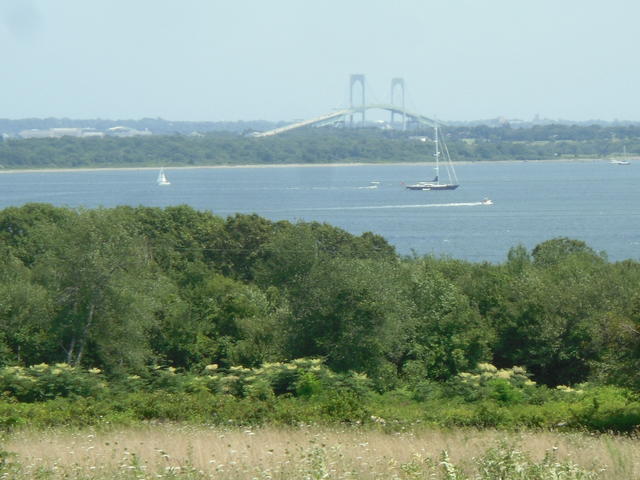 This photo, taken from state route 1A in Rhode Island, shows a typical landscape of the Narragansett Bay area, with a mosaic of water and land, and both wild and developed areas. The proximity to the water moderates the climate in this low-lying region. Photo © Doug Kerr, CC BY-SA 2.0, Source.
Plant Lists & In-Region Search
We do not yet have data to generate plant lists for a region as fine-tuned as this one. However you can move up to the broader Northeastern Coastal Zone and generate lists for that region: native plants or all plants. Or search that region's plants here:
↑References
1. Griffith, G.E., Omernik, J.M., Bryce, S.A., Royte, J., Hoar, W.D., Homer, J.W., Keirstead, D., Metzler, K.J., and Hellyer, G. "Ecoregions of New England (Poster)", U.S. Geological Survey (2009) Web.