
Home » Regions » North America » North American Deserts » Warm Deserts » Chihuahuan Deserts
Chihuahuan Deserts
Last updated: October 23rd, 2023
To check where a specific point lies, you can look it up in our Ecoregion Locator.
↑Map Legend & Subregion List
This list will help you navigate the regions in case you have problems with viewing or clicking the interactive map above.
| Name | † | Color on Map | EPA Code‡ |
| Chihuahuan Basins and Playas | ○ | 24a | |
| Chihuahuan Desert Grasslands | ○ | 24b | |
| Low Mountains and Bajadas | ○ | 24c | |
| Chihuahuan Montane Woodlands | ○ | 24d | |
| Stockton Plateau | ○ | 24e | |
| Rio Grande Floodplain | ○ | 24f | |
| Gypsiferous Dunes | ○ | 24g | |
| Lava Malpais | ○ | 24h |
† Status: ✓ = Complete ○ = Needs Image … = Incomplete ∅ = Stub Only
‡ This code refers to the US EPA's Level 4 ecoregion codes for the continental U.S., see here.
↑Progress
Partially Complete | With Images | Complete w/ Images |
Get involved! You can help our ecoregion articles progress faster. Help us find photos of these regions. Contact us if you have any additions or corrections to any of these articles. You can also donate to support our ongoing work.
↑About the Chihuahuan Deserts
The Chihuahuan Deserts, Spanish desierto chihuahuense, is a large desert region extending through a small portion of West Texas, much of southern New Mexico, a small part of eastern Arizona, and much of north-Central Mexico, including the northeastern portions of Chihuahua, all but northeastern Coahuila, northeastern Durango, northeastern Zacatecas, western Nuevo León, and northwest and central San Luis Potosí. By far the largest portion of this region is in Mexico. This is both the easternmost and southernmost desert region in North America, and is also has some of the largest unbroken areas of desert on the continent. Moving south, this is the last region of desert in the Americas before one reaches the deserts in western South America.The climate here ranges from a subtropical desert to subtropical steppe or semiarid climate at higher elevations. Precpitation is seasonal, following the pattern of the North American Monsoon, with a summer rainy season. In most of the region, the season is pronounced and arrives late, with over half the rainfall arriving between July and September. In the southwest, near Torreón, however, precipitation peaks much earlier, in June, and the seasonality is less pronounced but still significant. The cause for this region's arid climate is rather complex and has multiple factors. It is mostly-surrounded to the west, south, and east by mountains, creating rain shadow; it is most open to the northeast but there it borders the driest portion of the Great Plains; in a sense, this region can be seen as an even-drier southern extension of those plains. The North Pacific High leads there to be fewer west-to-east weather systems at this latitude than areas farther north or south. On top of this, human-induced desertification has led to the climate becoming even drier in recent years.
Most of this region consists of broad basins, but these are interrupted by isolated mesas and mountains. Exiting the mountains are sloping alluvial fans and terraces. The terrain with alternating basins and ranges is vaguely similar to Mojave and Central Basin and range regions, but the spacing of ranges here is sparser and more irregular and their shape is also more irregular in places. The mountain ranges consist of a mix of volcanic and intrusive igneous rocks with some sedimentary layers. There are a few major rivers, including the Rio Grande / Río Bravo del Norte, and its major tributaries the Conchos and Pecos rivers. Outside of these rivers, most of the remaining streams are ephemeral or intermittent, and most of the landscape is endorheic or internally drained. There are some playas or dry lakebeds in the endorheic regions.
The bottomlands here, making up most of the region, are mostly covered by desert grassland and arid shrubland, but the high elevations support small islands of forests, with oak, juniper, and pinyon as dominant species. There is a high portion of endemic plants here. Dominant plants in the basins include creosote bush (Larrea tridentata), American tarwort (Flourensia cernua), various Acacia species, honey mesquite (Prosopis glandulosa), smooth mesquite (Prosopis laevigata), ocotillo (Fouquieria splendens), lechuguilla (Agave lechuguilla), striated agave (Agave striata), and various Yucca species. Desert grasslands are dominated by black grama (Bouteloua eriopoda), blue grama (Bouteloua gracilis), and side-oats grama (Bouteloua curtipendula), bush muhly (Muhlenbergia porteri), and various dropseeds (Sporobolus sp.)
This region is suffering from increasing desertification due to human influence, probably predominately through overgrazing and unsustainable agriculture (including the use of monocultures), which leads to soil erosion by wind and water. Urbanization around Zacatecas and Fresnillo is also likely a factor. The desertification causes woodlands to shrink at their borders, becoming replaced by desert scrubland. This desertification is particularly concerning as this region has a high portion of endemic species, many of which are located in the relatively more humid, higher-elevation areas that are isolated; the drier, lower-elevation areas have less biodiversity overall, and are dominated by species that are not endangered and have ranges extending well outside this region.
This region is widely used for ranching and livestock grazing, and there is also some agriculture here. Major crops include hay, alfalfa, onions, chili peppers, cotton, pecans, and feed corn. There is also a significant amount of mining, which has had negative effects on the environment here. Urban areas here are sustained in large part by manufacturing and international trade. This region is heavily populated and has significant urbanization; a significant portion of the population here migrates in response to seasonal agricultural work. The El Paso-Juárez metro area, with over 2.7 million people, is located in the north of the region, Torreón, Coahilla, with a population just under 1.5 million, is in the southwest, and Saltillo, Coahilla, with a metro area just over 1 million, is in the southeast. Other significant medium-sized cities include Monclova, Coahilla, Delicias, Chihuahua, and Las Cruces, NM. There are also numerous smaller cities throughout, although much of the central portion of this region are sparsely populated.
To the northeast this region is bordered by the Great Plains: the Tamaulipas-Texas Semiarid Plain in the south, and the South Central Semi-Arid Prairies in the north; these regions are semi-arid regions with slightly higher rainfall, more continental climate influence and less influence from the North American Monsoon. At the far north, this region is also bordered by the Upper Gila Mountains, a higher-elevation region with more rainfall and forest cover. The long southwestern border is with the Western Sierra Madre Piedmont, a semiarid region with slightly higher elevations, slightly more rugged terrain, and slightly richer vegetation cover. Most of the region borders the Piedmonts and Plains with Grasslands, Xeric Shrub, and Oak and Conifer Forests, except in the far north where there is a border to the west with the Madrean Archipelago. The southeast is also surrounded to the east and southeast by the Sierra Madre Oriental with Conifer, Oak, and Mixed Forests, another higher-elevation, more rugged region with higher rainfall and more forest cover.
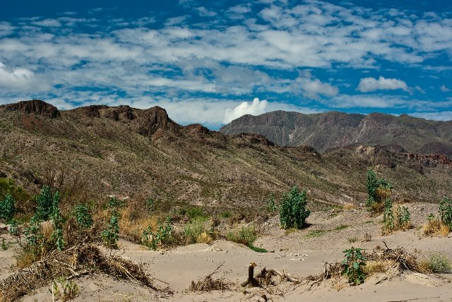 This photo shows part of the Chihuahuan desert along the Rio Grande. The terrain here is fairly rugged, with low mountains interrupting the landscape; vegetation cover in the low areas is sparse due to the low rainfall. These mountains rise only high enough to support low scrubby growth. Photo © Corey Leopold, CC BY 2.0, Source.
Plant Lists & In-Region Search
List Native Plants - List All Plants
Warning! This region extends outside the lower 48 US. We have only completed range maps for all plants in the lower 48 US; these lists and searches may thus have omissions for species which only occur in the portion of this region outside the lower 48 US.