
Home » Regions » North America » Eastern Temperate Forests » Mixed Wood Plains » Northern Allegheny Plateau » Delaware-Neversink Highlands
Delaware-Neversink Highlands
Last updated: September 11th, 2020
↑About the Delaware-Neversink Highlands
The Delaware-Neversink Highlands, referred to in some documents as the Northeastern Uplands, is a region in the northeastern corner of Pennsylvania, extending slightly into New York State to the north and east.This region consists of a dissected and glaciated plateau. It is similar in some respects to the Glaciated Low Allegheny Plateau to the west, but generally slightly steeper and higher-elevation, and with a higher density of lakes and bogs. The soils have formed on glacial till and outwash, which is in turn underlain by sandstone, siltstone, and shale. The soils here tend to be rocky and poorly-drained, and the poor drainage contributes to a greater density of wetlands. The portion of erosion-resistant sandstone in this region is greater than in the neighboring low plateau. This sandstone is the original or undeformed version of the deformed sandstone making up the Northern Sandstone Ridges running through much of the Appalachians.
The region has a humid continental climate. Precipitation here is significantly higher (by as much as 10-12 in / year) than areas to the west, and temperatures colder year-round. The growing season is short, only 130-140 days.
Original forest cover was mostly northern hardwood forest, with dominant species being sugar maple (Acer saccharum), yellow birch (Betula alleghaniensis), American beech (Fagus grandifolia), and eastern hemlock (Tsuga canadensis). The Woodbourne Forest and Wildlife Sanctuary contains some of the intact old-growth forest of this area. A small area along the Susquehanna river has some Appalachian oak forest.
There is relatively little farming here, owing to the short growing season and poor soils, and agriculture here is declining. The area is also sparsely populated; the largest town is Liberty, NY, and other towns include Windsor, NY, Monticello, NY, Callicoon, NY, and Hallstead, PA. All have population under 10,000. There is some tourism here, including vacation cabins. Although forest cover is higher than the region to the west, it is less than that in the nearby Poconos and Catskills.
This region is bordered to the south by the Low Poconos, to the northeast by the Catskills Transition, and to the northwest and southwest by the Glaciated Low Allegheny Plateau. There is also a small border to the southwest with the very end of the Northern Sandstone Ridges.
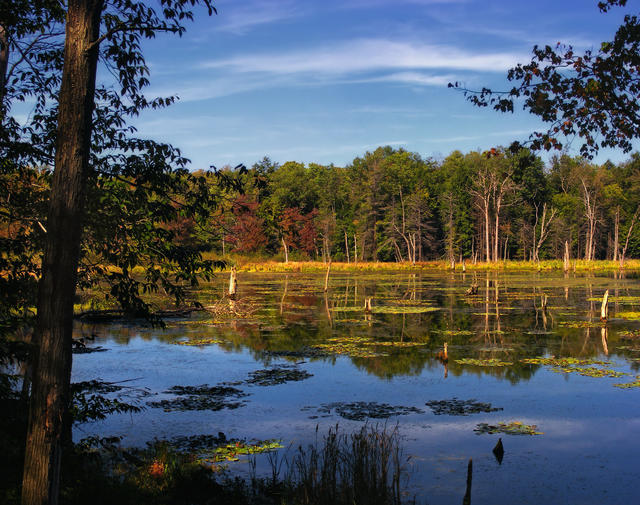 The Woodbourne Forest and Wildlife Preserve in this region, pictured here, has some old-growth forest; ponds like this are common throughout the region, although few of them have as intact flora in the surrounding forest as this one does. Photo © Nicholas A. Tonelli, CC BY 2.0.
Plant Lists & In-Region Search
We do not yet have data to generate plant lists for a region as fine-tuned as this one. However you can move up to the broader Northern Allegheny Plateau and generate lists for that region: native plants or all plants. Or search that region's plants here:
↑References
1. Bryce, S.A., Griffith, G.E., Omernik, J.M., Edinger, G., Indrick, S., Vargas, O., and Carlson, D. "Ecoregions of New York (Poster)", U.S. Geological Survey (2010) Web.
2. Woods, A.J, Omernik, J.M., Brown, D.D. "Level III and IV Ecoregions of Delaware, Maryland, Pennsylvania, Virginia, and West Virginia", U.S. Environmental Protection Agency: National Health and Environmental Effects Research Laboratory, Corvallis, OR (1999) Web.