
Home » Regions » North America » Eastern Temperate Forests » Ozark, Oauchita-Appalachian Forests » Ridge and Valley » Northern Sandstone Ridges
Northern Sandstone Ridges
Last updated: October 5th, 2020
Page contents
↑About the Northern Sandstone Ridges
The Northern Sandstone Ridges region makes up most of the major ridges of the northern portion of Ridge and Valley system; in the north they represent a large portion of the total land within this region. This region is the counterpart to the more southerly Southern Sandstone Ridges, a region that is geologically similar but distinguished by a change in forest type driven by climate.This regions consists of steep, forested ridges consisting of sandstone and conglomerate from the Paleozoic era, and narrow valleys. Side slopes consist of more erodable rocks like shale and siltstone. Ridgetop elevations reach to 2,740 ft (840m) at Tussey Mountain, PA, and are well over 2,000ft (610m) on many ridges. Within this region, even the floors of the small valleys between ridges are often much higher in elevation than the elevations outside this region, sometimes even over 2,000ft, but in other areas the streams cut deeply into softer layers underneath, leading to deep gorges that sometimes cut through the ridges and then drain out into surrounding lowlands. Soils here are quite variable even over short distances, but tend to be nutrient poor, sandy, and acidic. Plant growth here is shaped by low soil nutrients, soil acidity, rockiness, and steep slope angles.
The region has a humid continental climate, slightly cooler and with slightly higher precipitation than the surrounding lowlands.
Natural forest cover was probably Appalachian Oak Forest, contrasting with Oak-Hickory-Pine forest in the more southerly parts of this region.
This area is still mostly forested, owing to its steeper topography and poor suitability of its soils for agriculture. It is also sparsely populated. A small amount of farming can be found in an isolated, flatter part of this region where the ridges meet to form more of a dissected plateau, around Rosecrans, PA, an area that also features Rosecrans Bog Natural Area, a unique ecosystem found on one of the few poorly-drained sites in this region. In addition to this natural wetland, the region has several artificially-constructed reservoirs.
This region is interspersed with the lower, flatter Northern Shale Valleys, the lower, flatter, and agriculturally-fertile Northern Limestone/Dolomite Valleys, and the upland but geologically-distinct Northern Dissected Ridges and Knobs.
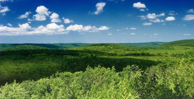 This photo near Gregg, PA shows typical scenery of this region: it is almost entirely forested, with ridgetops extending unbroken for miles. Photo © Nicholas A. Tonelli, CC BY 2.0.
Plant Lists & In-Region Search
We do not yet have data to generate plant lists for a region as fine-tuned as this one. However you can move up to the broader Ridge and Valley and generate lists for that region: native plants or all plants. Or search that region's plants here:
↑References
1. Woods, A.J, Omernik, J.M., Brown, D.D. "Level III and IV Ecoregions of Delaware, Maryland, Pennsylvania, Virginia, and West Virginia", U.S. Environmental Protection Agency: National Health and Environmental Effects Research Laboratory, Corvallis, OR (1999) Web.