
Home » Regions » North America » Eastern Temperate Forests » Ozark, Oauchita-Appalachian Forests » Central Appalachians » Uplands and Valleys of Mixed Land Use
Uplands and Valleys of Mixed Land Use
Last updated: September 8th, 2020
Page contents
↑About the Uplands and Valleys of Mixed Land Use
The Uplands and Valleys of Mixed Land Use represent the lower-elevation regions of the northern end of the Central Appalachians. Elevations here are still higher than areas farther northwest or southeast.This region consists of a dissected plateau: flat on a large scale but quite variable locally, with some flatter areas interspersed with low ridges and hills reaching to elevations of about 1,375-2,800 feet (419-853m). The bedrock is a mix of shale, siltstone, sandstone, and coal. Soils are variable but tend to be of low to moderate fertility with mesic or average moisture holding capacity.
Original cover was a mix of Appalachian Oak Forest on the warmer, drier sites, and the highly diverse Mixed Mesophytic Forest on the more mesic sites, with scattered bogs dominated by black spruce (Picea mariana) and tamarack (Larix laricina). Some of the original vegetation persists on isolated bogs, but the original forests have been cleared.
Currently there is some agriculture, mostly scattered and intermixed with sections of forest. There are some evergreen plantations for Christmas trees here. Agriculture here is currently on the decline and some cropland has been abandoned and is reverting to forest; most agriculture consists of dairy farming or the raising of livestock. Bituminous coal mining is common here and has resulted in stream acidification and degradation. About 60-70% of the present-day land is forested, either wild or in plantations, or in the process of reverting to forest.
Although not densely populated, this area is much more populous than the higher-elevation Forested Hills and Mountains, with which it is interspersed towards the northern end. In the far north, this region borders the Unglaciated High Allegheny Plateau, which is more forested and also has a greater density of oil wells. In the northwest, it borders the Pittsburgh Low Plateau, which is significantly lower in elevation, less rugged, and warmer. In the far south, in West Virginia, there is also a border to the west with the Monongahela Transition Zone, a region which averages lower elevation, and has a narrower range of local relief, i.e. with fewer flat areas as well as fewere of the steepest areas. There are also small borders with the Northern Dissected Ridges and Knobs and the Northern Shale Valleys.
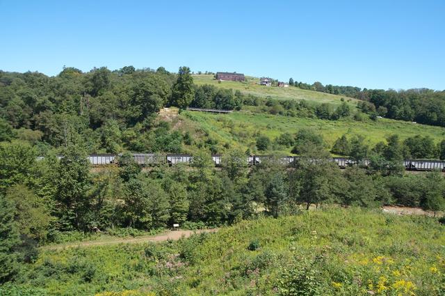 This landscape, with mixed land use and fairly young forests, is typical of this region, where much of the land is in the process of reverting back to forests. The freight train alludes to industry in the broader region. This particular site used to be a reservoir, destroyed in a dam failure that led to the the catastrophic Johnstown Flood of 1889. Photo © reivax (Flickr), CC BY-SA 2.0.
Plant Lists & In-Region Search
We do not yet have data to generate plant lists for a region as fine-tuned as this one. However you can move up to the broader Central Appalachians and generate lists for that region: native plants or all plants. Or search that region's plants here:
↑References
1. Woods, A.J, Omernik, J.M., Brown, D.D. "Level III and IV Ecoregions of Delaware, Maryland, Pennsylvania, Virginia, and West Virginia", U.S. Environmental Protection Agency: National Health and Environmental Effects Research Laboratory, Corvallis, OR (1999) Web.