
Home » Regions » North America » Eastern Temperate Forests » Ozark, Oauchita-Appalachian Forests » Western Allegheny Plateau » Pittsburgh Low Plateau
Pittsburgh Low Plateau
Last updated: January 2nd, 2020
Page contents
↑About the Pittsburgh Low Plateau
The Pittsburgh Low Plateau is the northeasternmost region within the Western Allegheny Plateau, and is mostly located within western Pennsylvania, with a small piece extending into eastern Ohio.This region is a well-dissected plateau, flat on a large scale, but locally hilly, with rounded hills, narrow valleys. Hilltops range from 1,100 to 1,400 feet (366-396m). Elevations tend to be lower than areas to the east and north, but higher than areas to the west.
The original forest cover here was probably mostly Appalachian oak forest with some mixed mesophytic forest in the south.
This area has been heavily developed for agriculture, which is interspersed with numerous small fragments of forest. There has also been significant mining of bituminous coal, which is abundant in this region, and there are some oil wells and gas fields as well. Some forests exist on abandoned mining sites. There is also significant urbanization and industry. This area contains part of the Pittsburgh metro area as well as some smaller cities; Pittsburgh lies on the southwest border of this region and part of its urban area extends into the neighboring Monongahela Transition Zone.
Acid mine drainage and other industrial pollution has degraded the waterways in this region, although the damage has been greater for fish populations than terrestrial plant life.
This region is bordered to the southwest by the Monongahela Transition Zone, which is somewhat irregularly interspersed with this region in the southeast. To the west, there is a small border with the Unglaciated Upper Muskingum Basin. To the northwest lies the Low Lime Drift Plain. To the north, this region borders the higher-altitude Unglaciated High Allegheny Plateau. To the east also lie higher-altitude areas, the Uplands and Valleys of Mixed Land Use in the north and the even higher-elevation Forested Hills and Mountains south of that.
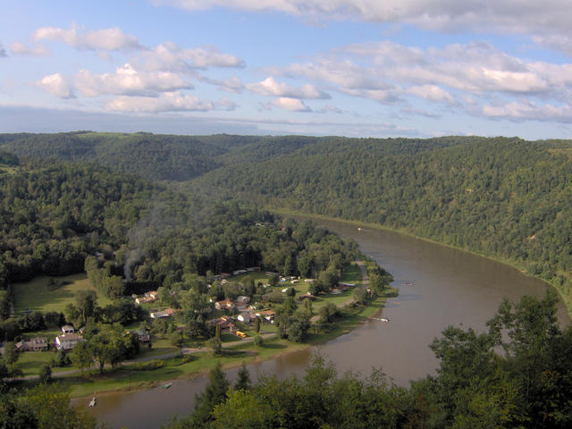 This photo, taken near East Brady, PA, shows the Allegheny river, a major feature in this region, winding through a typical landscape that is locally hilly but flat over a large spatial scale. Photo © Nyttend (Wikipedia), Public Domain.
Plant Lists & In-Region Search
We do not yet have data to generate plant lists for a region as fine-tuned as this one. However you can move up to the broader Western Allegheny Plateau and generate lists for that region: native plants or all plants. Or search that region's plants here:
↑References
1. Woods, A.J, Omernik, J.M., Brown, D.D. "Level III and IV Ecoregions of Delaware, Maryland, Pennsylvania, Virginia, and West Virginia", U.S. Environmental Protection Agency: National Health and Environmental Effects Research Laboratory, Corvallis, OR (1999) Web.