
Home » Regions » North America » Eastern Temperate Forests » Mississippi Alluvial & Southeast USA Coastal Plains » Middle Atlantic Coastal Plain » Virginian Barrier Islands and Coastal Marshes
Virginian Barrier Islands and Coastal Marshes
Last updated: September 1st, 2020
↑About the Virginian Barrier Islands and Coastal Marshes
The Virginian Barrier Islands and Coastal Marshes consists of the coastal areas along the Atlantic seashore, from Cape Henlopen at the southern end of the Delaware bay, south to about Duck, NC. This long, narrow region consists mostly of beaches, sand dunes, and barrier islands, and the margins of lagoons and bays, and tidal wetlands sometimes extending for quite some distance behind the barrier islands. Elevations are from 35ft (11m) to sea level.This region is directly exposed to the ocean, and as a result, its landforms are dynamic, characterized both by erosion and deposition of sediment. The shoreline tends to move west at a rate of about 5ft (1.5m) per year, but this may accelerate due to rising sea levels associated with global warming and/or more severe hurricanes.
Vegetation here consists of Northern Cordgrass Prairie, with Oak-Hickory-Pine forest on upland sites, and Atlantic Coastal Plain Maritime Forest on the richest coastal sites. Salt spray, high soil salinity, sand and clay soils, and low nutrient accumulation all severely limit plant growth. Plants here must also be adapted to hurricanes and other storms. The flat topography and severe storms cause the maximum tree height to be lower here than in areas farther inland. However, the proximity to the ocean and low elevation protects this region against severe winters, leading some plants to occur farther north in this region than they do inland. The combination of milder winter temperatures and nutrient-poor soils tends to favor evergreen vegetation, both in woody and herbaceous plants, so there is a greater portion of evergreens than areas farther inland.
This region has been threatened by extension beachfront development for vacation homes, which often removes forest and dune vegetation, leaving areas even more vulnerable to erosion.
On the Delmarva peninsula, this region is bordered inland by the Delmarva Uplands. The portion south of the Chesapeake bay is bordered inland by the Chesapeake-Pamlico Lowlands and Tidal Marshes, which also extends along the margins of the Chesapeake bay. To the south along the coast, it is bordered by the Carolinian Barrier Islands and Coastal Marshes. All of these borders are somewhat arbitrary and represent gradual transitions, but the transition to a different ecoregion inland is more abrupt than the gradual change in climate moving north and south along the coast. At its north end at Cape Henlopen, this region borders the Delaware River Terraces and Uplands which extend along the Delaware bay. North of the Delaware Bay, the ecologically-similar Barrier Islands/Coastal Marshes region extends along New Jersey and Long Island.
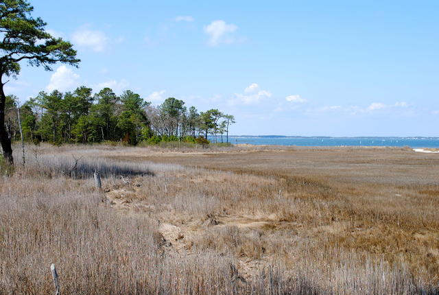 This photo shows the James Farm Ecological Preserve in Delaware; the estuary of the Indian river bay is visible in the background, and the scenery also includes brackish marshes and pine-dominated forests, a common sight on the sandy soils typical of this region. Photo © Lee Cannon, CC BY-SA 2.0.
Plant Lists & In-Region Search
We do not yet have data to generate plant lists for a region as fine-tuned as this one. However you can move up to the broader Middle Atlantic Coastal Plain and generate lists for that region: native plants or all plants. Or search that region's plants here:
↑References
1. Woods, A.J, Omernik, J.M., Brown, D.D. "Level III and IV Ecoregions of Delaware, Maryland, Pennsylvania, Virginia, and West Virginia", U.S. Environmental Protection Agency: National Health and Environmental Effects Research Laboratory, Corvallis, OR (1999) Web.