
Home » Regions » North America » Eastern Temperate Forests » Mississippi Alluvial & Southeast USA Coastal Plains » Middle Atlantic Coastal Plain
Middle Atlantic Coastal Plain
Last updated: October 5th, 2023
To check where a specific point lies, you can look it up in our Ecoregion Locator.
↑Map Legend & Subregion List
This list will help you navigate the regions in case you have problems with viewing or clicking the interactive map above.
† Status: ✓ = Complete ○ = Needs Image … = Incomplete ∅ = Stub Only
‡ This code refers to the US EPA's Level 4 ecoregion codes for the continental U.S., see here.
↑Progress
Partially Complete | With Images | Complete w/ Images |
Get involved! You can help our ecoregion articles progress faster. Help us find photos of these regions. Contact us if you have any additions or corrections to any of these articles. You can also donate to support our ongoing work.
↑About the Middle Atlantic Coastal Plain
The Middle Atlantic Coastal Plain is a region covering most of the coastal plain from the border of South Carolina and Georgia, northeast to southern New Jersey.The climate here is humid and subtropical, with continental influences as well as some moderation from the ocean. Summers are hot and winters mild. Frost and snow is common in the north, but becomes milder and less common in the south, although anywhere in this region can experience significant snowfall in a cold winter. The northern end of this region has essentially no seasonality of precipitation, but seasonality becomes stronger as one moves south, with a wet season starting June-July, peaking in August, and continuing through September. Because of the flat nature of this region and its surroundings, air masses can move freely across this region, so it can experience unpredictable changes in weather, including long spells that are much hotter, colder, wetter, or drier than is typical. The moderating effects of the ocean are also unpredictable, and can be minimized when air masses arrive from the continent, although there is greater ocean moderation in areas where barrier islands are separated from the mainland by large bodies of brackish water, the most dramatic example of this effect being Hatteras Island being separated by Pamlico Sound and a similar effect is seen at the southern tip of the Delmarva peninsula. This whole region is also subject to hurricanes and other tropical storms originating in the Atlantic ocean; the frequency and severity of these storms tends to increase to the south and in coastal areas.
This region tends to be flat and poorly-drained, with dunes, beaches, and barrier islands along the coastline, usually with extensive wetlands behind them. There are numerous estuaries, including the Chesapeake bay, the Delaware bay, and Pamlico and Albemarle sounds in North Carolina. Soils here tend to be highly acidic, due to a combination of substrates poor in calcium and magnesium, and further leaching of these nutrients from the warm, humid climate. The most common soil types here are ultisols on uplands, histosols (mucky or peaty soils formed mostly of organic matter) on swampy grounds and flatwoods, and some exposed sands along the coast. Although soil texture and drainage varies, the soil pH here is consistently low, and soils are low in mineral nutrients.
Original vegetation was mostly longleaf pine forest, and oak-hickory-pine forest to the north. Longleaf pine has been greatly reduced and mostly replaced with loblolly pine (Pinus taeda) and shortleaf pine (Pinus echinata). Lower, wetter areas supported American sweetgum (Liquidambar styraciflua), bald cypress (Taxodium distichum), pond cypress (Taxodium ascendens), and various bottomland oaks, all of which are still relatively common here. Southern barrier islands here support maritime forests of live oak (Quercus virginiana), sand laurel oak (Quercus hemisphaerica), and loblolly pine. Coastal marshes feature cordgrass, saltgrass (Distichlis spicata), and various rushes. Dunes are mostly covered in American beachgrass (Ammophila breviligulata) and sea oats (Uniola paniculata). Many plant species, including some predominately tropical species, reach their northernmost range limits in this region, mostly in the water-moderated coastal areas.
This area is heavily utilized for forestry, with large-scale pine plantations, used both for lumber and pulp. There is some cropland, with more in the north of the region, owing to the less leached soils. Crop production here include grains, potatoes, cotton, blueberries, and peanuts. Berry crops are able to thrive here in acidic, peaty, and mucky soils less suitable for other crops. Certain areas have intense poultry and pig farming, with pig farming particularly intense in North Carolina, and poultry farming common there as well as in South Carolina and on the Delmarva peninsula. This area has some urbanization, but none of the biggest metro areas of the East Coast; the largest urban area here is the Hampton Roads area (Virginia Beach-Norfolk-Newport News); the next-largest cities are Wilmington, NC, Greenville, NC, and Jacksonville, NC, and there are some smaller cities including Dover, DE, Salisbury, MD, New Bern, NC, and Myrtle Beach, SC. This region also has some major military installations throughout. Recreation and tourism is important here along the coast, although there is less intense residential development in coastal areas than regions farther north on the East Coast. Coastal development in this region is most intense in the north, owing to greater proximity to population centers.
Most of this region is bordered to the northwest (inland) by the Southeastern Plains, a slightly hillier, more upland area that represents the innermost portions of the coastal plain. At the northernmost part of this region, it directly borders the Northern Piedmont to the northwest, marked by a fall line corresponding to the end of the coastal plain; that region tends to be hillier and more geologically diverse, with soils forming on actual bedrock instead of on unconsolidated sediment. To the south, this region transitions into the Southern Coastal plain, and to the north, the Atlantic Coastal Pine Barrens. With the exception of the border with the Northern Piedmont, which is marked by a fall line, these borders are all somewhat arbitrary, representing gradual transitions rather than clear geological boundaries.
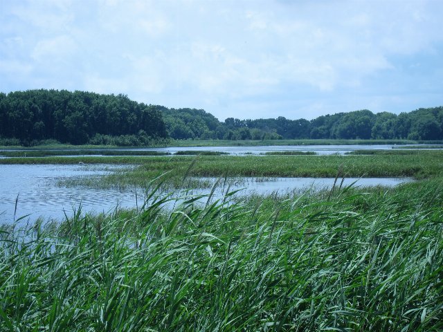 This photo shows Bombay Hook National Wildlife Refuge, one of the more intact areas of natural wetlands in the Middle Atlantic Coastal Plain. This flat region has a high concentration of wetlands, mostly set back slightly from the coast behind barrier islands, and/or draining into large estuaries and bays. Drier ground, in the background, is largely forested. Photo © loppear (Flickr), CC BY 2.0, Source.
Plant Lists & In-Region Search
↑References
1. Wiken, E., Griffith, G. "North American Terrestrial Ecoregions - Level III", Commission for Environmental Cooperation, (2011) Web.