
Home » Regions » North America » Eastern Temperate Forests » Southeastern USA Plains » Southeastern Plains » Chesapeake Rolling Coastal Plain
Chesapeake Rolling Coastal Plain
Last updated: July 24th, 2020
Page contents
↑About the Chesapeake Rolling Coastal Plain
The Chesapeake Rolling Coastal Plain is a region mostly located within central Maryland, and stretching northeast barely into Delaware and southwest through Washington D.C. and barely into Virginia. It is a hilly upland area, deeply dissected by streams. This region is better drained and has both higher elevation and relief than the Mid-Atlantic Coastal plain to the southeast, but has lower elevation and relief than the Piedmont area to the north. The underlying rock is sedimentary.Soils are mostly well-drained loams, and tend to be nutrient-poor, contrasting with the richer soils of the Piedmont. Although most of this area is well-drained, swamps occur in bottomlands along stream margins.
Naturally, this region was covered mostly by Oak-Hickory-Pine forest, with some Appalachian Oak Forests (dominated by northern red oak (Quercus rubra) and white oak (Quercus alba)) in the northeasternmost portion of this region. Presently much of the north and south of this region is covered in Coastal Plain Beech / Oak forest, with American beech (Fagus grandifolia), and there are also significant areas of Coastal Plain Pine - Mixed Hardwoods Lowland Forest. There is some Appalachian Oak Forest remaining in the south, but less than in the Piedmont Uplands to the northwest. Local bottomland areas have some mixed bottomland oak forests. This region is near the northern limit of willow oak (Quercus phellos) and southern limit of pin oak (Quercus palustris) and in the region where these species overlap in bottomlands. There are also a few sites dominated by tuliptree (Liriodendron tulipifera), mostly sheltered slopes near the Chesapeake bay. American sweetgum (Liquidambar styraciflua) is common throughout the region, especially on wetter sites, and dominant on a few sites as well.
Urbanization and suburban residential development is extensive in this region, which includes much of the Baltimore and Washington D.C. metro areas, as well as the smaller city of Annapolis. There is some agriculture as well, which is diversified and not particularly intensive. There are some large tracts of protected land here, including Elk Neck State Forest and the separate Elk Neck State Park, the Patuxent Research Refuge, and smaller areas at the Globecom Wildlife Management Area, Severn Run Natural Environment Area, and Calvert Cliffs State Park. The southern part of this region has the most extensive forest cover, most of it on private land.
The northwestern border of this region is abrupt, marked by a fall line, with the Piedmont Uplands to the northwest. The southern border of this region is the Potomac river, with the Rolling Coastal Plain on the southern shore. The border with the Delmarva Uplands at the far eastern end of this region is less well-defined, more of a gradual transition characterized primarily by the Delmarva Uplands having flatter topography and lower elevations. This border is mostly with the Chesapeake-Pamlico Lowlands and Tidal Marshes, but there is a small border at the far northeast of this region with the Delmarva Uplands as well. At several locations, such as the Calvert Cliffs, this region directly borders the Chesapeake bay with steep cliffs at the water's edge.
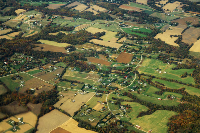 This aerial photo shows a more rural portion of this region around the town of Lothian Woods, with a mix of agriculture, forest, and residential development. Most of this region is more intensely suburbanized than the area pictured here. Photo © formulanone (Flickr), CC BY-SA 2.0.
Plant Lists & In-Region Search
We do not yet have data to generate plant lists for a region as fine-tuned as this one. However you can move up to the broader Southeastern Plains and generate lists for that region: native plants or all plants. Or search that region's plants here:
↑References
1. Woods, A.J, Omernik, J.M., Brown, D.D. "Level III and IV Ecoregions of Delaware, Maryland, Pennsylvania, Virginia, and West Virginia", U.S. Environmental Protection Agency: National Health and Environmental Effects Research Laboratory, Corvallis, OR (1999) Web.