
Home » Regions » North America » Eastern Temperate Forests » Ozark, Oauchita-Appalachian Forests » Ridge and Valley » Southern Dissected Ridges and Knobs
Southern Dissected Ridges and Knobs
Last updated: February 23rd, 2021
↑About the Southern Dissected Ridges and Knobs
The Southern Dissected Ridges and Knobs are a part of the Ridge and Valley system of the Appalachians. This region consists of numerous discontinuous pieces, extending from west-central Virginia through eastern Tennessee and northwestern Georgia, and an isolated section in northeastern Alabama. This region makes up a small portion of the Ridge and Valley system, much less than the adjacent valleys and sandstone ridges.This region consists of dissected ridges and isolated hills and knobs. Elevations here range from 500-1,300 feet, with local relief of 300-700 feet; this area averages lower and less rugged than the neighboring sandstone ridges, and the ridges here tend to be more broken. Streams are numerous, and inhabit narrow, sometimes winding and branching valleys, and tend to be moderate-to-high gradient. This region is underlain by a mix of shale, siltstone, sandstone, slate, quartzose limestone, and some chert. Soils here are mostly formed on cherty clay residuum, clay, silty clay, or sandy residuum formed from the decomposition of the underlying rocks. Although there is some diversity in soil texture and nutrient levels, soils here tend to be fairly leached owing to the warm, humid climate.
Original forest cover here was mostly mixed oak forest and oak-hickory-pine forest on the exposed ridges, with some mixed mesophytic forest on lower slopes and in more sheltered areas.
Presently there are some small areas of pasture and an even smaller amount of cropland on the flattest sites, but most of this area is left as wild forest.
This region is interspersed irregularly with the other portions of the Ridge and Valley system. The most common bordering region is the Southern Limestone/Dolomite Valleys and Low Rolling Hills, which is lower, flatter, and more agriculturally-fertile, and completely surrounds some of the portions of this region. There are also small borders with the low, but less agriculturally-fertile Southern Shale Valleys, and also with the Southern Sandstone Ridges, a higher, more rugged region that tends to have less broken ridges. In a few spots where this region borders the edge of the Ridge and Valley system, there is a border with the Southern Metasedimentary Mountains of the Blue Ridge, and with the Dissected Appalachian Plateau of the Central Appalachians.
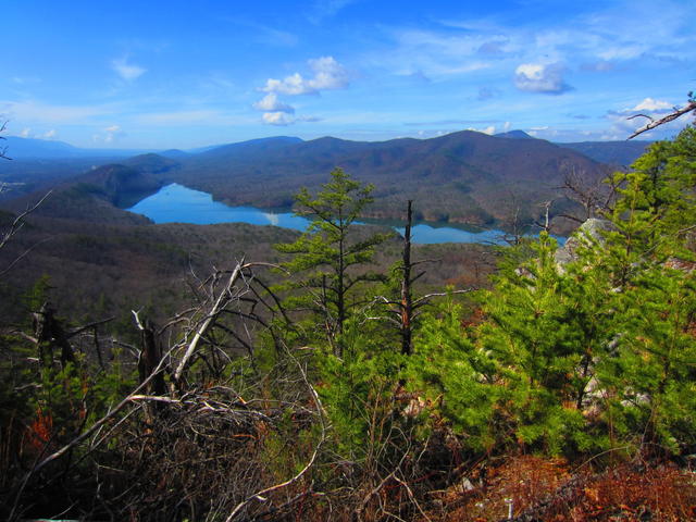 This photo of Carvins Cove Reservoir in Virginia shows the unique dissected terrain of the Southern Dissected Ridges and Knobs; most of the region is covered in deciduous forest, but there is some pine on the higher ridges. Photo © Raincrow (Flickr), CC BY 2.0, Source.
Plant Lists & In-Region Search
We do not yet have data to generate plant lists for a region as fine-tuned as this one. However you can move up to the broader Ridge and Valley and generate lists for that region: native plants or all plants. Or search that region's plants here:
↑References
1. Griffith, G.E.; Omernik, J.M.; and Azevedo, S.H. "Ecoregions of Tennessee (Poster)", U.S. Geological Survey, Reston, VA (1998) Web.
2. Griffith, G.E., Omernik, J.M., Comstock, J.A., Lawrence, S., Martin, G., Goddard, A., Hulcher, V.J., and Foster, T. "Ecoregions of Alabama and Georgia (color poster with map, descriptive text, summary tables, and photographs)", U.S. Geological Survey, Reston, VA (2001) Web.