
Home » Regions » North America » Eastern Temperate Forests » Ozark, Oauchita-Appalachian Forests » Ridge and Valley » Northern Glaciated Limestone Valleys
Northern Glaciated Limestone Valleys
Last updated: August 7th, 2020
↑About the Northern Glaciated Limestone Valleys
The Northern Glaciated Limestone Valleys are a region consisting of two disconnected, irregularly shaped pieces roughly stretching southwest-northesteast from eastern Pennsylvania, through northwestern New Jersey, and just into New York state.This region consists of broad, glaciated valleys and rounded hills. The terrain is rolling and uneven, and there is karst topography, with caves, sinkholes, and underground streams. Although limestone is the dominant substrate, it is mixed with shale and often under thin and discontinuous glacial till and drift. Rock outcroppings are common. Soils tend to be thin, but fertile, less leached of carbonates than the deeper soils of the unglaciated counterparts of this region to the southwest.
Natural forest cover here was sugar maple and mixed hardwood forest. Uplands were mostly dominated by sugar maple (Acer saccharum), with some white oak (Quercus alba), black oak (Quercus velutina), northern red oak (Quercus rubra), white ash (Fraxinus americana), tuliptree (Liriodendron tulipifera), and sweet birch (Betula lenta), yellow birch (Betula alleghaniensis), red maple (Acer rubrum), American basswood (Tilia americana), American beech (Fagus grandifolia), and hickories (Carya sp.). Understories included American hophornbeam (Ostrya virginiana), mapleleaf viburnum (Viburnum acerifolium), blackhaw (Viburnum prunifolium), northern spicebush (Lindera benzoin), and beaked hazelnut (Corylus cornuta). Forested wetlands supported red maple, yellow birch, green ash (Fraxinus pennsylvanica), basswood, tulip tree, and tupelo (Nyssa sylvatica).
Widespread agriculture has majorly reduced forest cover here, although there are still numerous small forest fragments interspersed with agriculture and residential development, as well as some larger tracts of forest on steeper slopes. Wallkill River National Wildlife Refuge is located in this region, and preserves a significant tract of land here.
This region is interspersed with the Northern Glaciated Shale and Slate Valleys. The northwestern portion borders the more rugged, forested Northern Glaciated Ridges to the northwest, whereas the southeastern portion borders the also-rugged-and-forested Glaciated Reading Prong and Hudson Highlands to the southeast. Only the southeastern portion of this region borders its unglaciated counterpart to the southwest, the Northern Limestone / Dolomite Valleys. This border represents an abrupt soil transition to deeper, but more leached soils.
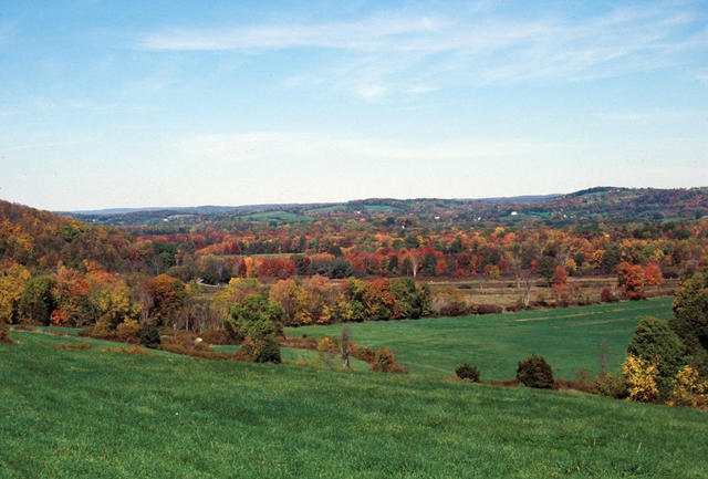 This view, taken from the Wallkill River National Wildlife Refuge, shows a gently rolling landscape with a mosaic of forest and other land use in this region; this region is less intensively farmed presently than the glaciated counterpart to this region farther southwest. Public domain photo by Kevin Holcomb, courtesy of the U.S. Fish and Wildlife Service, Public Domain.
Plant Lists & In-Region Search
We do not yet have data to generate plant lists for a region as fine-tuned as this one. However you can move up to the broader Ridge and Valley and generate lists for that region: native plants or all plants. Or search that region's plants here:
↑References
1. Woods, A.J., Omernik, J.M., Moran, B.C. "Level III and IV Ecoregions of New Jersey", (2007) Web.
2. Bryce, S.A., Griffith, G.E., Omernik, J.M., Edinger, G., Indrick, S., Vargas, O., and Carlson, D. "Ecoregions of New York (Poster)", U.S. Geological Survey (2010) Web.
3. Woods, A.J, Omernik, J.M., Brown, D.D. "Level III and IV Ecoregions of Delaware, Maryland, Pennsylvania, Virginia, and West Virginia", U.S. Environmental Protection Agency: National Health and Environmental Effects Research Laboratory, Corvallis, OR (1999) Web.