
Home » Regions » North America » Eastern Temperate Forests » Ozark, Oauchita-Appalachian Forests » Ridge and Valley » Northern Glaciated Shale and Slate Valleys
Northern Glaciated Shale and Slate Valleys
Last updated: March 20th, 2021
↑About the Northern Glaciated Shale and Slate Valleys
The Northern Glaciated Shale and Slate Valleys represent the more northeasterly, glaciated counterpart to the unglaciated Northern Shale Valleys. This region is small, and begins in a small portion of eastern Pennsylvania, extending through New Jersey into New York state up to the Hudson valley.This region consists of broad, irregularly-shaped valleys and rolling hills underlain by slate, shale, and sandstone, and covered with glacial drift. There are glacial lakes and wetlands in some areas, owing to the combination of impermeable shale and original drainage patterns disrupted by glaciation. The combination of poor drainage on bottomlands, and locally rugged terrain with thin soils prone to both erosion and drought make the suitability of land here for agriculture vary considerably from site to site.
This region was originally mostly forested, primarily in mixed oak, sugar maple, and northern hardwood forests. Sites with shallow soils over bedrock supported chestnut oak (Quercus montana), black oak (Quercus velutina), northern red oak (Quercus rubra), various hickories (Carya sp.), and tuliptree (Liriodendron tulipifera). Uplands with deeper soils supported sugar maple (Acer saccharum), white oak (Quercus alba), northern red oak, and black oak, white ash (Fraxinus americana), tuliptree, sweet birch (Betula lenta), yellow birch (Betula alleghaniensis), red maple (Acer rubrum), American basswood (Tilia americana), American beech (Fagus grandifolia), and hickories, with an understory of mapleleaf viburnum (Viburnum acerifolium), blackhaw (Viburnum prunifolium), northern spicebush (Lindera benzoin), and beaked hazelnut (Corylus cornuta). Wetter bottomland sites supported swamp forests of red maple, yellow birch, ash, basswood, tuliptree, and tupelo (Nyssa sylvatica).
Nowadays, most of this region has been developed for agriculture, primarily small grains, corn, and hay, with some woodlots on more sloped sites. Some forest cover remains, with more along steep slopes and in riparian areas. This area is not densely populated, containing mostly larger towns. Larger settlements include Middletown NY, Scotchtown, NY, Wantage NJ, and Chester, NY.
This area is bordered to the east by the Hudson Valley and to the northwest by the Northern Glaciated Ridges. To the southwest, at the limit of glaciation this region borders the unglaciated Northern Shale Valleys. The west of this region is bordered to the southeast by the Northern Glaciated Limestone Valleys, which also extend northwest of this region in a narrow strip along a small distance. At the easternmost point, this region is bordered to the south by the Glaciated Reading Prong/Hudson Highlands.
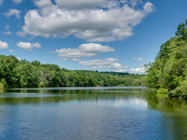 This photo shows Highland Lakes State Park, New York, one of the few less-developed areas within the region. The combination of impermeable shale substrate and history of glaciation has created many lakes throughout the region. Crop of a Photo © Wes Kania, CC BY 2.0, Source.
Plant Lists & In-Region Search
We do not yet have data to generate plant lists for a region as fine-tuned as this one. However you can move up to the broader Ridge and Valley and generate lists for that region: native plants or all plants. Or search that region's plants here:
↑References
1. Woods, A.J., Omernik, J.M., Moran, B.C. "Level III and IV Ecoregions of New Jersey", (2007) Web.
2. Bryce, S.A., Griffith, G.E., Omernik, J.M., Edinger, G., Indrick, S., Vargas, O., and Carlson, D. "Ecoregions of New York (Poster)", U.S. Geological Survey (2010) Web.
3. Woods, A.J, Omernik, J.M., Brown, D.D. "Level III and IV Ecoregions of Delaware, Maryland, Pennsylvania, Virginia, and West Virginia", U.S. Environmental Protection Agency: National Health and Environmental Effects Research Laboratory, Corvallis, OR (1999) Web.