
Home » Regions » North America » Eastern Temperate Forests » Ozark, Oauchita-Appalachian Forests » Ridge and Valley » Northern Glaciated Limestone Ridges, Valleys, and Terraces
Northern Glaciated Limestone Ridges, Valleys, and Terraces
Last updated: March 20th, 2021
↑About the Northern Glaciated Limestone Ridges, Valleys, and Terraces
The Northern Glaciated Limestone Ridges, Valleys, and Terraces, referred to in some documents as the Northern Glaciated Limestone Valleys and Terraces, is a small region extending northeast-southwest along the banks of the Delaware river, extending farther on the northwestern side of the river. It includes a portion in the easternmost portion of Pennsylvania, a long, narrow sliver in the northwesternmost part of New Jersey, and a narrow stretch in New York state. The region is widest at its western end, and narrowest in the middle.This region has diverse topography, including glaciated valleys, folded and faulted ridges, and fluvial terraces originating as floodplains from once-higher rivers. Underlying rocks are variable, including limestone, shale, and sandstone with the addition of glacial drift and till, and some loess and alluvium. Limestone areas have karst topography. The depth of glacial drift is highly variable across this region. Much of the region has fertile soils well-suited for agriculture, but there are local areas of less-fertile, acidic soil.
Original vegetation here was diverse, but sugar maple (Acer saccharum) was dominant throughout. The forest type has been mapped as Appalachian oak forest (more on the warmer sites and in the more southerly portion of this region) and oak-northern hardwood forest, but the forests here also shared some characteristics in common with the highly-diverse mixed mesophytic forests farther south. Uplands featured sugar maple, along with white oak (Quercus alba), black oak (Quercus velutina), and northern red oak (Quercus rubra), white ash (Fraxinus americana), tuliptree (Liriodendron tulipifera), sweet birch (Betula lenta), yellow birch (Betula alleghaniensis), red maple (Acer rubrum), American basswood (Tilia americana), American beech (Fagus grandifolia) and various hickories (Carya sp.) with understories of American hophornbeam (Ostrya virginiana) and American hornbeam (Carpinus caroliniana), mapleleaf viburnum (Viburnum acerifolium), blackhaw (Viburnum prunifolium), northern spicebush (Lindera benzoin), and beaked hazelnut (Corylus cornuta).
Significant parts of this region are preserved as part of the Delaware Water Gap National Recreation Area and the Walpack Fish and Wildlife Management Area. Outside of this protected land, the area is fairly developed for agriculture and residential development, in part because the bordering regions to the northwest and southeast between which this area is sandwiched are both so poorly-suited to agriculture and building. Stroudsburg and East Stroudsburg, PA are major settlements here. There is still some forest cover in these developed regions.
Along its entire length, this region is bordered to the southeast by the Northern Glaciated Ridges. To the northwest, this area borders the Low Poconos over the western portion, and at the northeasternmost portion, it borders the Catskills Transition to the northwest. At the southwestern end, this region borders the Northern Shale Valleys, and at the far northeast end, it borders the Hudson Valley to the east.
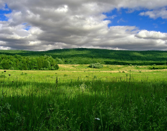 This photo shows the Walpack Valley in Sussex County, New Jersey, one of the lesser-developed parts of this region. Photo © Nicholas A. Tonelli, CC BY 2.0.
Plant Lists & In-Region Search
We do not yet have data to generate plant lists for a region as fine-tuned as this one. However you can move up to the broader Ridge and Valley and generate lists for that region: native plants or all plants. Or search that region's plants here:
↑References
1. Woods, A.J., Omernik, J.M., Moran, B.C. "Level III and IV Ecoregions of New Jersey", (2007) Web.
2. Bryce, S.A., Griffith, G.E., Omernik, J.M., Edinger, G., Indrick, S., Vargas, O., and Carlson, D. "Ecoregions of New York (Poster)", U.S. Geological Survey (2010) Web.
3. Woods, A.J, Omernik, J.M., Brown, D.D. "Level III and IV Ecoregions of Delaware, Maryland, Pennsylvania, Virginia, and West Virginia", U.S. Environmental Protection Agency: National Health and Environmental Effects Research Laboratory, Corvallis, OR (1999) Web.