
Home » Regions » North America » Eastern Temperate Forests » Ozark, Oauchita-Appalachian Forests » Southwestern Appalachians » Sequatchie Valley
Sequatchie Valley
Last updated: December 7th, 2020
↑About the Sequatchie Valley
The Sequatchie Valley is a long, narrow, low-lying region in the Southwestern Appalachians, surrounded by areas of higher elevation except where rivers cut across the broader region. The valley is narrow (about 4 miles wide) and straight, and extends northeast-southwest, stretching about twice as far north-south as it does east-west, and it extends from eastern Tennessee well into northeastern Alabama. Although separated from it geographically and having a simpler shape, this region is ecologically and geologically similar to the Southern Limestone/Dolomite Valleys and Low Rolling Hills in the Ridge and Valley system farther east.This region tends to be much lower and flatter than its surroundings, but its topography is still variable, ranging from nearly completely level bottomlands and adjacent terraces, through undulating terrain, to some hilly terrain. There are some alluvial fans where streams enter this area from narrow canyons cut in the adjacent higher-elevation plateaus. Streams tend to be low-to-moderate gradient, and there are a few springs. Geologically this region originated as the peak of an anticline; it is underlain by a mix of limestone, dolomite, and shale, and soils are mostly formed on cherty clay solution residuum derived from these rocks. Although the bedrock here is calcium-rich, the higher temperatures and rainfall here leads the soils here to be relatively more leached than more northerly regions whose soils formed on such calcium-rich rocks.
The climate is humid and subtropical, with a mild seasonality in precipitation: a drier season peaks in August, and precipitation is higher November through April.
This region was originally covered in Appalachian oak forest in the north, with a mix of oaks, hickory, pine, poplar, birch, and maple. In the south was the more diverse mixed mesophytic forest, with various oaks, elms, hickory, white ash (Fraxinus americana), maple, tupelo (Nyssa sylvatica), pines, American sweetgum (Liquidambar styraciflua), American basswood (Tilia americana), and American beech (Fagus grandifolia).
This region is heavily utilized for agriculture, including both cropland and pastureland. The main crops are hay, soybeans, wheat, small grains, corn, and tobacco. The central ridge of the region is mostly still forested, and the relative portion of forest cover tends to increase to the south, owing in part to the topography there being steeper. The region is more populous than the more rugged surrounding regions; the largest city is Scottsboro, AL, followed by Guntersville, AL, and there are a number of other smaller towns. The southern end of this region has been greatly altered by the Guntersville Dam on the Tennessee River, which created the artificial Guntersville Lake, now the largest lake in Alabama. This process submerged all of the lowest bottomlands in roughly the southern third of this region, and created a number of islands. Especially in the southernmost reaches of this region, the shoreline of the lake can be steep in places. This lake generally does not freeze, with the last complete bank-to-bank freeze recorded in 1940. The presence of the lake moderates the already-moderate climate here.
This region is surrounded by the Plateau Escarpment, a region transitional in the north to the Cumberland Plateau, and in the south, to the Southern Table Plateaus. At the southern end of this region, there is less elevation difference between this region and the bordering tablelands, and as such there is no well-defined escarpment, and this region directly borders the Southern Table Plateaus, and at the very southernmost end, the Dissected Plateau.
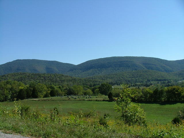 This photo shows a typical landscape of the Sequatchie Valley: level bottomlands, some adjacent hilly terrain, and steep walls surrounding the valley, with the low, flat land cleared but the hillier slopes remaining forested. Photo © Chris M Morris, CC BY 2.0, Source.
Plant Lists & In-Region Search
We do not yet have data to generate plant lists for a region as fine-tuned as this one. However you can move up to the broader Southwestern Appalachians and generate lists for that region: native plants or all plants. Or search that region's plants here:
↑References
1. Griffith, G.E.; Omernik, J.M.; and Azevedo, S.H. "Ecoregions of Tennessee (Poster)", U.S. Geological Survey, Reston, VA (1998) Web.
2. Griffith, G.E., Omernik, J.M., Comstock, J.A., Lawrence, S., Martin, G., Goddard, A., Hulcher, V.J., and Foster, T. "Ecoregions of Alabama and Georgia (color poster with map, descriptive text, summary tables, and photographs)", U.S. Geological Survey, Reston, VA (2001) Web.