
Home » Regions » North America » Eastern Temperate Forests » Ozark, Oauchita-Appalachian Forests » Southwestern Appalachians » Plateau Escarpment
Plateau Escarpment
Last updated: December 7th, 2020
↑About the Plateau Escarpment
The Plateau Escarpment is a region of the Southwestern Appalachians representing the transition from higher elevation Plateaus to the southeast, to the relatively lower elevations of the Interior Plateau to the northwest.This region is heavily dissected plateau, and consists of narrow ridges, knobs, cliffs, and steep gorges. The underlying geology is diverse, as this region cuts through many layers of rock, including sandstone, shale, siltstone, conglomerate, and coal at higher elevations and in the east, and in the west and at lower elevations, calcareous shale, limestone, and sandstone, Streams tend to be high-gradient, fast-flowing, and rocky-bottomed at the higher layers, whereas when they cut to the lower layers of limestone, valleys become broader, with nearly-level bottoms and karst topography. Rock outcroppings occur, mainly at higher elevations. At higher elevations, soils tend to be mineral-poor red clay soils, but fertile calcareous soils are found at lower elevations.
This region was originally almost entirely forested, with the highly diverse mixed mesophytic forest being common, but there also being a great deal of diversity in forest type with changing aspects and soil types. American chestnut (Castanea dentata) was dominant on drier sites. Upper slopes supported chestnut along with mixed oaks, including chestnut oak (Quercus montana), red maple (Acer rubrum), white oak (Quercus alba), and black oak (Quercus velutina).
Middle slopes, and lower north- and east-facing slopes supported mixed mesophytic forests with American beech (Fagus grandifolia), tuliptree (Liriodendron tulipifera), and sugar maple (Acer saccharum) as dominants, along with white oak, white ash (Fraxinus americana), American basswood (Tilia americana), yellow buckeye (Aesculus flava), and eastern hemlock (Tsuga canadensis), and cucumber tree (Magnolia acuminata), with numerous understory trees, shrubs, and herbs. In the south of this region, these associations also included American sweetgum (Liquidambar styraciflua), shortleaf pine (Pinus echinata), and Virginia pine (Pinus virginiana).
The warmest, middle and lower south- and west-facing slopes supported mixed oak forests, dominated mainly by white oak, with mountain laurel (Kalmia latifolia) understories, along with scarlet oak (Quercus coccinea), post oak (Quercus stellata), mockernut hickory (Carya tomentosa), pignut hickory (Carya glabra), tupelo (Nyssa sylvatica), and sourwood (Oxydendrum arboreum). Mesic coves and bottomlands supported mesophytic forest, or on some sites, eastern hemlock and magnolia with understory of rhododendron.
This area is still mostly forested, although there are small areas of cropland and pastureland, with the region producing livestock, corn, tobacco, and hay. The forests, however, have been extensively logged. There is also significant coal mine and gas extraction. However, steep slopes limit road building and logging. As such, the region has a patchy forest distribution with great diversity of land use from site to site. Some abandoned mining sites have been reclaimed, whereas others are barren. Some streams have extensive acidification from mine wastes, but other streams represent some of the most intact streams in the broader region. Reclaimed mine lands support black locust (Robinia pseudoacacia) and numerous planted species, including many introduced and invasive species such as tall fescue (Schedonorus arundinaceus).
Throughout the length of this region, it is bordered to the northwest by the flatter, lower-elevation Eastern Highland Rim. Most of the region is bordered to the southeast by the also flatter, but higher-elevation Cumberland Plateau; this border becomes increasingly irregular to the south. In the south, this region also surrounds the Sequatchie Valley over a long, narrow length. The southernmost region of this region borders the Southern Table Plateaus, mostly to the southeast, but also in an irregularly-shaped border. The far northern limit of this region has three small borders to the north with the Knobs-Norman Upland, Northern Forested Plateau Escarpment, and the Ohio/Kentucky Carboniferous Plateau to the east.
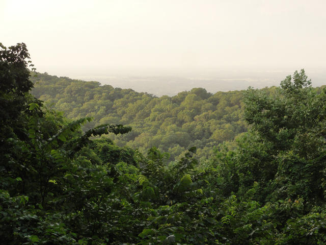 This view from atop Monte Sano, Alabama, shows the plateau escarpment of the southwestern Appalachians, a heavily-dissected region of narrow ridges and steep gorges, in the foreground, descending to the lower elevations of the interior plateau visible in the distance. Photo © Bart Everson, CC BY 2.0, Source.
Plant Lists & In-Region Search
We do not yet have data to generate plant lists for a region as fine-tuned as this one. However you can move up to the broader Southwestern Appalachians and generate lists for that region: native plants or all plants. Or search that region's plants here:
↑References
1. Woods, A.J., Omernik, J.M., Martin, W.H., Pond, G.J., Andrews, W.M., Call, S.M, Comstock, J.A., and Taylor, D.D. "Ecoregions of Kentucky (Poster)", U.S. Geological Survey, Reston, VA (2002) Web.
2. Griffith, G.E.; Omernik, J.M.; and Azevedo, S.H. "Ecoregions of Tennessee (Poster)", U.S. Geological Survey, Reston, VA (1998) Web.
3. Griffith, G.E., Omernik, J.M., Comstock, J.A., Lawrence, S., Martin, G., Goddard, A., Hulcher, V.J., and Foster, T. "Ecoregions of Alabama and Georgia (color poster with map, descriptive text, summary tables, and photographs)", U.S. Geological Survey, Reston, VA (2001) Web.