
Home » Regions » North America » Eastern Temperate Forests » Southeastern USA Plains » East Central Texas Plains
East Central Texas Plains
Last updated: April 11th, 2024
Page contents
To check where a specific point lies, you can look it up in our Ecoregion Locator.
↑Map Legend & Subregion List
This list will help you navigate the regions in case you have problems with viewing or clicking the interactive map above.
| Name | † | Color on Map | EPA Code‡ |
| Northern Post Oak Savanna | ○ | 33a | |
| Southern Post Oak Savanna | ○ | 33b | |
| San Antonio Prairie | ○ | 33c | |
| Northern Prairie Outliers | ○ | 33d | |
| Bastrop Lost Pines | ○ | 33e | |
| Floodplains and Low Terraces | ○ | 33f |
† Status: ✓ = Complete ○ = Needs Image … = Incomplete ∅ = Stub Only
‡ This code refers to the US EPA's Level 4 ecoregion codes for the continental U.S., see here.
↑Progress
Partially Complete | With Images | Complete w/ Images |
Get involved! You can help our ecoregion articles progress faster. Help us find photos of these regions. Contact us if you have any additions or corrections to any of these articles. You can also donate to support our ongoing work.
↑About the East Central Texas Plains
The East Central Texas Plains, also called the Post Oak Savannah (spelled with an "h") and the Texas Claypan Area is an irregularly-shaped region running loosely north-south in Texas, about from the town of Beeville in the south, north about to Durant, OK, near the OK-TX border. Historically this region was the southernmost portion of a belt of oak savannas that extended north into the upper Midwest, slightly into Canada. In the south, this region has an irregular U-shape where it mostly surrounds the Southern Blackland/Fayette Prairie.The climate here is towards the warm, dry end of a humid continental climate. Precipitation is weakly seasonal, with a wetter spring and fall, and drier summer and winter. Rainfall also decreases significantly moving westward through this region. The north of the region also has a wetter spring than fall, and the fall rainy season peaks in October, whereas in the south, the fall rainy season is more pronounced and peaks in September.
The terrain ranges from nearly flat to irregular rolling plains, and the landscape is moderately dissected by a low density of low-to-moderate gradient streams, flowing into several broad river systems. The waterways mostly have sandy bottoms, with a few silty. There are few natural lakes, but some larger reservoirs have been constructed by damming. The terrain is underlain by unconsolidated sediments spanning the Miocene (23.3 million years ago) through Paleocene (65 mya) epochs, with a few older sands from the Cretaceous in the north. The sediments include sands, silts, and clays. Soil texture varies throughout, but tends to follow a pattern of sands and sandy loams on uplands, with clay to clay-loam on bottomlands. Many areas have well-drained surface soils with a claypan beneath the surface, hindering water movement. Soils here tend to be acidic, contrasting with the blackland prairies to the west and interspersed in the south which have alkaline soils.
Prior to European colonization, this region was mostly covered in post oak savanna, with scattered trees and an understory of grasses. Tree density was patchy, with small stands of open forest on the richest sites. Trees were mostly post oak (Quercus stellata), blackjack oak (Quercus marilandica), or black hickory (Carya texana). Dominant grasses included little bluestem (Schizachyrium scoparium), purpletop (Tridens flavus), curly threeawn (Aristida desmantha), and yellow indiangrass (Sorghastrum nutans). Forest understory included a variety of shrubs, including yaupon (Ilex vomitoria), eastern redcedar (Juniperus virginiana), winged elm (Ulmus alata), American beautyberry (Callicarpa americana), and farkleberry (Vaccinium arboreum).
Historically, this region would have experienced frequent low-intensity fire, maintaining the savanna structure with large mature trees and an understory of grasses but with less brush and shrub growth. The combination of fire suppression and heavy livestock grazing has increased the cover of low-growing woody plants with poor fire-resistance, particularly Eastern redcedar in the north and honey mesquite (Prosopis glandulosa) in the south.
This region is significantly less-populated than the area to the west, but still has a number of smaller cities. Overall, land use here is much less intensive than areas to the west, but more than areas to the east. The bulk of the land is used for cattle production, including both pastureland and rangeland. There are also smaller amounts of cropland, producing hay, grain sorghum, corn, and wheat. Much of the present pastureland is on abandoned cropland. There are some open deciduous forests and also smaller fragmented woodlands throughout, with an irregular distribution. Forests are found both in uplands and bottomlands. The eastern margin of this region has a small amount of pine plantations.
Except at its southernmost end, this region is bordered to the west by the Texas Blackland Prairies, a region with more alkaline, finer-textured soils, that historically supported tallgrass prairie and is now the most populous and also intensively-farmed region in Texas. This region also mostly surrounds the Fayette Prairie section of that region in the south. At the southern end of this region, the border to the southwest is with the hotter, drier Southern Texas Plains. The south of this region borders the warm, humid, and flat Western Gulf Coastal Plain to the southeast. Most of this region borders the South Central Plains (Piney Woods) to the east. In the extreme north of this region there is a small border to the northwest with the Cross Timbers.
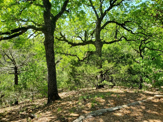 This landscape, showing post oak savanna at McKinney Rough Nature Park, is towards the hillier end of the East Central Texas Plains, and shows what a relatively more intact wild area looks like in this region. The soil texture leads to considerable drought stress, so tree growth is scattered and ample light reaches the ground, allowing for the growth of grasses and other plants. Cover is patchy, with some spots nearly-forested and others more open. Photo © , CC BY-SA 4.0.