
Home » Regions » North America » Great Plains » South Central Semi-Arid Prairies » Texas Blackland Prairies
Texas Blackland Prairies
Last updated: April 11th, 2024
Page contents
To check where a specific point lies, you can look it up in our Ecoregion Locator.
↑Map Legend & Subregion List
This list will help you navigate the regions in case you have problems with viewing or clicking the interactive map above.
| Name | † | Color on Map | EPA Code‡ |
| Northern Blackland Prairie | ○ | 32a | |
| Southern Blackland/Fayette Prairie | ○ | 32b | |
| Floodplains and Low Terraces | ○ | 32c |
† Status: ✓ = Complete ○ = Needs Image … = Incomplete ∅ = Stub Only
‡ This code refers to the US EPA's Level 4 ecoregion codes for the continental U.S., see here.
↑Progress
Partially Complete | With Images | Complete w/ Images |
Get involved! You can help our ecoregion articles progress faster. Help us find photos of these regions. Contact us if you have any additions or corrections to any of these articles. You can also donate to support our ongoing work.
↑About the Texas Blackland Prairies
The Texas Blackland Prairies are a region of East-Central Texas, and one of the most ecologically-devastated regions in Texas. Most of the region, the Northern Blackland Prairie, stretches north-south from near the Oklahoma border to about San Antonio. A smaller, discontinuous piece is also found to the southeast of the southernmost portion of this range, called the Southern Blackland/Fayette Prairie, stretching from west of the town of Yorktown, northeast to Montgomery. Although this region was once mostly-covered in prairies maintained by fire, it is now the most populous region of Texas and is also intensively farmed. Almost no natural prairie remains and what little does has been severely altered by a long history of fire suppression and the introduction of invasive species.The climate is towards the warm, dry end of a humid subtropical climate. Precipitation is weakly seasonal, following a bimodal pattern with wet seasons peaking in May-June and again in September-October, and drier summers and winters, but some rainfall occurring year-round. Although the region is mostly oriented north-south, it spans a large enough distance in the east-west direction, and precipitation changes more in this direction, such that rainfall is significantly higher in the east and lower in the west. The fall rainy season peaks also slightly earlier (late September) in the west of the region and later (October) in the east. Temperatures are warm to hot for much of the year. Both temperatures and precipitation are subject to unpredictable changes, including both short and long periods of higher or lower temperatures and/or rainfall than normal. These unpredictable changes can sometimes be more important than seasonal variation, especially as precipitation is concerned. Snowfall is rare, and usually light and short-lived, but does occur in some winters. There is only a slight difference in temperature from the northern to southern ends of this region, and it is mainly in the daytime highs being higher in the south; nighttime lows are nearly uniform throughout the region. Except in times of drought, relative humidity tends to be high, averaging over 65% even in the dry seasons.
The terrain here mostly varies from nearly-level to gently-sloping plains; the landscape is gently dissected by a well-developed network of low-to-moderate-gradient streams, including a mix of both intermittent and perennial streams. There are no natural lakes, but numerous artificial reservoirs have been constructed. The region is underlain by a mixture of chalk, claystone, marl, and shale, from the Cretaceous period, although in a few areas, newer deposits of sandstone and shale from the Miocene epoch are present. Although soil texture and fertility varies slightly throughout, most of the region has fine-textured clays rich in organic matter and mineral nutrients. The soils tend to be of the vertisol, mollisol, or alfisol orders. Vertisols form on sites with the greatest portion of expansive clay particles, which change volume in response to changes in their water content, leading to expansion and contraction, forming large cracks as soil dries out. These changes tend to stress plant growth and lead grassland species to dominate on sites that would normally have enough moisture to support trees. The vertisols also pose problems for construction, causing buildings to shift and need to be releveled. Mollisols and alfisols are less prone to these problems, and are ideal for agriculture. Reflecting the high mineral content, soil pH tends to be high, even relative to regions of similar rainfall. Most of the region's soil averages a pH of 8, high enough to significantly limit the species of plants that can grow here. Soil pH is even higher in bottomlands as calcium and magnesium tend to be carried downhill by water. However soil pH is patchy, and is lower on sites where the soils formed on certain less-common substrates such as shale or sandstone. The soils throughout tend to be prone to erosion, especially in the face of unsustainable agriculture, construction, and modern landscaping practices.
Before European colonization, this region was covered in tallgrass prairie, with the exception of bottomland areas which supported riparian forests. Dominant tallgrass prairie plants included little bluestem (Schizachyrium scoparium), big bluestem (Andropogon gerardii), indiangrass (Sorghastrum nutans), composite dropseed (Sporobolus compositus), eastern gamagrass (Tripsacum dactyloides), along with asters, clovers, black-eyed susan (Rudbeckia hirta), and many others. These prairies were maintained in large part by fire; fires were ignited both by lightning and by Native Americans. Fire occurred either in the winter, during the dormant season, or in summer. Summer fires were more likely to be severe and occur during periods of prolonged drought, and were usually ignited by lightning, whereas Native Americans were more likely to burn intentionally during the dormant season. Browsing by bison led to patchy fuel supply, which created variation in the effect that fires had on the grasslands.
Riparian forests included bur oak (Quercus macrocarpa), shumard oak (Quercus shumardii), sugarberry (Celtis laevigata), various elms (Ulmus), ashes (Fraxinus sp.), eastern cottonwood (Populus deltoides), and pecan (Carya illinoinensis). Outside riparian areas there were few natural wetlands, although there were some ephemeral areas of seasonally-wet prairie found in small depressions on uplands. Most of the larger expanses of bottomland areas are separated into the Floodplains and Low Terraces sub-ecoregion, but some smaller ones are interspersed throughout the other two sub-regions.
Almost no prairie remains here nowadays. There is relatively more bottomland forest remaining, with a composition similar to that of the original forests, but riparian buffers are narrow and completely absent in some places, with cropland or pastureland going right up to the edge of rivers or streams or even surrounding smaller streams. A long history of fire suppression has altered what few wild prairies remain. There are also numerous invasive species here, one of the most important of which is yellow bluestem (Bothriochloa ischaemum), which is referred to locally as "King Ranch bluestem". Nearly all the seasonal wetlands on upland sites have been drained as they tend to be located on richer sites ideal for agriculture; a few areas of wetlands have developed along the shores of some of the older reservoirs.
The ecosystems here once supported a great diversity of wildlife, including bison, pronghorn, wolves, cougars, ocelots, and greater prairie chickens. All of these species have been eliminated, primarily through habitat destruction. Animal species remaining here are mostly restricted to smaller animals, and include coyote, ringtail cat, armadillo, raccoon, skunk, eastern cottontail rabbits, plain pocket gophers, Texas toad, Texas horned lizard, and a variety of songbirds.
This is the most populous ecoregion in Texas, containing all of the San Antonio metro area, most of the Austin metro area, and the entire area around Dallas and Plano, but not including Fort Worth. On top of this there are numerous smaller cities, the largest of which is Waco, most of whose metro area is contained in this region. As with most of Texas, this region suffers from low-density car-oriented suburban development so these urban and suburban areas have a large land footprint relative to their population. Outside of the cities and their suburbs, the land is intensively farmed, including both cropland, pastureland, and rangeland. Dominant crops here include cotton, sorghum, corn, small grains, and hay. The portion of cropland here is higher than in the surrounding regions, reflecting the fertile soils and rainfall significantly higher than areas farther west. There is little public protected land here and little wild land remains throughout the area.
The southernmost part of the Northern Blackland Prairie is bordered to the west by the Edwards Plateau, and north of this it is bordered to the west by the Cross Timbers. The Northern Blackland Prairie is bordered to the east by the East Central Texas Plains, which also surrounds most of the Fayette Prairie, except at its northeasternmost end, where it is surrounded by the South Central Plains (Piney Woods). All of these regions are less-populous and less-intensively farmed than this one, and all have at least slightly more wild land, some more than others.
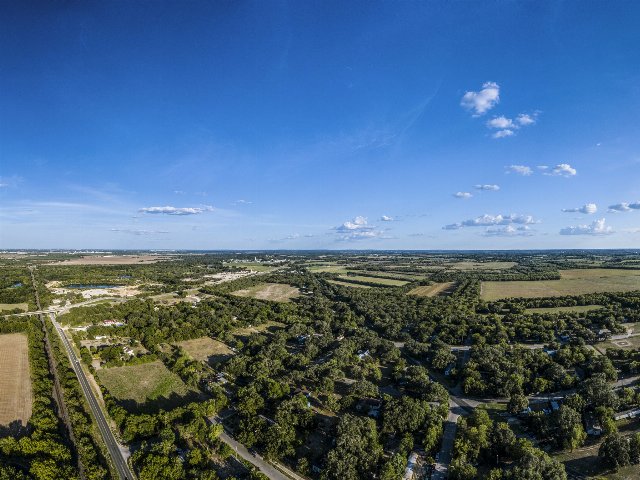 This aerial photo is taken from near the edge of the San Antonio Metro Area and shows a typical range of land uses in this region, spanning low-density suburban development to relatively intensive agriculture. The landscape is nearly entirely flat, and quite lush even after summer, reflecting this region's fertile soils and still somewhat abundant rainfall.
This photo was cropped from the original. Photo © U.S. Department of Agriculture, Public Domain, Source.