
Home » Regions » North America » Eastern Temperate Forests » Ozark, Oauchita-Appalachian Forests » Central Appalachians » Cumberland Mountain Thrust Block
Cumberland Mountain Thrust Block
Last updated: July 21st, 2020
↑About the Cumberland Mountain Thrust Block
The Cumberland Mountain Thrust Block is a region of the Central Appalachians that represents a chunk out of the Dissected Appalachian Plateau to the south of this region. It is relatively small, and mostly located in Kentucky, extending slightly into Tennessee, and with a narrow sliver in Virginia.This region was formed by a thrust fault which forced this region up above its surroundings. It has higher elevations, reaching to 4,145 ft (1,263 m) at Black Mountain, the highest point in Kentucky. Most of the region features steep slopes, narrow valleys, and coves. The northern border of this region consists of a single long, mostly unbroken ridge. South of this, the wider portions of this region consist of a more irregular dissected plateau. The bedrock is a mix of shale, siltstone, sandstone, and coal, with alluvium and colluvium on the surface in the valleys. Due to the steep slopes, topographic shading creates darker habitats in some areas, and brighter ones in others. An unusual flat basin, the Middlesboro Crater, formed by a meteorite impact, stands out from the rugged surroundings. There are also a few wider valleys along some of the larger rivers and streams.
This region was originally covered in mixed mesophytic forest with a high diversity of tree species, but the exact composition of this area in particular is not well-known. Tree cover varied considerably by site. american chestnut (Castanea dentata) was dominant on drier sites. Mesic sites probably supported American beech (Fagus grandifolia), tuliptree (Liriodendron tulipifera), sugar maple (Acer saccharum), white oak (Quercus alba), white ash (Fraxinus americana), eastern black walnut (Juglans nigra), buckeye, American basswood (Tilia americana), northern red oak (Quercus rubra), and numerous other plants. Drier slopes were probably dominated by white oak and hickory. Pines were found on shallow, sandy soils and steep sandstone slopes. Shady gorges featured eastern hemlock (Tsuga canadensis) and magnolia with an understory of rhododendron.
Most of this region has been repeatedly logged, and although present day forest cover is high, forests are second- or third-growth and differ from their original composition. Chestnut has been virtually eliminated due to blight. Regrowth forests consist of oaks, mostly white oak and black oak (Quercus velutina), sugar maple, red maple (Acer rubrum), tuliptree, eastern black walnut, black locust (Robinia pseudoacacia), hickory, white ash, American beech, black cherry (Prunus serotina), buckeye, eastern hemlock, and basswood. There is also extensive coal mining, including both surface and underground mines. Reclaimed mine lands are mostly covered in planted species, including the introduced/invasive tall fescue, the native black locust, and various introduced shrubs. Some unreclaimed mine lands are found here, and mine waste has severely degraded many of the streams. There is a small amount of pastureland. Most of this region is sparsely populated, but the area as a whole is more populous than its surroundings as it contains the small city of Middlesboro, KY and the smaller town of Harlan, KY.
This region is mostly surrounded by the Dissected Appalachian Plateau on all sides except the southeast, where it is bordered by a narrow ridge of the Southern Sandstone Ridges. Although the US EPA data shows this region directly bordering the Southern Limestone/Dolomite Valleys and Low Rolling Hills, this is a simplification or error, and the sandstone ridge actually covers the entire boundary of this region.
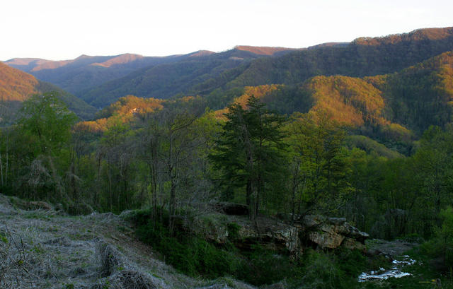 This photo shows the Kentucky side of Black Mountain and shows one of the more intact, protected regions of the Cumberland Mountain Thrust Block, with its steep slopes and heavily-dissected terrain. This photo was taken by Matt Wasson of Appalachian Voices, an organization that works to protect and restore the ecosystems in Appalachia. Photo © Matt Wasson, Appalachian Voices, CC BY 2.0, Source.
Plant Lists & In-Region Search
We do not yet have data to generate plant lists for a region as fine-tuned as this one. However you can move up to the broader Central Appalachians and generate lists for that region: native plants or all plants. Or search that region's plants here:
↑References
1. Woods, A.J., Omernik, J.M., Martin, W.H., Pond, G.J., Andrews, W.M., Call, S.M, Comstock, J.A., and Taylor, D.D. "Ecoregions of Kentucky (Poster)", U.S. Geological Survey, Reston, VA (2002) Web.
2. Griffith, G.E.; Omernik, J.M.; and Azevedo, S.H. "Ecoregions of Tennessee (Poster)", U.S. Geological Survey, Reston, VA (1998) Web.