
Home » Regions » North America » Eastern Temperate Forests » Ozark, Oauchita-Appalachian Forests » Central Appalachians » Dissected Appalachian Plateau
Dissected Appalachian Plateau
Last updated: August 3rd, 2020
↑About the Dissected Appalachian Plateau
The Dissected Appalachian Plateau, referred to in some sources as the Cumberland Mountains, is a large, strongly dissected and extensively forested region making up much of the southwestern portions of the Central Appalachians. Parts of this region have been severely degraded by coal mining. The region extends from West Virginia through parts of Virginia and Kentucky, into Tennessee.The region is relatively flat on a large scale, but locally very rugged. The crest elevations range from 1,200 to 3,600 feet (366-1,097m), and tend to be about 350-550 feet (107-168m) above the valleys. Slopes are steep and both ridges and valleys are narrow. What little flat land exists is limited to narrow floodplains of larger streams and rivers. The bedrock consists of sandstone, siltstone, shale, and coal. Soils tend to be well-drained, and range from moderate to low fertility.
The climate is humid and subtropical, with high precipitation, roughly equally distributed throughout the year, with a weak dry season in autumn. The frost-free growing season varies considerably by elevation and latitude, ranging from 195 days to 160 and possibly shorter.
This region was originally covered mostly in diverse and variable mixed mesophytic forest. American chestnut (Castanea dentata) was dominant on dry sites. Middle and lower north- and east-facing slopes featured American beech (Fagus grandifolia), tuliptree (Liriodendron tulipifera), and sugar maple (Acer saccharum) as dominants, and co-dominants including white oak (Quercus alba), ash, american basswood (Tilia americana), buckeye, eastern hemlock (Tsuga canadensis), and magnolia, along with diverse understories of small trees, shrubs, and herbs. Upper slopes featured mixed oak forests with chestnut oak (Quercus montana), red maple (Acer rubrum), white oak, and black oak (Quercus velutina). Warmer, middle and lower south- and west-facing slopes featured mixed oak forests dominated mainly by white oak, with understory of mountain laurel (Kalmia latifolia), along with black oak, scarlet oak (Quercus coccinea), post oak (Quercus stellata), mockernut hickory (Carya tomentosa), pignut hickory (Carya glabra), tupelo (Nyssa sylvatica), and sourwood (Oxydendrum arboreum). Mesic coves and bottomlands were co-dominated by hemlock and magnolia with an understory of rhododendron.
This area has been extensively logged, but it has mostly reverted back to woodland and about 90% of the region is presently forested or in the process of forest regeneration. A large portion of the forest, however, is managed as commercial woodlands. The remaining land is mostly used for coal mining, which has caused significant stream degradation. Mining techniques here include mountaintop removal, contour mining (a form of strip mining), and deep mining. There are some scattered small towns and some agriculture in the wider valleys. Agriculture here produces livestock, hay, tabacco, and corn. Reclaimed mining land supports many planted species including the introduced/invasive tall fescue, black locust (Robinia pseudoacacia), and many introduced shrubs. Some former mining sites are still barren.
This region is bordered to the northeast by the Forested Hills and Mountains, which is higher in average elevation and less dissected. There is a small border to the east with the Greenbrier Karst, an area of karst topography and limestone soils. In the south, this region partly surrounds the Cumberland Mountain Thrust Block. Where it does not, the border to the southeast is with the diverse Ridge and Valley region of the Appalachians. To the northwest, this region borders the Monongahela Transition Zone in the north, and the Ohio/Kentucky Carboniferous Plateau a bit southwest of that. At the southwestern end, this region borders the Cumberland Plateau to the west.
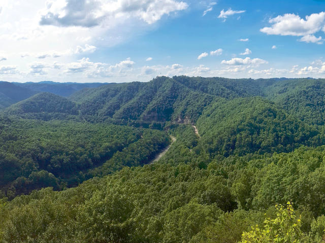 This dramatic view from Breaks Interstate Park on the border of Kentucky and Virginia shows the nearly-fully forested landscape and the steep, heavily-dissected landforms of this region. A single road, Route 80, follows the valley carved out by the Russell Fork river. Photo © Sarah (Guest Blogger), Virginia State Parks, CC BY 2.0, Source.
Plant Lists & In-Region Search
We do not yet have data to generate plant lists for a region as fine-tuned as this one. However you can move up to the broader Central Appalachians and generate lists for that region: native plants or all plants. Or search that region's plants here:
↑References
1. Woods, A.J, Omernik, J.M., Brown, D.D. "Level III and IV Ecoregions of Delaware, Maryland, Pennsylvania, Virginia, and West Virginia", U.S. Environmental Protection Agency: National Health and Environmental Effects Research Laboratory, Corvallis, OR (1999) Web.
2. Woods, A.J., Omernik, J.M., Martin, W.H., Pond, G.J., Andrews, W.M., Call, S.M, Comstock, J.A., and Taylor, D.D. "Ecoregions of Kentucky (Poster)", U.S. Geological Survey, Reston, VA (2002) Web.
3. Griffith, G.E.; Omernik, J.M.; and Azevedo, S.H. "Ecoregions of Tennessee (Poster)", U.S. Geological Survey, Reston, VA (1998) Web.