
Home » Regions » North America » Eastern Temperate Forests » Ozark, Oauchita-Appalachian Forests » Central Appalachians
Central Appalachians
Last updated: July 3rd, 2026
To check where a specific point lies, you can look it up in our Ecoregion Locator.
↑Map Legend & Subregion List
This list will help you navigate the regions in case you have problems with viewing or clicking the interactive map above.
| Name | † | Color on Map | EPA Code‡ |
| Forested Hills and Mountains | ✓ | 69a | |
| Uplands and Valleys of Mixed Land Use | ✓ | 69b | |
| Greenbrier Karst | ✓ | 69c | |
| Dissected Appalachian Plateau | ✓ | 69d | |
| Cumberland Mountain Thrust Block | ✓ | 69e |
† Status: ✓ = Complete ○ = Needs Image … = Incomplete ∅ = Stub Only
‡ This code refers to the US EPA's Level 4 ecoregion codes for the continental U.S., see here.
↑Progress
Partially Complete | With Images | Complete w/ Images |
Get involved! You can help our ecoregion articles progress faster. Contact us if you have any additions or corrections to any of these articles. You can also donate to support our ongoing work.
↑About the Central Appalachians
The Central Appalachians are a region of the Appalachians extending roughly northeast-southwest, from central Pennsylvania barely into Tennessee. The region is largest in eastern Kentucky and southern West Virginia. This region is higher-altitude and has steeper inclines than regions both to the northwest and southeast, and it features some of the highest elevations in the northern end of the Ozark, Oauchita-Appalachian Forests ecoregion, although farther south the Blue Ridge reaches much higher.The climate is humid and continental, with severe winters and warm to sometimes hot summers. The frost-free period can be as short as 130 days and is usually at most 180 days. Precipitation varies considerably by altitude, from about 38-59 inches annually. The terrain is rugged, consisting of a dissected plateau with numerous long ridges running through it. The ridges are narrow and steep, and the rest of the region is covered by low mountains and high hills, with narrow, curvy valleys. A few isolated flatter valleys are found throughout, from limestone and one meteorite crater.
Originally this region was covered in the highly diverse mixed mesophytic forest, with American chestnut (Castanea dentata) as the most common tree, but numerous other species common. Now, dominant trees include chestnut oak (Quercus montana), red maple (Acer rubrum), white oak (Quercus alba), black oak (Quercus velutina), American beech (Fagus grandifolia), tuliptree (Liriodendron tulipifera), sugar maple (Acer saccharum), American basswood (Tilia americana), buckeye, and eastern hemlock (Tsuga canadensis). White ash (Fraxinus americana) was common until recently when the Emerald Ash Borer killed most mature trees. There is some eastern white pine (Pinus strobus), mostly on north-facing slopes, and Virginia pine (Pinus virginiana) in early-successional growth. The highest elevations have some coniferous forest, dominated by red spruce (Picea rubens) and smaller amounts of balsam fir (Abies balsamea).
This area is less developed than the surrounding, flatter, lower-elevation areas. Most of the area is still forested, with only small amounts of pasture and dairy farming. Coal mining is common. The population is sparse, but there are small cities and towns throughout, mostly located in valleys and local areas of flatter topography. The largest cities are Beckley, WV, Johnstown, PA, and Middlesboro, KY.
To the southeast, this region is bordered by the lower-elevation and more populous Ridge and Valley region where the substrates are organized linearly. To the northwest, it is bordered by the lower and slightly less rugged Western Allegheny Plateau. At its southwestern end, this region borders the Southwestern Appalachians, and at its northern end, the North Central Appalachians.
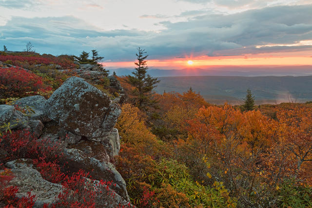 The Central Appalachians have higher elevations than areas to the east or west; some conifers are found at the higher elevations, but most of the region is covered in deciduous forest. Pictured here is Bear Rocks at Dolly Sods Wilderness, WV, an area that reaches over 4,000'. Photo © Nicolas Raymond, CC BY 2.0, Source.
Plant Lists & In-Region Search
↑References
1. Wiken, E., Griffith, G. "North American Terrestrial Ecoregions - Level III", Commission for Environmental Cooperation, (2011) Web.