
Home » Regions » North America » Eastern Temperate Forests » Ozark, Oauchita-Appalachian Forests » Western Allegheny Plateau » Monongahela Transition Zone
Monongahela Transition Zone
Last updated: March 20th, 2021
↑About the Monongahela Transition Zone
The Monongahela Transition Zone is a donut-shaped region, elongated in a northeast-southwest direction, located within the Western Allegheny Plateau, mostly located in West Virginia and southeast Ohio, with a significant portion in southwest Pennsylvania as well.This region is underlain by limestone, shale, sandstone, and coal of the Monongahela formation. The soils formed from this substrate are more base-saturated than those of the Pittsburgh Low Plateau. Although this creates soils better-suited for agriculture, the steeper topography limits areas available for farming.
This area was probably originally covered mostly by mixed mesophytic forest, with some mixed oak forest on the drier uplands, and some areas of beech forest in the broader, flatter valleys.
The original forests here have been cleared. Extensive forest still remains, but its composition has changed, with much less mixed mesophytic forest remaining nowadays. Most forests remaining are mixed oak with an understory of red maple, and there are some red maple-black ash swamps, with black ash now threatened by the emerald ash borer. There is significant industry and urban and suburban development, and a small amount of agriculture, all of which is mostly located in river valleys. Industry and acid mine drainage has degraded waterways in this region, although the soil minerals here provide a better buffer against acidification than in the Pittsburgh low plateau. Pittsburgh lies just outside this region to the northeast, and part of the Pittsburgh metro area is contained within this region. There are also artificial reservoirs in this area, including Beech Fork Lake and Stonewall Jackson lake, constructed for flood control, and Stonecoal Lake, originally used as a reservoir for a local coal-burning plant.
This region entirely surrounds the higher-elevation and more rugged Permian Hills. Is bordered to the northeast by the Pittsburgh Low Plateau, which is irregularly interspersed with it in a few spots. To the northwest lies the Unglaciated Upper Muskingum Basin, to the west the Ohio/Kentucky Carboniferous Plateau. These borders represent changes in underlying geologic substrate and soil type. To the southeast, this region is bordered by various regions of the Central Appalachians, generally higher in elevation and cooler.
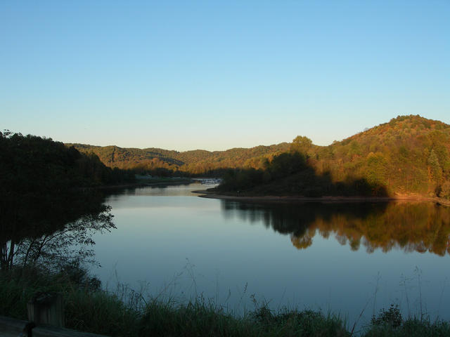 Stonewall Jackson Lake is one of several artificial reservoirs in this region. This photo also shows the hilly, forested landscape typical of this region. Photo © WVhybrid (Wikipedia), CC BY-SA 3.0.
Plant Lists & In-Region Search
We do not yet have data to generate plant lists for a region as fine-tuned as this one. However you can move up to the broader Western Allegheny Plateau and generate lists for that region: native plants or all plants. Or search that region's plants here:
↑References
1. Woods, A.J, Omernik, J.M., Brown, D.D. "Level III and IV Ecoregions of Delaware, Maryland, Pennsylvania, Virginia, and West Virginia", U.S. Environmental Protection Agency: National Health and Environmental Effects Research Laboratory, Corvallis, OR (1999) Web.
2. Woods, A.J., Omernik, J.M., Martin, W.H., Pond, G.J., Andrews, W.M., Call, S.M, Comstock, J.A., and Taylor, D.D. "Ecoregions of Kentucky (Poster)", U.S. Geological Survey, Reston, VA (2002) Web.