
Home » Regions » North America » Eastern Temperate Forests » Southeastern USA Plains » Interior Plateau » Inner Bluegrass
Inner Bluegrass
Last updated: September 15th, 2020
Page contents
↑About the Inner Bluegrass
The Inner Bluegrass region is part of the Interior Plateau located entirely within Kentucky. This region is relatively flat, agriculturally-fertile, and heavily utilized both for agriculture and urban, suburban, and industrial development. Previously a highly diverse region, this is now one of the more altered and degraded ecoregions. Forests here have been mostly cleared and there is little wild land remaining.This region consists mostly of relatively flat plains, and was never glaciated. The terrain ranges from nearly level in regions, to rolling plains, but there are steep gorges along the Kentucky and Dix rivers. In upland regions, there is a mix of some perennial streams and a larger number of intermittent streams. There is extensive karst topography, owing to the presence of limestone. Sinking streams, underground drainage, springs, sinkholes, and ponds are common.
The climate is towards the cooler end of a humid subtropical climate, with some continental influence due to the interior location. Precipitation is weakly seasonal, peaking in May and then declining to a low in September, but with some precipitation year-round on average. The bedrock is mostly phosphate-rich limestones and calcareous shales; soils on upland sites tend to be highly fertile, although some nutrient-poor soils can be found on floodplains.
This region was originally covered with open woodlands, savannas, and swamp forest. Uplands mostly supported open forest of blue ash (Fraxinus quadrangulata), white oak (Quercus alba), Shumard's oak (Quercus shumardii), eastern black walnut (Juglans nigra), chinquapin oak (Quercus muehlenbergii), bur oak (Quercus macrocarpa), shellbark hickory (Carya laciniosa), and kentucky coffeetree (Gymnocladus dioicus). Gorges supported oak-maple forests, with white oak, northern red oak (Quercus rubra), scarlet oak (Quercus coccinea), black oak (Quercus velutina), chinquapin oak, white ash (Fraxinus americana), sugar maple (Acer saccharum), red maple (Acer rubrum), and eastern redcedar (Juniperus virginiana). Poorly-drained sites in floodplains supported American sweetgum (Liquidambar styraciflua), pin oak (Quercus palustris), tuliptree (Liriodendron tulipifera), box elder (Acer negundo), and common hackberry (Celtis occidentalis). Sinkholes supported American sycamore (Platanus occidentalis), black locust (Robinia pseudoacacia), common hackberry (Celtis occidentalis), and red mulberry (Morus rubra). Throughout this region, giant cane (Arundinaria gigantea) is an important understory plant.
Most of this area has been cleared. Pastureland and cropland are the dominant uses throughout the region; the region is particularly well-known for breeding and raising of Thoroughbred horses for racing; it also produces cattle, burley tobacco, corn, and hay. There is also significant urban development, including both suburbs and industry. The Lexington metro area is contained entirely within this region, and the region also contains the smaller cities of Nicholasville and Georgetown; the small city of Winchester also straddles the border of this region. There are also numerous small towns.
Present forest cover here is minimal. Abandoned agricultural land supports early-successional fields of broomsedge bluestem (Andropogon virginicus) and sumac (Rhus sp.). These are replaced by forests of eastern redcedar and black locust, which may eventually develop into communities more typical of the original forests of this region. There is little protected wild land here; most of the parks in this region consist of cleared land. The few remaining forests are mostly in the steep ravines at the margins of this region.
This region is surrounded to the north, west, and south by the Hills of the Bluegrass. To the east and northeast, it also has a direct border with the Outer Bluegrass, which mostly surrounds the hilly region to the north and west as well.
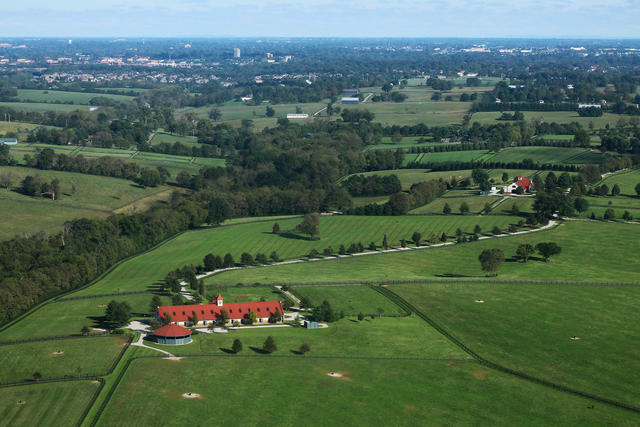 This photo, taken near Lexington, KY, shows a landscape typical of the Inner Bluegrass region, with mostly pastureland and cropland, particularly horse farms, some suburbanization, and only small, scattered forest fragments. Photo © formulanone (Flickr), CC BY-SA 2.0, Source.
Plant Lists & In-Region Search
We do not yet have data to generate plant lists for a region as fine-tuned as this one. However you can move up to the broader Interior Plateau and generate lists for that region: native plants or all plants. Or search that region's plants here:
↑References
1. Woods, A.J., Omernik, J.M., Martin, W.H., Pond, G.J., Andrews, W.M., Call, S.M, Comstock, J.A., and Taylor, D.D. "Ecoregions of Kentucky (Poster)", U.S. Geological Survey, Reston, VA (2002) Web.