Home » Regions » North America » Northwestern Forested Mountains » Boreal Cordillera » Watson Highlands
Watson Highlands
Last updated: February 21st, 2024
Page contents
↑About the Watson Highlands
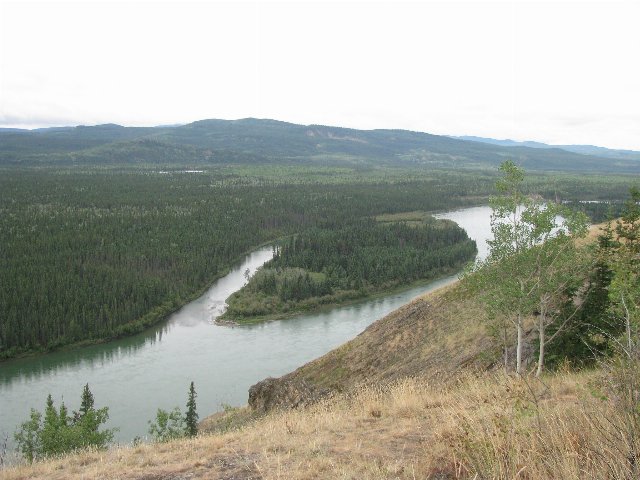
The Watson Highlands form a region in southwestern Yukon, extending slightly into northernmost British Columbia.The climate here ranges from dry-summer subarctic in the west to subarctic in the east, with a tundra climate at high elevations. The extensive, high coastal mountains to the southwest create rain shadow more dramatically than in areas farther south. Annual precipitation is as low as 225mm (8.9 in) in some of the valleys, but can reach to 1000mm (39 in) at high elevations. These mountains also insulate this region from most of the moderating effect of the ocean, although the southwest of this region still has more moderate winters than interior regions, leading the low elevations around Whitehorse to have the mildest winters in the region. Permafrost is extensive throughout, but discontinuous and irregular. Soils here vary in their mineral content based on different geologic substrates; most formed under forests and are relatively well-developed and well-drained, but soils on the colder sites are shaped by permafrost and these soils tend to hinder plant growth.
Terrain varies between rolling hills interspersed with small groups of rugged mountains, to nearly-level tablelands sparsely dissected by occasional valleys. This region has been heavily shaped by recent glaciation, and both moraines and deposits originating from glacial meltwater are common throughout. The drainage network is poorly-developed and the density of streams is low-to-moderate. Valleys are broad and irregular, with small streams relative to the valley sizes, and often numerous small lakes and wetlands interspersed throughout these same valleys. The upper portions of the watersheds of the Yukon and Liard rivers are found here. Soils here mostly formed under forests and are well-developed and mostly well-drained, and vary in their mineral content based on underlying substrate. However, some areas with permafrost have soils less suited for plant growth.
Vegetation cover here is limited by both cold temperatures and, on well-drained sites, low precipitation. Lower elevations feature open forests with white spruce (Picea glauca) as the dominant tree, interspersed with dwarf growth of willow, birch, ericaceous shrubs, and occasionally, lodgepole pine (Pinus contorta). Poorly-drained sites, which are common here, feature black spruce (Picea mariana), scrub willow, birch, and moss. Higher elevations feature subalpine fir and lodgepole pine. Above the tree line, alpine meadows feature mountain-avens (Dryas sp.), scrub growth of willow, birch, and ericaceous shrubs, graminoids (grasses and sedges and other grasslike vegetation), and mosses.
Mining is an important industry here, including of tungsten and historically of gold and asbestos. There is summer tourism and recreation, as well as hunting and trapping. Most of the forests here are too sparse and stunted for forestry, but in the southeast of the region, around Watson Lake, there is a small amount of forestry. There is also a small amount of agriculture mostly in the warmer valleys near Whitehorse; historically this region produced more crops and livestock, before the construction of the Alaska highway; agriculture here declined for decades, but there has been a resurgence recently. The region mostly produces hay, and a small amount of livestock. More recently sweetberry honeysuckle (Lonicera caerulea) has been cultivated as and sold as haskap berry.
Most of this region is sparsely populated, although it is home to the city of Whitehorse, Yukon, with a population of over 28,000. There are a number of other much smaller settlements. The Kwanlin Dün First Nation, the largest first nation in Yukon, is also located here, within their traditional territory.
This region is bordered to the south by the Yukon-Stikine Highlands/Boreal Mountains and Plateaus, which is a similar but warmer region with more closed-canopy forests and less permafrost. This border represents a gradual transition. The southern half of this region is bordered to the west by the Wrangell and St. Elias Mountains, whereas the rest of it borders the Interior Highlands and Klondike Plateau, and partly surrounds this region. The far southeast of this region is bordered to the east by the much lower, flatter Hay and Slave River Lowlands, in a well-defined boundary. Just north of that there is a small border to the north with the Peel River and Nahanni Plateaus, but most of the region is bordered to the northeast by the Mackenzie and Selwyn Mountains; these two regions, both part of the Taiga Cordillera, are much colder and both have continuous permafrost throughout.